Tuesday, May 31, 2011

Tropical Update

We are currently watching two areas of low pressure. Invest 90W in South China Sea and Invest 91W in the Western Pacific.

Invest 90W: Located approximately 480km SE of Hong Kong. Convection is largely displaced to the east although some computer models, including the ECMWF, are showing the system to probably intensify into a weak Tropical Depression in the next 24-36 hours. Radar from Taiwan depict heavy rain to the south and southwest. This low pressure is also bringing rain to the western Luzon area particularly Pangasinan, Ilocos, and the Batanes Islands. JTWC is putting out a "Fair" potential for this storm.

If it does become a tropical depression, it will probably remain as a weak system due to the proximity to land (S. China and Taiwan).
Invest 91W: This is more interesting for us due to the favorable conditions in the area. This low pressure was located about 250 ESE of Yap or about 450km ENE of Palau. No computer models are picking up this system just yet although JTWC is putting out a "Poor" confidenct (for the next 24 hours) noting the low vertical wind shear and high sea temperatures.

We will keep watching these two systems over the next few days.

__________________________________
Issued (0700 UTC) 3pm PhT 053111

Sunday, May 29, 2011

Storm Songda Update #20 [FINAL]

Songda is now quickly weakening as it transitions into an extra tropical cyclone. Main structure is now being sheared by the strong westerlies in Southern Japan. It was last located in Southern Shikoku. Areas there are still reporting winds of 40-60kph. The system is moving NE at 55kph.

The extratropical cyclone is forecast to move northeast then turn eastward avoiding Tokyo and Southern Honshu. Rain and strong winds should still be felt though across Japan, especially Southern half, today into tomorrow. JMA's Radar: LINK


This is our FINAL update for Songda. Rest of the Pacific is quiet.
__________________________________
Issued (07 UTC) 3pm PhT 052911

Saturday, May 28, 2011

Typhoon Songda (Chedeng) Update #19

Typhoon Songda (Chedeng) continues to weaken as it leaves the Philippine Area of Responsibility. It was last located approximately 280km southwest of Okinawa. Songda is still a strong Category 2 typhoon with sustained winds of up to 160kph and gusts reaching up to 200kph. It is moving NNE at 40kph. Wind reports from Miyakojima less than an hour ago confirmed those estimates. Also reports from Okinawa show that the areas there are starting to feel tropical storm force winds; expect those winds to continue increasing throughout the afternoon.

As of 11am PhT, Signal #1 is still in effect for Batanes Group of Islands. Rainfall reports from Itbayat and Basco range from 60-80mm which is light to moderate.

Not much has changed on our forecast although we have adjusted the weakening rate due to the recent trends. We still expect Songda to pass less than 150km WEST of Okinawa early tonight, around 7pm Japan time. The island should experience typhoon force winds due to it being on the right half of the storm. Storm surge and high waves are also likely.

Songda will continue moving northeastward weakening to a Category 1 by Sunday morning. It should pass south of Kagoshima before weakening to a Tropical Storm. It should brush southern Honshu but not expected to go farther inland. It should continue weakening, finally becoming an extratropical cyclone as early as Monday.


For those in Japan, you can visit JMA's website for the latest reports about Songda. Here is the link for the radar image in Okinawa:

LINK

__________________________________
Issued (0730 UTC) 330pm PhT 052811

Friday, May 27, 2011

Typhoon Songda (Chedeng) Update #18

Songda (Chedeng) continues to weaken as it moves away from Batanes and Taiwan. It has been downgraded from a Super Typhoon but maximum winds are still around 210kph with gusts reaching up to 260kph. Songda is still a powerful category 3 typhoon.

It was last located approximately 200km northeast of Basco, Batanes. Songda is moving north northeastward at 20kph. As of 5am today Signal #2 is still up for Batanes Group of Islands while Signal #1 is in effect for Calayan and Babuyan Group of Islands.

Rainfall reports in northern Luzon indicate 60-100mm of rainfall in Aparrri, Tuguegarao, and Calayan. Basco is reporting 60-70mm of rain over the past 24 hours.

Latest wind reports from eastern seaboard of Taiwan indicate tropical storm conditions of as high as 80kph wind gusts. Here is the latest radar image from Central Weather Bureau depicting heavy rain just offshore of Taiwan.Radar from Okinawa is also beginning to capture the outer rain bands from Songda as seen here from JMA's radar image:


Typhoon Songda is still forecast to pass just to the west of Okinawa, within 100km, tonight as a strong Cat 3 or Cat 2 typhoon. Based on this IR imagery, you can see Songda starting to encounter strong wind shear. It should leave the Philippine Area of Responsibility today. It will continue tracking northward brushing the southern coast of Honshu on Sunday. Please NOTE that JMA and JTWC are still expecting this to stay off of Japan despite the computer models tracking north.

Here is CWB's site for radar:
http://www.cwb.gov.tw/eng/index.htm

while here is JMA's:
http://www.jma.go.jp/en/radame/index.html?areaCode=217
___________________________________
Issued (22 UTC) 6am PhT 052811

Super Typhoon Songda (Chedeng) Video Update #6

As a supplement to our text update, we are posting our sixth Video Update for TS Songda. If you don't want to watch the video (about 8min.) you can read our text update below, titled "TY Songda Update #17".

Please leave your comments and suggestions or questions if you have any, they help us in improving our updates in the future!


__________________________________
Issued (0730 UTC) 430pm PhT 052711

Super Typhoon Songda (Chedeng) Update #17

Super Typhoon Songda (Chedeng) has maintained its strength as it moves away from Luzon. It was last located about 280km ENE of Aparri, Cagayan or about 140km ESE of Basco, Batanes. Maximum sustained winds remain at 230kph with gusts of as high as 290kph. Songda is moving north northwestward at 20kph. STY Songda has moved more westward than previously thought and so Babuyan and Batanes islands are being hit with tropical storm winds of about 65-120kph. Heavy rain bands are also making their way to the islands. Expect amounts of more than 100mm to fall throughout today.

For those living in Batanes, please click here for Taiwan's radar link:
http://www.cwb.gov.tw/eng/observe/radar/radar2.htm?

Estimated wind field as of 3pm: Brown is the storm center while the orange circle represents the typhoon force winds. Yellow circle is the tropical storm winds while the green one is for tropical depression winds. These are just estimates based on observations and satellite analysis, it does not mean areas inside the circle will continuously experience such conditions throughout the day.


Anyway, as of 11am today, PAGASA has raised Signal warning #2 for Babuyan and Batanes Group of Islands. Signal #1 for Cagayan, Isabela, Aurora, Quirino, and Apayao.

These areas will continue to feel strong winds of as high as 100kph particularly to the north. Moderate to heavy rain will also fall, heavier as you go north. Rough seas and high wave heights should also be felt along the eastern and northern seaboard of Cagayan and Isabela.

Forecast track remains generally the same although we are now including Okinawa and Japanese mainland on our forecast map (using a new map to plot our tracks from alternatehistory.com). STY Songda should begin turning to the northeast this afternoon moving away from Taiwan with its closest approach to Taipei happening early tomorrow at about 350-400km east of the city.

As it heads north, TY Songda should gradually weaken becoming a category 3 by tomorrow. It should also leave the Philippine Area of Responsibility tomorrow as it heads towards Okinawa. Our forecast takes Songda to the WEST of Okinawa by Saturday night as a weakening Category 3 with winds of about 160-180kph. This is critical because this means Okinawa will face the right front quadrant of the storm which is typically the more severe side of a cyclone in the northern hemisphere.

Songda should then move northeastward, weakening along the way due to cooler waters and strong wind shear. It could brush southern Honshu and clip Tokyo on Sunday as a tropical storm with winds of about 80kph. It will then begin extratropical transition on Sunday completing it as early as Monday.

Computer models are in excellent agreement although timing varies. Also, JTWC and JMA are not expecting Songda to make landfall in mainland Japan.


NOTE: Our video update will come in just 30 minutes!
___________________________________
Issued (08 UTC) 4pm PhT 052711

Thursday, May 26, 2011

Typhoon Songda (Chedeng) Update #16

Songda (Chedeng) is now undergoing what is called the eyewall replacement cycle. Several concentric rings around the eyewall can be seen on this microwave image from NRLMRY:

Songda was last located approximately 250km east of Aparri, Cagayan. Due to the eyewall replacement cycle, maximum sustained winds have decreased to 240kph with gusts to 280kph. Songda is downgraded to a Category 4 typhoon.

As of 11am today, PAGASA has raised Signal warning #2 for Babuyan and Batanes Group of Islands. Signal #1 for Cagayan, Isabela, Aurora, Quirino, and Apayao.

Unfortunately PAGASA's Doppler radar in Baler is not available to the public. Thankfully, Taiwan's radar is accessible through the CWB website. The image includes Basco, Batanes and in this latest capture you can see outer rainbands beginning to affect the islands. Moderate to heavy rain should continue throughout today.

Image from Central Weather Bureau (CWB):
For those living in Batanes, here is the link for Taiwan's radar.
http://www.cwb.gov.tw/eng/observe/radar/radar2.htm?

Our forecast track will be posted later on our 330pm update.
__________________________________
Issued (330 UTC) 1130am PhT 052711

Super Typhoon Songda (Chedeng) Update #15

Super Typhoon Songda (Chedeng) is now making its closest point of approach (CPA) to Northeast Luzon. It was last located approximately 280km east of Aparri, Cagayan. Maximum sustained winds remain at 260kph with gusts reaching up to 315kph. Songda is moving NNW-ward at 20kph. Tropical storm force winds extends as far away as eastern Cagayan and Isabela. Outer rainbands continue to affect these provinces including Aurora.

As of 5am this morning, Signal #2 is in effect for Batanes Group of Islands. Signal#1 for Cagayan, Calayan Group of Islands, Babuyan Islands, Isabela, Quirino, Aurora, Northern Quezon, and Polilio Islands.

Right now looking at the latest IR imagery, we think that STY Songda has now reached its peak intensity. Convection has begun to wane and the eye on the visual imagery is also beginning to be cloud filled. Nevertheless, we think Songda will remain a powerful Super Typhoon throughout today. By 12pm today, it should be within 250-300km east of Basco, Batanes. This area and the surrounding islands will experience strong winds occasional heavy rains and rough waves with heights reaching 2m. It should then start turning northeast towards Okinawa.

__________________________________
Issued (2330 UTC) 730am PhT 052711

Super Typhoon Songda (Chedeng) Update #14

Songda (Chedeng) is now a Category 5 Super Typhoon with maximum sustained winds of around 260kph and gusts reaching up to 315kph. It was last located approximately 280km ENE of Casiguran, Aurora or about 310km ESE of Tuguegarao, Cagayan. Songda is moving NW-ward at 15kph. Overall structure of Songda is very amazing and no sign of eyewall replacement just yet. We are expecting one more burst of intensification this morning, probably peaking at around 280kph sustained.

Rain bands and tropical storm winds (less than 120kph) can be felt as far west as Tuguegarao and Aparri starting tonight into early tomorrow. Rough seas should also be expected with wave heights as high as 2m.

As of 11pm tonight, Signal #1 is still in effect for Batanes Grp of Islands, Cagayan, Calayan Grp, Babuyan Grp, Isabela, Quirino, Aurora, Quezon, Polilio Is., Camarines Norte, Camarines Sur, Catanduanes, and Albay.

Forecast track has not changed since our last update. NO LANDFALL based on current trends although Cagayan, Isabela, Aurora, and even Quezon should still feel the effects of Songda tomorrow. After passing east of Cagayan tomorrow morning, STY Songda should start to slowly turn to the northeast. It will also start weakening as the sea temperatures begin to get colder. It'll approach Okinawa by Sunday as a strong Category 3 typhoon.
__________________________________
Issued (1530 UTC) 1130pm PhT 052611

Super Typhoon Songda (Chedeng) Update #13

Songda (Chedeng) continues to rapidly intensify as it moves across the very warm Philippine Sea. Based on latest satellite analysis, DVORAK estimates, and updates from JMA and JTWC, we think Songda is now a Super Typhoon with winds of about 245kph and gusts of as high as 290kph. This figures are NOT OFFICIAL and have been adjusted from the JTWC warning. Nevertheless, this is one is a very intense typhoon. Songda was last located approximately 520km east northeast of Manila or about 400km east of Baler, Aurora. It is moving northwestward at 20kph.

In this visual image from NRLMRY, you can really see the well defined eye that have appeared last night. Just indicative of the very intense convection and strengthening currently undergoing.

As of 11am today, PAGASA has kept Storm Signal Warning #2 for Catanduanes and Camarines Sur. Signal #1 for Cagayan, Isabela, Aurora, Quirino, Quezon, Camarines Norte, Albay, Sorsogon, Marinduque, Burias Islands, Ticao Islands, and Biliran Islands.

Our forecast remains generally the same. We're thinking it'll continue moving NW and not make landfall. Thankfully PAGASA has acknowledged this and its forecast is now in line with the other agencies. Anyway, its closest pass to Aparri will be on Friday morning at a distance of around 260-300km. It will then start turning northeastward away from Taiwan and onto Okinawa and Southern Japan. Songda is forecast to leave the PAR as early as Saturday. The critical part of the long range forecast will be which side of Okinawa will Songda hit. We will address this part of our forecast on our next update tomorrow (will also include Okinawa and Japan on our forecast map next).
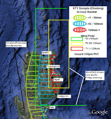
We are also including this rainfall and wind field map. Basically shows our projected 24 hour rainfall until tomorrow afternoon. You can see that eastern Cagayan and Isabela are forecast to receive moderate rain starting today. Amounts of more than 100mm are likely. Meanwhile, areas like Aparri, Tuguegarao, and Baler are forecast to get light to moderate rain with amounts varying from 50-100mm. Other areas west of that such as Ilocos Region are not forecast to get heavy amounts of rain, just some pop up rainshowers throughout tomorrow.

In that map you can also see the yellow rectangle surrounding eastern Cagayan and Isabela. That is where we think tropical storm winds are likely to be felt. TS winds are about 65-120kph. The light green rectangle depicts tropical depression winds which are less thatn 65kph. This is just a simple forecast based on computer models and satellite analysis. We are not saying Areas included here will experience such events throughout the day instead just a way to remind people there on what to expect for Typhoon Songda.

__________________________________
Issued (0730 UTC) 330pm PhT 052611

Wednesday, May 25, 2011

Typhoon Songda (Chedeng) Video Update #5

Songda (Chedeng) is now a Category 4 Typhoon!!! Watch the video for the latest with the track, PAGASA's warnings, and changes in the forecast track.

This is our fifth video update for Typhoon Songda (Bagyong Chedeng). A joint video update from sagitnangbagyo.blogspot.com and westernpacificweather.com. Unfortunately we don't have text version of the update for this morning, our next text update will be this afternoon at 3pm PhT.


__________________________________
Issued (22 UTC) 6am PhT 052611

Typhoon Songda (Chedeng) Update #12

Typhoon Songda (Chedeng) is now rapidly intensifying as it moves slowly across the Philippine Sea. Favorable environment has fueled the RI with maximum sustained winds, based on latest JMA and DVORAK estimates, at around 190kph with gusts reaching as high as 220kph. This makes Songda a Category 3 Major Typhoon on the Saffir-Simpson Scale. TY Songda was last located approximately 720km east southeast of Manila or about 330km east of Catarman, Samar. It is moving west northwestward at about 10kph. Songda has actually moved west for 6 hours but is now beginning to move more WNW-wardly.

Outer rainbands are now beginning to affect much of Bicol Region and Samar Provinces. Light to moderate rain (up to 100mm in 6 hours) should be expected as well as gusty winds of as high as 60kph.

As of 11am today (Philippine Time), PAGASA has raised Public Storm Signal Warning #2 for Catandanuanes, Albay, Sorsogon, Camarines Sur, Camarines Norte, and Samar Provinces. Signal #1 for Northern Leyte, Marinduque, Masbate, Burias and Ticao Islands, S. Quezon, Polilio Islands, and Biliran Islands.
Our forecast remains generally the same. Computer models are now in very good agreement as to the general track. UKMET has shifted east to agree with the rest of the guidance. We are forecasting a WNW movement passing by 200km east of Virac, Catanduanes tonight. Based on the rate of intensification today, we think it could reach Category 4 typhoon by tomorrow morning. There is a small chance it could become a Super Typhoon (Category 5). It should then turn more NW-wardly as the mid-level ridge weakens. It should pass 180km to the east of Aparri, Cagayan by Friday morning. We do not think TY Songda will make a landfall in Northern Luzon as of right now. But tropical storm winds will extend as far as 200km away from the center so provinces of Quezon, Isabela, Aurora, and Cagayan will start to feel the effects as early as tomorrow.

Extended forecast show Songda turning northeastward by Saturday away from Taiwan. It should exit the Philippine Area of Responsibility by Sunday. Next threat would be the Ryuku Islands in Southern Japan including Okinawa).


___________________________________
Issued (0730 UTC) 330pm PhT 052511

Tuesday, May 24, 2011

Typhoon Songda (Chedeng) Update #11

Typhoon Songda (Chedeng) has drifted westward over the past 6 hours. It was last located about 780km east southeast of Manila or about 300km east northeast of Borongan. Maximum sustained winds have increased further to 150kph. As of 5am PAGASA has raised Public Storm Signal Warning #2 for Catandanuanes, Sorsogon, Albay, Camarines Norte, Camarines Sur, and Samar Provinces. Signal #1 for Marinduque, Masbate, Burias and Ticao Islands, Southern Quezon, Polilio Island, and Biliran Island.

Latest ir image continues to show the developing eye and convection flaring in the eyewall. Outer rainbands are moving westward towards the Bicol Region and Samar. Expect light to moderate rain accompanied by gusty winds at times.

Recent developments suggest Songda may be moving more westward than previously thought, this could have major repercussions for Eastern Visayas and Southern Luzon. Next update will be around 3pm to discuss our forecast for Northern Luzon.
__________________________________
Issued (2330 UTC) 730am PhT 052511

Typhoon Songda (Chedeng) Video Update #4

This is our fourth video update for Typhoon Songda (Bagyong Chedeng). A joint video update from sagitnangbagyo.blogspot.com and westernpacificweather.com. Unfortunately we don't have text version of the update for this morning, our next text update will be this afternoon at 3pm PhT.


__________________________________
Issued (20 UTC) 4am PhT 052511

Typhoon Songda (Chedeng) Update #10

Songda (Bagyong Chedeng) has just been upgraded into a typhoon. Typhoon Songda was last located as of 3pm today (Philippine Time) approximately 1020 km east southeast of Manila. Maximum sustained winds have increased to 120kph with gusts as high as 150kph. Songda is moving WNW-ward at 15kph.

Vertical wind shear is relaxing and the dry air NW of TY Songda has begun to wane so we expect Songda to commence rapid intensification today. Microwave imagery as well as recent visual satellite images confirm that an eye is beginning to form. Strong bursts of convection are also seen flaring near the eyewall.

Outer rainbands are also beginning to approach Samar and Bicol provinces so expect deteriorating conditions in the next few hours. As far as rain amounts go, it should be light to moderate or about 30-80mm in the next 6 hours. Winds of up to 20-30kph should also be expected.

Vis sat. image from NRLMRY


As of 11am today, PAGASA has raised Public Storm Signal Warning #1 to Catandanues, Camarines Sur, Albay, Sorsogon, and Samar Provinces.
Our forecast for Typhoon Songda (Chedeng) is in line with most computer models, which have begun to show more agreement. Songda should continue moving WNW and strengthening quickly along the way, becoming a Cat 2 typhoon tomorrow. It could become a Cat 3 typhoon (Major) as early as Wednesday night and should make its closest pass to Luzon by Friday morning.We are thinking of an off-shore track just east of Luzon, less than 100km to the east coast of Cagayan and Isabela. TY Songda should reach a peak intensity of around 200kph during that time. It will then turn to the north and northeast away from Luzon, Batanes, and Taiwan. There is chance Songda becomes a Category 4 typhoon before leaving the PAR but that will depend on the rate of intensification and the overall environment.

By the weekend, TY Songda is forecast to move northeastward towards Okinawa.
__________________________________
Issued (0730 UTC) 330pm PhT 052411

Monday, May 23, 2011

TS Songda (Chedeng) Video Update #3

This is our third video update for Tropical Storm Songda (Bagyong Chedeng). A joint video update from sagitnangbagyo.blogspot.com and westernpacificweather.com. Unfortunately we don't have text version of the update for this morning, our next text update will be this afternoon at 3pm PhT.


__________________________________
Issued (2030 UTC) 430am PhT 052411

TS Songda (Chedeng) Video Update #2

As a supplement to our text update, we are posting our first Video Update for TS Songda. This is a joint weather update with "westernpacificweather.com". A site that gives updates about tropical storms through videos on Youtube. If you don't want to watch the video (about 8min.) you can read our text update below, titled "TS Songda Update #9".

Please leave your comments and suggestions or questions if you have any, they help us in improving our updates in the future!


___________________________________
Issued (0730 UTC) 330pm PhT 052311

TS Songda (Chedeng) Update #9

Tropical Storm Songda (Bagyong Chedeng) continues to move closer to the Philippines. It continues to expand although the rate of intensification has been limited. The storm, though, appears to strengthening steadily again and we expect TS Songda to become a typhoon this afternoon. Convection is building again and that eye feature on the microwave and IR is beginning to develop again.

TS Songda (Chedeng) was last located 1380km ESE of Manila. It has maximum sustained winds of 110kph and gusts of as high as 130kph. It is moving WNW at 20kph (notice the forward speed has increased as well).

As of right now, PAGASA has not raised any Storm Signal Warnings yet.

Recent computer model outputs are in better agreement compared to previous forecasts with the exception of UKMET. Now pay attention because we've noted how this particular model continues to insist on a direct hit on Eastern Luzon (Aurora or Northern Quezon). It is the outlier right now although the possibility of a landfall in NE Luzon (Isabela or Cagayan) remains low to medium. Our forecast here at Sa Gitna ng Bagyo takes TS Songda close to Luzon but not hitting it directly. We also expect it to become a major typhoon (Category 3) with winds of up to 180kph as early as Wednesday night or early Thursday morning. Of course forecasts beyond 2-3 days are always full of uncertainty and we should expect these forecasts to change day by day. Among the various agencies in the Pacific, both the JTWC and the JMA are forecasting a close pass near Luzon. PAGASA, on the other hand, is expecting a direct hit (landfall) in Cagayan or N. Isabela sometime on Friday. Something to keep in mind.

__________________________________
Issued (0730 UTC) 330pm PhT 052311

Sunday, May 22, 2011

TS Songda (Chedeng) Update #8

Tropical Storm Songda has entered the Philippine Area of Responsibility a few hours ago; it now adopts the name "Bagyong Chedeng" assigned by PAGASA. TS Songda remains a strong tropical storm with winds of up to 100kph (and gusts as high as 130kph). Songda is moving WNW at 15kph.

Dry air has limited the development somewhat this past six hours although recent ir imagery depicts convection trying to rebuild on the northwestern side of the storm. It is very likely Songda will attain Typhoon status today. It should continue to strengthen as it moves close to the Philippines, becoming a major typhoon as early as Wednesday. Computer models are actually in good agreement today, forecasting a track just east of Luzon. UKMET is still the outlier which forecasts a landfall somewhere in eastern Luzon, just something to keep in mind.

___________________________________
Issued (2130 UTC) 530am PhT 052311

Tropical Storm Songda Update #7

Tropical Storm Songda ("Pre-Chedeng") continues to strengthen. Maximum sustained winds are now at 100kph. Songda is moving WNW-ward at 12 kph. It is about 2-3 hours away from entering the PAR. Convection continues to build around the center and recent IR imagery suggests that an eye may already be forming. Computer models continue to trend westward and as we've said before, there is a medium chance Songda could hit Luzon.


__________________________________
Issued (1330 UTC) 930pm PhT 052211

TS Songda Video Update #1

As a supplement to our text update, we are posting our first Video Update for TS Songda. This is a joint weather update with "westernpacificweather.com". A site that gives updates about tropical storms through videos on Youtube. If you don't want to watch the video (about 8min.) you can read our text update below, titled "TS Songda Update #6".

Please leave your comments and suggestions or questions if you have any, they help us in improving our updates in the future!


__________________________________
Issued (0730 UTC) 330pm PhT 052211

TS Songda ("Pre-Chedeng") Update #6

Tropical Storm Songda continues to intensify as it nears the Philippine Area of Responsibility. It was last located approximately 1700km southeast of Manila. Maximum sustained winds have increased to 95kph with gusts reaching up to 120kph. Songda is moving WNW-ward at 10kph. It should enter the PAR early tomorrow. Once it does, it will be named "Chedeng" by PAGASA.

The latest satellite pass indicates an improved structure with convection building around the center. An eye is also forming based on this microwave imagery from NRLMRY, indicative of the rapidly developing storm.

Our forecast have shifted slightly to the west to account for the trends from the computer models today. Now based on the data there is a medium chance that TS Songda will hit Luzon. A number of computer models are indicating this including the NOGAPS, UKMET, and the ECMWF. As for the strength, we believe this intensification will continue throughout the next few days. It might even undergo a burst of rapid intensification beginning tomorrow. TS Songda could become a typhoon as early as tomorrow and a major typhoon, with winds of more than 180kph, on Wednesday.


These forecasts can change so keep it right here for updates with regard to the changes in the track.
__________________________________
Issued (0730 UTC) 330pm PhT 052211

Saturday, May 21, 2011

Tropical Storm Songda Update #5

04W has been upgraded to a Tropical Storm. It now has an international name of "Songda". The tropical storm was last located about 100km west northwest of Yap. It has maximum sustained winds of 65kph. Songda is moving WNW at 10kph. The wind shear in the area has begun to relax and so we expect it to continue strengthening as it moves across the Philippine Sea. TS Songda should enter the PAR later tonight; it will be named "Chedeng" by PAGASA.

TS Songda is forecast to become a typhoon late Monday. It could become a major typhoon (Category 3) this Wednesday or Thursday depending on the rate of intensification. Right now, we still don't think it will Luzon and the models are not in good agreement with the track either.
__________________________________
Issued (2130 UTC) 530am PhT 052211

TD 04W Update #4

Tropical Depression 04W continues to battle low to moderate vertical wind shear and thus struggles to organize and gain strength. Maximum winds right now are at 55kph, TD 04W is moving west northwestward at 10kph. Based on the IR image from NRLMRY (below), convection is mainly confined on the southern half, with the northern half being sheared away. Also notice some convection on the northeastern side trying to wrap around the circulation center (in red).

Based on latest data, it seems the wind shear around TD 04W is finally relaxing. If it continues, which is what the forecast is, the environment should be favorable again for TD 04W to become a tropical storm, and then a typhoon. This is what the computer models are generally showing with regards to development.

Our forecast track is on the western half of the model outputs. We think TD 04W is going to continue moving WNW, eventually entering the Philippine Area of Responsibility possibly tomorrow. When that happens, TD 04W will be named "Chedeng" by PAGASA.

TD 04W is forecast to strengthen again in the next 1-2 days becoming a tropical storm on Sunday and then becoming a Typhoon perhaps on Monday night. Our track takes it near the Philippines (Luzon) although right now, we don't expect TD 04W to make landfall in the country. Of course it's still too far away so keep it right here for updates and changes with the forecast.
___________________________________
Issued (730 UTC) 330pm PhT 052111

Friday, May 20, 2011

TD 04W Update #3

04W has been downgraded to a Tropical Depression by the JTWC. Moderate vertical wind shear has inhibited development. Maximum sustained winds are now at 55kph. TD 04W is moving westward at 10kph. More info including our forecast track on our 3pm Update.
__________________________________
Issued (03 UTC) 11am PhT 052111

Tropical Storm 04W Update #2

04W has now been upgraded into a Tropical Storm. The system was last located 310km east of Yap. Maximum sustained winds are at 65kph with gusts reaching up to 85kph. TS 04W is moving west northwest at 10kph. Right now, the convection still looks to be confined on the southern and eastern side of the center but that is expected to improve today. Computer models are forecasting TS 04W to continue strengthening, perhaps becoming a typhoon early next week. It's still too early to say though where it will hit; models suggest the storm will brush extreme Northern Luzon late next week but expect that to change day by day as the computers get better handling on the storm.

__________________________________
Issued (16 UTC) 12am PhT 052111

Tropical Depression 04W Update #1

Edited at 330pm PhT: Invest 98W has just been upgraded by the JTWC into a Tropical Depression. Sustained winds are at 55kph. TD 04W is moving WNW at 5kph.

==========================================================

Invest 98W is now on the verge of becoming a tropical depression. JTWC has already issued a Tropical Cyclone Formation Alert for 98W. It could be upgraded as early as tonight (5pm update by JTWC perhaps). The system is about 650km SSW of Guam or 2400 km east of Manila. Computer models forecast the storm to move west northwestward, slowly strengthening along the way.

__________________________________
Issued (07 UTC) 3pm PhT 052011

Thursday, May 19, 2011

Tropical Update

Invest 98W is beginning to show signs of improved organization. Numerous convection and some banding are now being observed near the center, south of Guam. As mentioned before, computer models are also in good agreement about a possible cyclone formation in two to three days. The exact track and timing are still unknown nor is it certain that storm will directly hit the Philippines.

___________________________________
Issued (0730 UTC) 330pm PhT 051911

Wednesday, May 18, 2011

Tropical Update

Invest 98W still exists in the Pacific despite the lack of serious convection these past two days. The computer models are coming into agreement about a possible disturbance coming out of that area near Chuuk by Friday. GFS, CMC, NOGAPS, and the UKMET, all point to a storm developing and moving westward towards the Philippine Sea. The EURO though continues to delay the timing of a possible storm and instead shows a weak TS forming in Eastern Visayas next week. Of course nothing is certain with these model outputs so we will continue watching the Pacific for possible activity. We'll put the probability to "low" for now.

__________________________________
Issued (07 UTC) 3pm PhT 051811

Monday, May 16, 2011

Tropical Update

Not much going on in the Western Pacific today although there is a new low pressure area that has been spotted southwest of Chuuk in Micronesia.

Invest 98W is still disorganized although latest satellite images show convective activity continuing to flare up. Some computer models are picking up this system and forecasting it to become more organized in the next few days. UKMET and the CMC are the most bullish. ECMWF is also showing a tropical system forming but not until late this week. The said model is forecasting this storm to move westward, perhaps towards the Philippines. However, we have seen the ECMWF do this a few times this year and ended up being wrong so taking this latest computer run with a grain of salt, for now.

___________________________________
Issued (10 UTC) 4pm PhT 051611

Wednesday, May 11, 2011

TD Aere Update #16 [FINAL]

TD Aere continues to move northeastward south of Japan. It has weakened considerably with maximum winds now at 45kph; convection is almost non-existent as well. Aere is forecast to become extratropical today.

This is the final update for Tropical Storm Aere (Bebeng). Rest of the Pacific is quiet expect for a area of invest (95W). We will keep watching the disturbance and post updates if necessary.
__________________________________
Issued (20 UTC) 4am PhT 051211

TS Aere (Bebeng) Update #15

Tropical Storm Aere has exited the Philippine Area of Responsibility early this morning. It is now passing just to the west of Okinawa, about 65km north northeast of Naha. Sustained winds remain at 65kph. Aere is moving northeastward at 35kph.

Latest Radar from JMA: http://www.jma.go.jp/en/radnowc/index.html?areaCode=217

TS Aere is forecast to begin weakening in the next 6-12 hours finally becoming an extra tropical cyclone by Thursday.


Invest 94W in the W. Pacific has dissipated. Next chance of tropical cyclone formation could be late next week.
___________________________________
Issued (07 UTC) 3pm PhT 051111

Tuesday, May 10, 2011

TS Aere (Bebeng) Update #14

TS Aere was last located 350km southwest of Okinawa. It is moving northeast at 25kph. Maximum sustained winds remain at 65kph with gusts of up to 85kph. Aere should exit the Philippine Area of Responsibility this afternoon, passing by Naha a few hours later. Convection is still flaring although mostly displaced east of the circulation center. The storm should weaken by tonight and should complete extratropical transition as early as Thursday.

Next update will be 3pm today.
__________________________________
Issued (2130 UTC) 530am PhT 051111

TS Aere (Bebeng) Update #13

Tropical Storm Aere (Bebeng) has begun to turn to the northeast. It was last located approximately 670km southwest of Okinawa. Aere is moving NE at 25kph. Maximum sustained winds have decreased to 65kph. It should leave the Philippine Area of Responsibility tomorrow (Wednesday).

The circulation center has become exposed and the convective activity has also begun to wane. It should remain as a tropical storm for the next 6-12 hours before weakening into a Tropical Depression once it gets near Okinawa.

Signal #1 is still up for Batanes as of 5pm although we expect that to be dropped by PAGASA by 11pm tonight.

__________________________________
Issued (1330 UTC) 930pm PhT 051011

Monday, May 9, 2011

TS Aere (Bebeng) Update #12

Tropical Storm Aere (Bagyong Bebeng) continues to move away from the country. It was last located about 100km north northeast of Basco, Batanes. Recent strength estimates based on satellite suggest maximum winds have increased slightly to 70kph. Aere is moving northward at around 20kph.

As of 11am, PAGASA still has Storm Signal Warning #1 for Basco, Batanes. All other signal warnings elsewhere have already been dropped.

We are forecasting TS Aere to continue moving to the north, before recurving to the northeast towards Okinawa. The timing depends on the approaching trough and the models generally are in good agreement on this. CMC and the UKMET models though are delaying Aere's turn that's why we are including Kyushu Island (mainland Japan) in our forecast cone. As for wind speeds, TS Aere could strengthen more in the next few hours (maybe to 70-80kph) before gradually weakening as it moves to cooler waters and more hostile environment.

Invest 94W is still poorly disorganized and the computer models are not showing strong development until this weekend or early next week (CMC and ECMWF).

__________________________________
Issued (07 UTC) 3pm PhT 051011

TS Aere (Bebeng) Update #11

Tropical Storm Aere (Bagyong Bebeng) has weakened further as it slowly moves away from Luzon. Aere was last located approximately 170km northeast of Aparri; it has maximum sustained winds of about 70kph. It is moving to the north at about 18kph.

As of 11pm PhT Storm Signal Warning #2 is in effect for Cagayan, Babuyan, and Calayan. Signal #1 for Isabela, Quirino, Ifugao, Mt. Province, Kalinga, Apayao, and Batanes.

TS Aere is forecast to start turning to the northeast today. The recurving will depend on the strength of the Subtropical Ridge situated in the Pacific. Most models are in good agreement on the timing and so we are forecasting TS Aere to leave the Philippine Area of Responsibility as early as Wednesday. It is forecast to pass by Okinawa Wednesday night either as a weak Tropical Storm or a Tropical Depression. Aere should begin extratropical transition on Thursday.

PS: Remember when we said a tropical storm might form this week? The JTWC has issued a "Poor" confidence forecast for the Invest 94W. Computer models are starting to depict the said scenario. Whether it will track towards the Philippines is still too early to say.

__________________________________
Issued (19 UTC) 3am PhT 051011

TS Aere (Bebeng) Update #10

Major changes to our short-term forecast.

It has been very difficult tracking Tropical Storm Aere (Bagyong Bebeng) these past few hours due to its erratic movement as it traverses Isabela and Cagayan provinces. Recent satellite and microwave images, though, have helped us locate the center of the storm and its current movement as well. We have fair confidence about TS Aere's latest position which is approximately 60km east of Tuguegarao. Remember that we have earlier forecast Aere to pass 20km east of Tuguegarao. Clearly this hasn't happened, nor will we see it track close to Aparri, unless a major turn happens soon.

Current trends show TS Aere moving generally northward. It should reach Sta. Ana, Cagayan (about 60km east of Aparri) by 9pm tonight. Storm strength appears unchanged so expect winds to remain at around 70-80kph for the next few hours.

Storm Signal Warning #2 for Cagayan and Isabela. Signal #1 for Aurora, Quirino, Ifugao, Mt. Province, Kalinga, Apayao, Babuyan, Calayan Group of Islands, and Batanes. From PAGASA as of 5pm PhT

Again, this is a change on our short-term forecast. We will correct our medium-term forecast (if needed) later on our 3am storm update.

___________________________________
Issued (09 UTC) 5pm PhT 050911

TS Aere (Bebeng) Update #9

Tropical Storm Aere (Bagyong Bebeng) is now moving across northeastern Luzon. It was last located approximately 100km north of Casiguran, Aurora or about 80km southeast of Tuguegarao, Cagayan. It has weakened since it made landfall; maximum sustained winds are now at 80kph. TS Aere is moving north-northwestward at 15kph.

Much of our short-term forecast from our previous update (#8) haven't changed. By 4 or 5pm, TS Aere should be within 20-30km of Tuguegarao. By 8pm tonight, TS Aere should be within 20km of Aparri, Cagayan. We also expect winds to continually decrease, but still remain within Tropical Storm strength. TS Aere will then pass by Basco, Batanes on Tuesday morning. The storm should exit the Philippine Area of Responsibility as early as Wednesday morning, passing near Okinawa, Japan by Wednesday night. It might also regain some strength on its way to Okinawa, as depicted by the models. Aere should then weaken rapidly by Thursday as it encounters hostile environment up north.

___________________________________
Issued (07 UTC) 3pm PhT 050911

Sunday, May 8, 2011

TS Aere (Bebeng) Update #8

Landfall update and Short-Term Forecast

Tropical Storm Aere (Bagyong Bebeng) has made landfall in Southeastern Isabela about an hour ago. It is now 90km north northeast of Casiguran, Aurora. Winds have weakened to 85kph due to land interaction. TS Aere is moving north northwestward at around 18kph. Storm Signal Warning #2 is up for Aurora, Isabela, Quirino, Nueva Viscaya, Ifugao, Mt. Province, Kalinga, and Cagayan. Signal #1 for Northern Quezon, Polilio Island, Nueva Ecija, Benguet, Ilocos Sur, Abra, Ilocos Norte, Apayao, Babuyan, Calayan Group of Islands, and Batanes.

TS Aere is forecast to continue moving NNW-ward passing within 20km east of Tuguegarao at around 4pm. It should then pass by Aparri, Cagayan at around 8 or 9pm tonight. TS Aere should also continue to lose some strength because of the mountainous terrain in Northern Luzon. However, we are now expecting it to remain as a tropical storm throughout its crossing over the island.

A more in-depth update will be posted at 3pm today for the medium range forecast for TS Aere.

PAGASA's Storm Signal Warnings as of 11am PhT

Short-term Forecast Track

__________________________________
Issued (4 UTC) 12pm PhT 050911

TS Aere (Bebeng) Update #7

Another quick update regarding TS Aere. It was last located approximately 90km northeast of Casiguran, Aurora. It has slightly weakened, mainly due to the close proximity to land. It is moving north-northwestward at 15kph. TS Aere is approaching Divilacan and Palanan and should brush Eastern Isabela in an hour or so. TS Aere should continue moving NNW-ward passing east of Tuguegarao this afternoon.

This is a satellite image taken at 9am PhT (from NRLMRY):

___________________________________
Issued (0130 UTC) 930am PhT 050911

TS Aere (Bebeng) Update #6

Just a brief update on TS Aere (Bebeng) with some changes on our short-term forecast. The storm is close to making landfall in Southern Isabela. It was last located approximately 70km eastnortheast of Casiguran, Aurora and moving north-northwestward at 15kph. Landfall likely 80km to the northeast of Casiguran at around 9 or 10am.

As of 5am, Storm Signal Warning #2 is in effect for Aurora, Isabela, Quirino, Nueva Viscaya, Ifugao, Mt. Province, Kalinga, and Cagayan. Signal #1 for Camarines Norte, Northern Quezon, Polilio Island, Nueva Ecija, Benguet, Ilocos Sur, Abra, Ilocos Norte, Apayao, Babuyan, Calayan Group of Islands, and Batanes. Storm signals has been dropped elsewhere (including Metro Manila).

The rest of our forecast (read Update #5) has not changed.
__________________________________
Issued (23 UTC) 7am PhT 050911

TS Aere (Bebeng) Update #5

Tropical Storm Aere (Bebeng) has regained its strength after being weakened by the land interaction early Sunday morning. Maximum winds are back to 95kph. Aere was last located around 310km east northest of Manila or about 70km east southeast of Casiguran, Aurora. The storm is moving to the northwest at about 15kph.

Signal # 2 is raised for Camarines Norte, Northern Quezon, Polilio Island, Aurora, Nueva Ecija, Quirino, Nueva Vizcaya, Ifugao, and Isabela. Signal #1 for Camarines Sur, Rest of Quezon, Marinduque, Batangas, Cavite, Laguna, Rizal, Bulacan, Bataan, Pampanga, Tarlac, Zambales, Pangasinan, La Union, Benguet, Mt. Province, Ilocos, Sur, Kalinga, Cagayan, and Metro Manila.

TS Aere (Bebeng) is forecast to make landfall in 2-3 hours. Based on current trends, Aere is likely to make landfall in Southern Isabela; 60km northeast of Casiguran. It will then weaken to a tropical depression as it crosses the rugged terrain of Luzon. It will pass by Tuguegarao and Aparri before exiting the island late Monday night. Aere should then make a turn to the northeast, possibly heading towards Okinawa. Models are in good agreement about the short to medium range forecast; NOGAPS is the western outlier on the storm track.
__________________________________
Issued (20 UTC) 4am PhT 050911

Saturday, May 7, 2011

TS Aere (Bebeng) Update #4

Tropical Storm Aere (Bebeng) has made landfall in Catanduanes earlier this morning. This disrupted the storm's strengthening although recent satellite images show deep convection near the center has begun to improve again. Aere was last located approximately 100km north northwest of Virac, Catanduanes. The storm is now moving WNW at around 15kph. Maximum sustained winds remain at 95kph with gusts reaching up to 120kph. Aside from the winds, Tropical Storm Bebeng is also bringing heavy rains along parts of the Bicol Region and to Samar Provinces. According to WMO, Catarman, Northern Samar, has recorded more than 300mm of rain in the past 24 hours; Masbate reported 180mm while Catbalogan reported 150mm.

10 provinces are still under Public Storm Signal Warning #2 by PAGASA: Catanduanes, Camarines Norte, Camarines Sur, Northern Quezon, Polilio Island, Aurora, Nueva Ecija, Quirino, and Isabela. Signal #1 remains in effect for Sorsogon, Albay, Northern Samar, Southern Quezon, Laguna, Rizal, Bulacan, Pampanga, Tarlac, Pangasinan, La Union, Mt. Province, Kalinga, Ifugao, and Southern Cagayan.

The forecast for TS Aere remains generally the same. TS Aere should continue tracking west northwestward, gaining some more strength (possibly just below the typhoon-threshold). Our forecast landfall is somewhere north of Casiguran, Aurora early Monday morning. Aere will then weaken, becoming a Tropical Depression before re-emerging off Luzon Strait by Monday evening/early Tuesday. The models are still in disagreement as to when the storm will recurve to Okinawa. GFS is the earliest with the turn while the NOGAPS is the latest. We are going with a blend of these models and we are generally expecting that Aere will avoid hitting Taiwan directly.
Forecast Track


PSWS as of 11am

__________________________________
Issued (07 UTC) 3pm PhT 050811

Tropical Storm Aere (Bebeng) Update #3

Tropical Storm Aere (Bebeng), last located 500km east southeast of Manila, has strengthened considerably these past 12 hours. Maximum sustained winds are now at 85 kph with occasional gusts reaching up to 100kph. The storm structure continues to get better with improved banding and convection, especially near the circulation center.

There are some changes regarding our forecast for TS Aere. Based on latest satellite images, it looks like the storm is moving more towards the west than what was forecast. Therefore, we have shifted our forecast track to the south, with the storm possibly making landfall in Catanduanes in the next few hours. Aere will continue moving WNW making its second landfall near Casiguran, Aurora by Monday morning. Computer models are generally in good agreement as to the track with the GFS being the southern outlier and the CMC being the northern outlier. Right now, our forecast agrees with that of the NOGAPS' and the UKMET's which are a compromise of the two solutions by the GFS and CMC (haven't seen the ECMWF yet as of posting time). Furthermore, based on current trends, TS Aere is forecast to gain a peak intensity just below the typhoon-threshold which is around 110kph. It will quickly weaken though as it crosses Northern Luzon.

PAGASA, meanwhile, has raised Storm Signal Warning # 2 to Sorsogon, Ticao Island, Albay, Camarines Norte, Camarines Sur, Southern Quezon, Catanduanes, and Northern Samar. The following areas are under Signal #1: Biliran, Masbate, Romblon, Marinduque, Northern Quezon, Polilio Island, Nueva Vizcaya, Nueva Ecija, Aurora, Quirino, Isabela, Eastern Samar, and Western Samar.

Forecast TrackPublic Storm Warning Signal as of 11pm

__________________________________
Issued (1830 UTC) 230am PhT 050811

Friday, May 6, 2011

TS 03W (Bebeng) Update #2

Tropical Storm 03W (Bebeng) continues to organize as it moves towards Luzon. Although it didn't gain strength these past 12 hours, satellite images show improved banding near the center; convective activity is still mainly confined in the western half of the system, however. Because of this, moderate to heavy rain continue to drench parts of Visayas and the Bicol Region. Catbalogan, Samar, for example, has received 150mm of rain these past 24 hours. Rainfall amounts in the region are expected to rise further so floods and landslides are highly likely.

PAGASA has raised Public Storm Signal Warning #1 to the following areas: Camarines Sur, Camarines Norte, Albay, Catanduanes, Sorsogon, Masbate, Ticao, Burias Is., Polilio Is., Leyte, Samar, and Biliran. These areas should expect gusty winds and rainfall amounts of as much as 200mm in a 12 hour period.

TS 03W (Bebeng) is forecast to continue its present movement, strengthening along the way. It will reach a peak intensity of around 100kph before making landfall somewhere near the Aurora-Isabela border on Monday morning. It will then weaken to a tropical depression as it moves across Northern Luzon. It will exit the island by Tuesday as a weak TD.

Satellite Analysis


Forecast Track

__________________________________
Issued (0630 UTC) 230pm PhT 050711