Like our FACEBOOK PAGE for the latest updates on this storm!
Maysak (Bagyong Chedeng) has weakened to a Tropical Depression and is now dissipating over the South China Sea (West Philippine Sea). The center of Maysak was last located approximately 330km northwest of Laoag City, Philippines or about 480km southeast of Hong Kong. Maximum winds are at 35 to 60kph. Maysak is currently moving northwestward at 20kph.
PAGASA has lowered all their Public Storm Warning Signals
IR Image from NRLMRY
Latest satellite image shows Maysak looking very disorganized now with the inner-core almost non-existent. However, occasional light to moderate rains are still possible especially across Southern Taiwan and parts of Southern China.
This is our final update on Maysak (Chedeng). A Tropical Cyclone has formed near the Caroline Islands (Tropical Storm Haishen) but is expected to remain over water and eventually dissipate due to strong wind shear in the region.
Like our FACEBOOK PAGE for the latest updates on this storm!
Tropical Storm Maysak (Bagyong Chedeng) continues to weaken as it nears making landfall in Northern Luzon. The storm center was last located approximately 80km northeast of Casiguran, Aurora or about 280km northeast of Manila. Maximum sustained winds are down to 85kph with gusts of up to 110kph. TS Maysak is currently moving northwestward at 15kph.
Due to the weakened nature of the Chedeng, PAGASA has lowered Public Storm Warning Signals #2 and #3. However, Signal #1 is still in effect for Isabela, Aurora, Quirino, and Polilio Island. Residents in the said areas are still advised to prepare for strong winds as well as widespread heavy rains.
IR Image from NRLMRY
Latest satellite image shows strong convective activity associated with Tropical Storm Maysak nearing the island of Luzon. The core of Maysak continues to deteriorate and we expect the system to dissipate as it crosses Luzon today. However, Maysak will still bring dangerous weather conditions today especially across Northern Luzon.
Radar Image from PAGASA (DOST)
Latest radar image from Baler, Aurora shows bands of light to moderate rains moving towards Luzon. Expect wet weather conditions to spread into much of Central and Northern Luzon. Even parts of Metro Manila may see some rain showers today. However, the bulk of heavy rains will likely fall across the Cordillera Region where as much as 200mm of accumulation is possible. Landslides and flash floods are possible so residents are advised to remain cautious against these threats.
For the latest Weather Warnings and Forecasts from PAGASA, please click HERE
Tropical Storm Maysak (Bagyong Chedeng) is forecast to make landfall in the Aurora-Isabela border within the next 3-6 hours. The system will rapidly lose strength and even dissipate as it crosses Luzon today. However, rains will likely linger across the region through tomorrow.
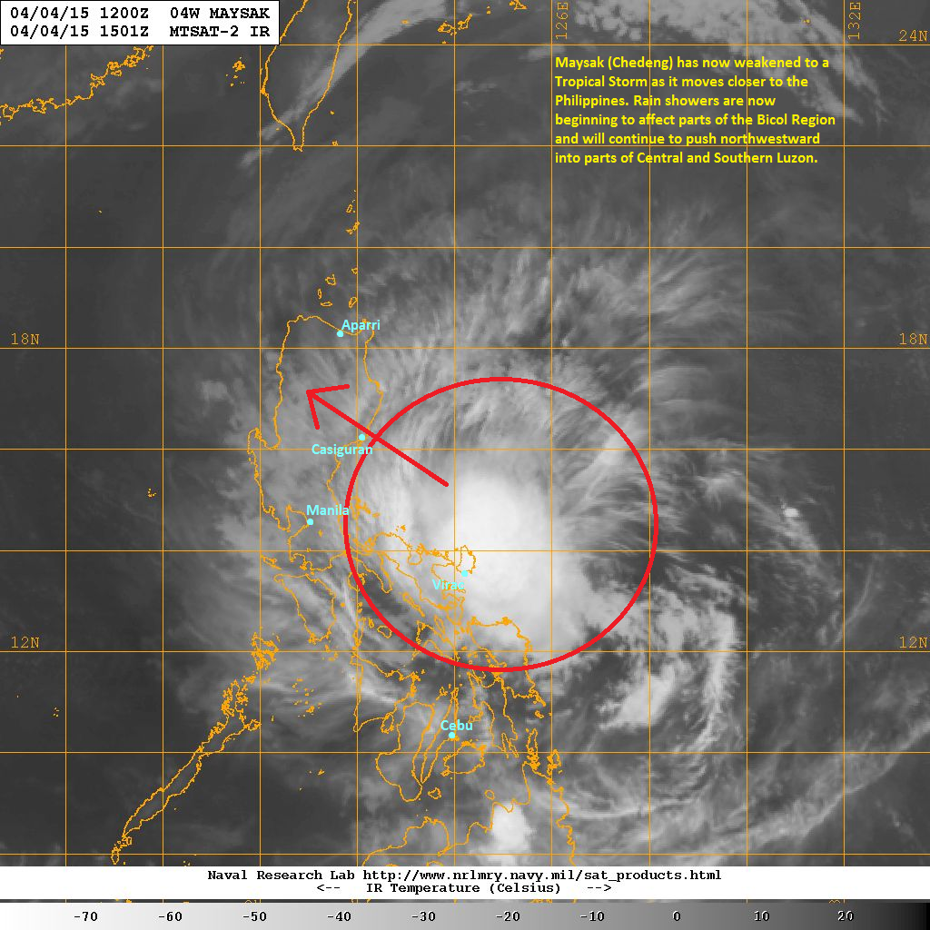
Maysak (Bagyong Chedeng) has now weakened to a Tropical Storm as it moves closer to the Philippines. The storm center was last located approximately 140km north of Virac, Catanduanes or about 340km east of Manila. Maximum sustained winds are down to 110kph with gusts of up to 140kph. TS Maysak is currently moving westward at 20kph.
As of 11pm this evening, PAGASA has raised Public Storm Warning Signal #3 for Isabela and Aurora. Signal #2 for Northern Quezon, Polilio Island, Nueva Ecija, Southern Cagayan, Kalinga, Mt. Province, Ifugao, Benguet, Nueva Vizcaya, Quirino, and Catanduanes. Signal #1 for Rest of Cagayan, Babuyan Island, Apayao, Ilocos Norte, Ilocos Sur, Abra, La Union, Pangasinan, Tarlac, Pampanga, Bulacan, Rizal, Rest of Quezon, Camarines Norte, and Camarines Sur.
IR Image from NRMRY
Latest satellite image shows Maysak becoming more elongated as it continues to suffer from strong shear in the region. Tropical Storm Maysak is also close enough that some of its rainbands are starting to affect parts of the Bicol Region particularly in Catanduanes and Camarines Provinces. We expect those light to moderate rains to continue through the morning hours.
Tropical Storm Maysak will continue moving northwestward and eventually make landfall near Casiguran, Aurora tomorrow morning. Widespread rains are expected across Central and Northern Luzon which can cause landslides and flash floods. Parts of Metro Manila may see some rain showers tomorrow as well. Maysak will exit Luzon tomorrow evening.
WE ARE NOT AN OFFICIAL WEATHER AGENCY! For the latest Official Weather Bulletins from PAGASA, please click HERE
Like our FACEBOOK PAGE for the latest updates on this storm!
Maysak (Bagyong Chedeng) continues to weaken and is now down to a Category 1 Typhoon. The center of Maysak was last located approximately 240km northeast of Virac, Catanduanes or about 550km east of Manila. Maximum sustained winds are down to 140kph with gusts of up to 175kph. Typhoon Maysak is moving westward at 25kph.
As of 11am this morning, PAGASA has issued Public Storm Warning Signal #2 for Isabela, Southern Cagayan, Kalinga, Mt. Province, Ifugao, Benguet, Nueva Vizcaya, Quirino, Aurora, and Catanduanes. Signal #1 is in effect for the rest of Cagayan, Babuyan Island, Apayao, Ilocos Norte, Ilocos Sur, Abra, La Union, Pangasinan, Nueva Ecija, Tarlac, Pampanga, Bulacan, Rizal, Quezon, Camarines Norte, and Camarines Sur. The provinces listed above are expected to feel the effects from Chedeng within the next 24 hours. Residents living in these areas should coordinate with their local officials for the latest warnings and evacuation orders if there are any.
IR Image from NRLRMY
Latest satellite image continues to show a much weaker Maysak compared to yesterday. However, please do not underestimate this Typhoon as it can still bring dangerous conditions once it makes landfall in Northern Luzon tomorrow. Heavy rains and strong winds are still expected, especially along the coastal areas of Aurora and Isabela Provinces.
Typhoon Maysak (Bagyong Chedeng) is moving closer to the Philippines and its outer rain bands will start bringing light to moderate rains across the Bicol Region, particularly in Catanduanes. These rains showers will spread northwestward and will eventually impact parts of Central and Northern Luzon.
Maysak is forecast to make landfall near the Aurora-Isabela border, just north of Casiguran by 8am tomorrow morning (Sunday). It will cross Northern Luzon bringing heavy rains across the region. It will also continue weakening, becoming a minimal tropical storm as it exits into the South China Sea (West Philippine Sea) by tomorrow evening.
We'll have another update later tonight. Stay safe!
WE ARE NOT AN OFFICIAL WEATHER AGENCY! For the latest Official Weather Bulletins from PAGASA, please click HERE
Like our FACEBOOK PAGE for the latest updates on this storm!
Typhoon Maysak (Bagyong Chedeng) continues to weaken as it moves slowly towards the Philippines. The system was last located approximately 550km east northeast of Virac, Catanduanes or about 880km east of Manila. Maximum sustained winds are 155kph with gusts of up to 195kph. Typhoon Maysak is moving westward at 20kph.
As of 5pm this afternoon, PAGASA has issued Public Storm Warning Signal #1 for Isabela, Aurora, Quirino, Quezon, Polilio Island, Catanduanes, Camarines Norte, and Camarines Sur. Residents are advised to continue monitoring the developments of this typhoon and always heed the warnings of local officials!
IR Image from NRLMRY
We're seeing a much different Maysak today on satellite. Strong wind shear and the presence of dry air have both led to the continued weakening of Maysak. Fortunately, this typhoon should continue weakening before it moves towards the Philippines.
Typhoon Maysak (Bagyong Chedeng) is forecast to make landfall near the Aurora-Isabela Provinces border by early Sunday morning. Due to the unfavorable conditions in the region, we expect Maysak to weaken to a Tropical Storm before making landfall in Luzon. Despite the weakness, we still expect widespread rains to fall in Northern Luzon which can cause flooding and landslides especially in mountainous areas.
Maysak will, then, exit into the South China Sea (West Philippine Sea) by Sunday afternoon.
WE ARE NOT AN OFFICIAL WEATHER AGENCY! For the latest Official Weather Bulletins from PAGASA, please click HERE
Like our FACEBOOK PAGE for the latest updates on this storm!
Typhoon Maysak (Bagyong Chedeng) continues to weaken as it moves across the Philippine Sea today. The eye of Maysak was last located approximately 940km east of Catarman, Northern Samar or about 1,350km east southeast of Manila. Maximum sustained winds are at 215kph with gusts of up to 260kph. Typhoon Maysak is currently moving west northwestward at 15kph.
For more information and forecasts, please watch our in-depth Video Update below:
We'll have our next update later this evening. Stay safe!
WE ARE NOT AN OFFICIAL WEATHER AGENCY! For the latest Official Weather Bulletins from PAGASA, please click HERE
Like our FACEBOOK PAGE for the latest updates on this storm!
For a more in-depth discussion on the current conditions and forecast for Maysak, please watch our Video Update below:
Super Typhoon Maysak (Bagyong Chedeng) has maintained its Category 5 intensity as it moves away from Yap State. The eye of Maysak was last located approximately 200km northwest of Yap or about 1,280km east of Borongan, Eastern Samar. Maximum sustained wins remain at 260kph with gusts of up to 315kph. STY Maysak is currently moving west northwestward at 20kph.
IR Image from NRLMRY
Latest satellite image shows the eye of Maysak remains perfectly circular and symmetrical. Maysak underwent an eyewall replacement cycle overnight as it moved near the island of Yap. Cloud tops have warmed slightly this morning due to the EWRC. However, we expect a brief period of re-intensification overnight before finally weakening beginning Friday.
Forecast Track (NOT OFFICIAL!)
Our forecast track for Maysak remains generally the same as computer models have converged on a possible Luzon landfall this weekend. Maysak is forecast to enter the Philippine Area of Responsibility by tomorrow morning (Thursday) by which time it will be given a local name of 'Bagyong Chedeng' by PAGASA.
Due to strong vertical wind shear and cooler sea surface temperatures, Maysak is forecast to weaken significantly before moving into the Philippines. Latest forecast consensus is showing a possible landfall somewhere in the Aurora or Isabela Provinces by early Sunday morning. Depending on the rate of weakening, Maysak may retain its strong typhoon-intensity as it makes landfall.
We urge everyone in the island of Luzon to continue monitoring the progress of Maysak. Please make sure to always coordinate with your local officials and PAGASA for the latest OFFICIAL warnings and weather bulletins.
We'll have another update later tonight. Stay safe!
Like our FACEBOOK PAGE for the latest updates on this storm!
Maysak has rapidly intensified overnight and is now a Category 4 Typhoon. The system was last located approximately 380km east northeast of Yap or about 520km southwest of Guam. Maximum sustained winds are now at 230kph with gusts of up to 280kph. Typhoon Maysak is currently moving westward at 25kph.
The National Weather Service in Guam has now issued a Typhoon Warning for the State of Yap. Winds of up to 75mph (120kph) are expected across Yap while winds of up to 250kph (155mph) are forecast across the small atolls of Ulithi and Fais beginning tonight. Storm surges of up to 25feet are also possible. Residents are strongly advised to coordinate with local officials and seek shelters away from the shore.
For the latest warnings from the National Weather Service, please click HERE
IR Image from NRLMRY
Latest satellite image shows Maysak with its symmetrical and cloud-free eye surrounded by strong and deep convective activity. Radial outflow remains excellent as well and feeder bands continue to enhance Maysak's intensity. Short-term forecasts suggest that Maysak may reach a peak intensity of Category 5 Super Typhoon later this evening, just as it moves near the island of Yap.
Please watch our Video Update below for more information on the system's impacts and where it will head next:
We'll have another update later tonight. Stay safe!
Like our FACEBOOK PAGE for the latest updates on this storm!
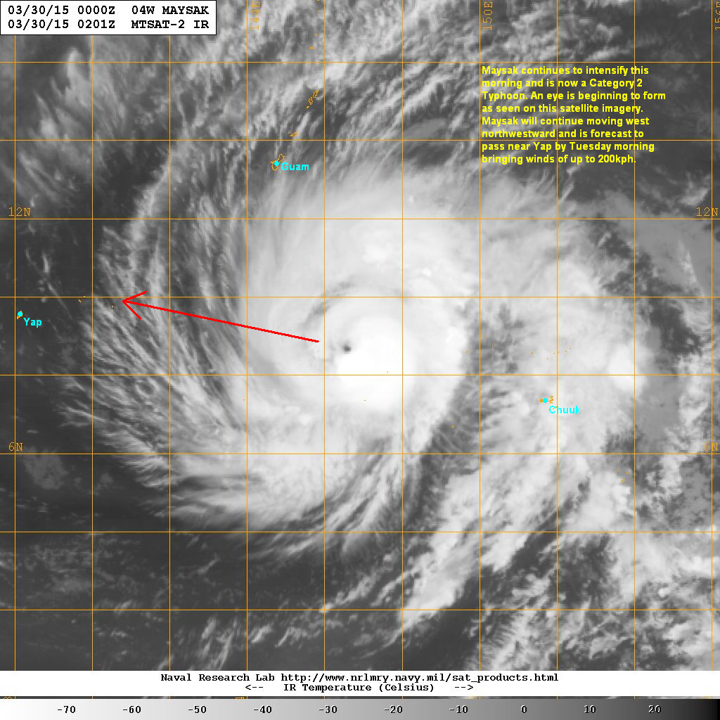
Maysak continues to intensify this morning and is now a Category 2 Typhoon. The system was last located approximately 540km south southeast of Guam or about 920km east southeast of Yap. Maximum sustained winds are now at 155kph with gusts of up to 195kph. Typhoon Maysak is currently moving west northwestward at 25kph.
The National Weather Service in Guam has issued a Typhoon Warning for Fais, Ulithi, and Faraulep in the State of Yap. Winds of more than 74mph (120kph) are expected to occur in as little as 12 hours. Residents are advised to move to sturdy shelters away from the shoreline. Please coordinate with your local officials for warnings and emergency preparedness instructions.
Click HERE for the latest Weather Warnings from the NWS
IR Image from NRLMRY
Latest satellite image shows an eye is beginning to form surrounded by increasing convective activity. Maysak remains in a generally favorable environment with light to moderate wind shear, warm sea surface temperatures, and good radial outflow. We expect the system continue intensifying, attaining Category 3 status by tonight. It could even undergo a period of rapid intensification before moving near Yap.
Forecast Track (NOT OFFICIAL!)
Our latest forecast track remains generally the same. We think Maysak will continue moving on a west-northwesterly trajectory over the next 3 to 4 days. It is forecast to move near the island of Yap by Tuesday morning as a strong and dangerous Category 4 Typhoon. Winds of up to 200kph are possible in the island.
By Thursday, Maysak is expected to enter the Philippine Area of Responsibility and will be given the local name 'Bagyong Chedeng' by PAGASA. Based on the conditions in the region, Maysak should slowly weaken as it moves into the Philippine Sea. Current track projections still diverge but the chances of a Philippine impact is becoming more likely. Whether or not Maysak remains a strong typhoon by then is still unknown at this time.
Like our FACEBOOK PAGE for the latest updates on this storm!
IR Image from NOAA
Typhoon Maysak continues to intensify this morning as it heads towards the state of Yap. The system was last located approximately 380km west of Chuuk State or about 700km southeast of Guam. Maximum sustained winds are now at 150kph with gusts of up to 185kph. Typhoon Maysak is currently moving westward at 25kph.
Watch our latest Video Update below for more information and where Maysak will head next:
We'll have another update later this morning. Stay safe!
Like our FACEBOOK PAGE for the latest updates on this storm!
Maysak has rapidly intensified since our last update and is now a Category 1 Typhoon. The system was last located approximately 160km west northwest of Chuuk or about 860km southeast of Guam. Maximum sustained winds are now at 140kph with gusts of up to 175kph. Typhoon Maysak is currently moving westward at 20kph.
Due to the impending threat from Maysak, the National Weather Service in Guam has issued numerous Typhoon Watches and Tropical Storm Warnings across Micronesia particularly in the state of Yap. For the latest information regarding these weather warnings, please click HERE (NWS)
IR Image from NRLMRY
Latest satellite image shows the central dense overcast (CDO) associated with Maysak is becoming much better organized. Convective activity remains strong and an eye is starting to appear on the satellite. Radial outflow is also very good and is helping induce that rapid intensification that we've observed in the past 24 hours.
Typhoon Maysak should continue to intensify in the next few days as atmospheric conditions in the region remain favorable for Tropical Cyclones. Computer models are starting to converge on a track that will take Maysak near Yap by Tuesday afternoon (March 31) possibly as a strong Category 3 or even Category 4 Typhoon. Long-range forecasts depict a possible westward track which could take Maysak towards the Philippines by Thursday or Friday. Readers from the Philippines should continue monitoring the progress of this typhoon as it could impact the country later in the week.
Like our FACEBOOK PAGE for the latest updates on this storm!
Tropical Depression 04W has intensified this morning and has been upgraded into Tropical Storm Maysak. The system was last located approximately 300km east of Chuuk or about 1,270km southeast of Guam. Maximum sustained winds are now at 75kph with gusts of up to 95kph. TS Maysak is currently moving westward at 15kph.
The National Weather Service in Guam has issued a Tropical Storm Warning for Fananu and Chuuk for the possibility of winds of up to 80kph (50mph). For the latest warnings from NWS, please click HERE
IR Image from NRLMRY
Latest satellite image shows Maysak becoming more organized this morning with a developing central dense overcast and good formative banding. Convection has also increased and become more consolidated, especially near the low-level circulation center. Maysak is in an area of favorable conditions and is expected to steadily intensify in the next few days.
Forecast Track (NOT OFFICIAL!)
Our preliminary forecast shows Tropical Storm Maysak moving west northwestward, moving near the state of Chuuk tonight and into tomorrow morning. It will be passing well south of Guam by Monday and could even become a Typhoon around that time frame. By Tuesday, Maysak is forecast to be a Category 2 Typhoon as it nears the state of Yap.
We expect Maysak to enter the Philippine Area of Responsibility by Wednesday as a strong Category 3 Typhoon, by which time PAGASA will assign the local name of "Bagyong Chedeng". Our preliminary forecast is based on the consensus from the numerous computer model guidance that we use. This is not set in stone just yet and it is still too early to determine the impacts this storm will bring to the Philippines.
We'll continue to keep you abreast on the developments of Tropical Storm Maysak.
Like our FACEBOOK PAGE for the latest updates on this storm!
A new Tropical Cyclone has formed in the Western Pacific this morning. Tropical Depression 04W was last located approximately 60km west southwest of Pohnpei in the Caroline Islands. Maximum sustained winds are at 45kph with gusts of up to 65kph. TD 04W is currently moving westward at 15kph.
IR Image from NRLMRY
Latest satellite image shows Tropical Depression 04W in its early stages of development. Convective activity has been increasing, especially near the center of circulation. The island of Pohnpei is currently reporting winds of up to 30kph along with light rain showers. We expect the conditions in the island to improve as TD 04W moves away in the next 12 hours.
Tropical Depression 04W will continue moving generally westward over the next few days. The system is expected to steadily intensify as the environmental conditions in the region should be conducive for further development. The system might even become a Typhoon in the next 3 days. However, it is still too early to tell whether TD 04W will eventually impact the Philippines.
We'll continue monitoring the progress of this Tropical Depression and will update by tomorrow.