Issued (01 UTC) 9am PhT 050114
____________________________
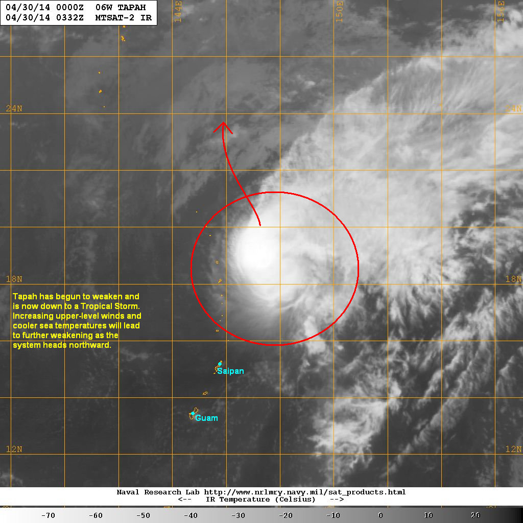
Tropical Storm Tapah is now weakening rapidly as it moves across the Pacific. The storm center was last located approximately 620km north of Saipan. Maximum sustained winds have weakened to 65kph with gusts of up to 85kph. TS Tapah is moving northwestward at 20kph.
IR Image from NRLMRY
Latest satellite image shows that convection associated with Tropical Storm Tapah is almost gone. Furthermore, the increasing upper-level winds have left the low-level circulation center fully exposed. Aside from the strong winds, sea surface temperatures are also becoming too cold to support cyclone intensity.
Tropical Storm Tapah will continue weakening and should dissipate within the next 24 hours. It will continue moving northward across the Pacific and shouldn't be a threat to land anymore.
This will be our final update on Tapah.
Showing posts with label 06W (Tapah). Show all posts
Wednesday, April 30, 2014
Tuesday, April 29, 2014
Tropical Storm Tapah Update #4
Issued (0430 UTC) 1230pm PhT 043014
_________________________________
Tropical Storm Tapah has begun to weaken as it moves across the Pacific.The storm was last located approximately 470km north northeast or 690km north northeast of Guam. Maximum sustained winds are down to 95kph with gusts of up to 120kph. TS Tapah is moving north northwestward at 15kph.
IR Image from NRLMRY
Latest satellite image shows that the central convection is becoming elongated and is eroding, especially on the southern half of the circulation. Increasing upper-level winds are beginning to take a toll on the system with the core becoming weaker over the past 12 hours.
Tapah will continue weakening as it moves further north. It will still impact the islands in the Marianas, although most of them are uninhabited. Tapah should, then, dissipate within the next 48 hours as it moves into increasingly-unfavorable region in the Pacific.
We'll have another update later tonight.
Labels:
06W (Tapah),
2014 Typhoon Season
Typhoon Tapah Update #3
Issued (1230 UTC) 830pm PhT 042914
________________________________
Tapah intensified into a Category 1 Typhoon earlier today. It was last located approximately 300km north northeast of Saipan or about 520km northeast of Guam. Maximum sustained winds are at 120kph with gusts of up to 150kph. Typhoon Tapah is moving northward at 10kph.
IR Image from NRLMRY
Latest satellite image shows the convection in and around the center remains strong. However, the eye that was partially visible on satellite is no longer apparent. Nevertheless, banding in the core is still well-established and will keep the system in this intensity for at least the next few hours.
Typhoon Tapah will move well north of Saipan but will still impact parts of the Mariana Islands. It should also begin to weaken as it moves farther north into the Pacific. Cooler sea temperatures and increasing upper-level winds will cause the system to lose strength rapidly over the next two to three days.
We'll have our next update tomorrow morning.
Labels:
06W (Tapah),
2014 Typhoon Season
Monday, April 28, 2014
Tropical Storm Tapah Update #2
Issued (00 UTC) 8am PhT 042914
____________________________
Tropical Depression 06W has intensified rapidly overnight and has been upgraded to Tropical Storm Tapah. The storm's center was last located approximately 360km northeast of Guam. Maximum sustained winds have increased to 100kph with gusts of up to 130kph. TS Tapah is moving northward at 15kph.
As of 8am this morning, Tropical Storm Warnings are in effect for Alamagan, Pagan, Saipan, and Tinian. A Typhoon Watch is in effect for Alamagan and Pagan. Please monitor the developments of this cyclone and always follow the forecasts and warnings of your local officials.
IR Image from NRLMRY
Latest satellite image shows the central convection continuing to strengthen and expand. Tropical Storm Tapah remains in a region favorable for further development. Sea surface temperatures are warm enough and upper-level winds support excellent poleward outflow. Dry air is also kept at a minimum.
Tropical Storm Tapah will continue moving northward before turning northwestward and will pass well north of Guam and Saipan. Windy conditions and occasional rains are still possible, however. The northern portions of the Mariana Islands will experience stormy conditions over the next 24 to 48 hours.
We'll have another update later today.hg
Labels:
06W (Tapah),
2014 Typhoon Season
Subscribe to:
Comments (Atom)


