WE ARE NOT AN OFFICIAL WEATHER AGENCY! For the latest Official Weather Bulletins from PAGASA, please click HERE
Like our FACEBOOK PAGE for the latest updates on this storm!
Typhoon Maysak (Bagyong Chedeng) continues to weaken as it moves across the Philippine Sea today. The eye of Maysak was last located approximately 940km east of Catarman, Northern Samar or about 1,350km east southeast of Manila. Maximum sustained winds are at 215kph with gusts of up to 260kph. Typhoon Maysak is currently moving west northwestward at 15kph.
For more information and forecasts, please watch our in-depth Video Update below:
We'll have our next update later this evening. Stay safe!
WE ARE NOT AN OFFICIAL WEATHER AGENCY! For the latest Official Weather Bulletins from PAGASA, please click HERE
Like our FACEBOOK PAGE for the latest updates on this storm!
For a more in-depth discussion on the current conditions and forecast for Maysak, please watch our Video Update below:
Super Typhoon Maysak (Bagyong Chedeng) has maintained its Category 5 intensity as it moves away from Yap State. The eye of Maysak was last located approximately 200km northwest of Yap or about 1,280km east of Borongan, Eastern Samar. Maximum sustained wins remain at 260kph with gusts of up to 315kph. STY Maysak is currently moving west northwestward at 20kph.
IR Image from NRLMRY
Latest satellite image shows the eye of Maysak remains perfectly circular and symmetrical. Maysak underwent an eyewall replacement cycle overnight as it moved near the island of Yap. Cloud tops have warmed slightly this morning due to the EWRC. However, we expect a brief period of re-intensification overnight before finally weakening beginning Friday.
Forecast Track (NOT OFFICIAL!)
Our forecast track for Maysak remains generally the same as computer models have converged on a possible Luzon landfall this weekend. Maysak is forecast to enter the Philippine Area of Responsibility by tomorrow morning (Thursday) by which time it will be given a local name of 'Bagyong Chedeng' by PAGASA.
Due to strong vertical wind shear and cooler sea surface temperatures, Maysak is forecast to weaken significantly before moving into the Philippines. Latest forecast consensus is showing a possible landfall somewhere in the Aurora or Isabela Provinces by early Sunday morning. Depending on the rate of weakening, Maysak may retain its strong typhoon-intensity as it makes landfall.
We urge everyone in the island of Luzon to continue monitoring the progress of Maysak. Please make sure to always coordinate with your local officials and PAGASA for the latest OFFICIAL warnings and weather bulletins.
We'll have another update later tonight. Stay safe!
Like our FACEBOOK PAGE for the latest updates on this storm!
Maysak has rapidly intensified overnight and is now a Category 4 Typhoon. The system was last located approximately 380km east northeast of Yap or about 520km southwest of Guam. Maximum sustained winds are now at 230kph with gusts of up to 280kph. Typhoon Maysak is currently moving westward at 25kph.
The National Weather Service in Guam has now issued a Typhoon Warning for the State of Yap. Winds of up to 75mph (120kph) are expected across Yap while winds of up to 250kph (155mph) are forecast across the small atolls of Ulithi and Fais beginning tonight. Storm surges of up to 25feet are also possible. Residents are strongly advised to coordinate with local officials and seek shelters away from the shore.
For the latest warnings from the National Weather Service, please click HERE
IR Image from NRLMRY
Latest satellite image shows Maysak with its symmetrical and cloud-free eye surrounded by strong and deep convective activity. Radial outflow remains excellent as well and feeder bands continue to enhance Maysak's intensity. Short-term forecasts suggest that Maysak may reach a peak intensity of Category 5 Super Typhoon later this evening, just as it moves near the island of Yap.
Please watch our Video Update below for more information on the system's impacts and where it will head next:
We'll have another update later tonight. Stay safe!
Like our FACEBOOK PAGE for the latest updates on this storm!
IR Image from NOAA
Typhoon Maysak continues to intensify this morning as it heads towards the state of Yap. The system was last located approximately 380km west of Chuuk State or about 700km southeast of Guam. Maximum sustained winds are now at 150kph with gusts of up to 185kph. Typhoon Maysak is currently moving westward at 25kph.
Watch our latest Video Update below for more information and where Maysak will head next:
We'll have another update later this morning. Stay safe!
Like our FACEBOOK PAGE for the latest updates on this storm!
Hagupit (Bagyong Ruby) has weakened to a Tropical Storm this afternoon and is now moving near Southern Luzon. The storm center was last located approximately 50km northeast of Calapan, Oriental Mindoro, 60km east southeast of Batangas City, or about 120km southeast of Manila. Maximum sustained winds are down to 95kph with gusts of up to 120kph. TS Hagupit is moving west northwestward at 15kph.
IR Image from NOAA
As of 5pm this afternoon, PAGASA has lowered Public Storm Warning Signal #3. However, Signal #2 still remains for: Metro Manila,
Batangas, Cavite, Bataan, Laguna, Southern Quezon, Marinduque and
Northern Oriental Mindoro including Lubang Island.
Signal #1: Zambales, Pampanga, Tarlac, Bulacan, Rizal, Rest of Quezon, Rest of Mindoro Provinces and Romblon.
Watch our latest Video Update below for more in-depth discussion about Tropical Storm Hagupit.
Like our FACEBOOK PAGE for the latest updates on this storm!
Watch below for our in-depth Video Update. Scroll down for our complete Text Update.
Typhoon Hagupit (Bagyong Ruby) continues to weaken this morning as it moves near the island of Marinduque. The storm center was last located approximately 70km south southwest of Naga, Camarines Sur or about 280km southeast of Metro Manila. Maximum sustained winds are down to 120kph with gusts of up to 150kph. Typhoon Hagupit is currently moving west northwestward at 10kph.
As of 5am this morning, here are the latest Public Storm Warning Signals from PAGASA:
Signal #3: Burias Island, Marinduque, Romblon, Oriental Mindoro, Occidental Mindoro, Batangas, Laguna, Cavite, Southern Quezon, and Lubang Island.
Signal #2: Masbate, Ticao Island, Calamian Grp. of Islands Bulacan, Bataan, Northern Quezon, Rizal, Camarines Sur, Camarines Norte, Metro Manila, Semirara Island, Aklan, and Capiz.
Signal #1: Albay, Sorsogon, Polillo Island, Zambales, Nueva Ecija, Tarlac, Pampanga, Catanduanes, Northern Palawan including Cuyo, Northern Samar, Iloilo, Antique, Biliran, and Bantayan Island.
IR Image from NRLMRY
Latest satellite image shows convective activity continuing to weaken as more and more dry air continue to get entrained into the circulation. However, stormy conditions will still persist in the region as strong winds and heavy rains are still present near the center.
Radar Image from DOST PAGASA
Latest radar image out of Tagaytay shows bands of light to moderate rains moving across Quezon Province into the CALABARZON Region. These rains will soon affect the National Capital Region including Metro Manila later this morning. Up to 300mm of rain is possible over the next 12 hours which could bring widespread flooding and landslides.
For the latest radar images, please click HERE (PROJECT NOAH)
Typhoon Hagupit (Bagyong Ruby) will continue weakening as it moves near the island of Marinduque later this morning. It will likely be downgraded into a Tropical Storm as it moves near the island of Mindoro. Winds of up to 100kph along with heavy rains are still possible for Manila and nearby provinces. Stormy conditions will continue throughout the day today before dying down by tomorrow morning.
We'll have another update later today. Stay safe!
Like our FACEBOOK PAGE for the latest updates on this storm!
Typhoon Hagupit (Bagyong Ruby) continues to move closer to the eastern coasts of the Philippine Islands. The eye of Hagupit was last located approximately 340km east of Borongan, Eastern Samar. Maximum sustained winds are at 230kph with gusts of up to 280kph. Hagupit is moving westward at 15kph.
As of 5pm this afternoon, PAGASA has raised Public Storm Warning Signal #2 for Albay, Sorsogon, Ticao Island, Masbate, Northern Samar, Eastern Samar, Samar, Biliran, Leyte, Southern
Leyte, Northern Cebu including Cebu City, Bantayan Island and Camotes
Island.
Signal #1 for Catanduanes, Camarines Norte, Camarines Sur, Burias Island, Romblon, Capiz, Iloilo, Antique, Guimaras, Aklan, Negros Oriental, Negros Occidental, Rest of Cebu, Siquijor, Bohol, Surigao del Sur, Agusan del Norte, Surigao del Norte, Dinagat
Island, Siargao Island, Agusan del Sur and Camiguin Island.
Please watch our Video Update below for more information and in-depth discussion on the possible impacts from Typhoon Hagupit (Ruby).
We'll have another update tomorrow morning. Stay safe!
Like our FACEBOOK PAGE for the latest updates on this storm!
Vongfong (Bagyong Ompong) has finally weakened below Super Typhoon threshold but remains a powerful and dangerous Category 4 Typhoon. The system was last located approximately 500km south southeast of Okinawa or about 770km east northeast of Basco, Batanes. Maximum sustained winds are at 230kph with gusts of up to 280kph. Typhoon Vongfong is moving northward at 15kph.
Please watch our Video Update below for more in-depth information and forecast for Typhoon Vongfong:
We'll have another update tonight. If you live in Okinawa or nearby islands, finish your preparations now! We expect stormy conditions to begin tonight and will last through Sunday morning. Stay safe!
Like our FACEBOOK PAGE for the latest updates on this storm!
Super Typhoon Vongfong (Bagyong Ompong) continues to move slowly northwestward across the Philippine Sea. The eye of Vongfong was last located approximately 800km south southeast of Okinawa or about 830km east southeast of Basco, Batanes. Maximum sustained winds remain at 270kph with gusts of up to 325kph. Super Typhoon Vongfong is moving northwestward at 10kph.
Please watch our in-depth Video Update below for the latest information, analysis, and forecasts for Vongfong.
Forecast Track (NOT OFFICIAL!)
The forecast track above is from our update this morning.
We'll have another update for Super Typhoon Vongfong later today.
Like our FACEBOOK PAGE for the latest updates on this storm!
Vongfong (Bagyong Ompong) has maintained its Category 5 Super Typhoon strength as it
moves across the Philippine Sea. It was last located
approximately 980km south southeast from the island of Okinawa. Maximum sustained winds remain at 285kph with gusts of up to 350kph. STY Vongfong is moving west northwestward at 15kph.
Watch our latest Video Update below for the latest information and forecast for Vongfong:
For reference, here is the Forecast Track (NOT OFFICIAL!) that we issued this morning:
Watch our latest Video Update for in-depth analysis and forecast for both Typhoon Phanfone and Tropical Depression 19W.
A new Tropical Cyclone has formed near the Caroline Islands this morning. Tropical Depression 19W was last located approximately 170km northeast of Pohnpei. Maximum sustained winds are at 55kph with gusts of up to 75kph. TD 19W is moving west northwestward at 20kph.
VIS Image from NRLMRY
Latest visible satellite imagery showing TD 19W in its early stages of development. However, strong convective activity and tight banding are already occurring as the system takes advantage of the favorable conditions in the region. Continued intensification is likely over the next few days.
Tropical Depression 19W will continue moving generally west northwestward and could become a Tropical Storm by tomorrow. It could even reach typhoon strength by Sunday and Monday. TD 19W could also move near Saipan and the Mariana Islands around that time frame with strong winds and heavy rains affecting the region including Guam.
Please watch our latest Video Update below for more info on the flooding in Metro Manila along with some pictures and radar images.
Tropical Storm Fung-Wong (Bagyong Mario) has made landfall in Cagayan early this morning and is now back over water. The system was last located approximately 20km northeast of Aparri, Cagayan or about 90km north of Tuguegarao. Maximum sustained winds remain at 75kph with gusts of up to 95kph. TS Fung-Wong is moving northwestward at 30kph.
As of 11am this morning PAGASA has raised Public Storm Warning Signal #2 for Cagayan, Calayan and Babuyan Islands, Isabela, Kalinga, Apayao, Mt. Province, Abra, and Ilocos Norte. Signal #1 for Aurora, Quirino, Nueva Vizcaya, Ifugao, Benguet, Ilocos Sur, and La Union.
IR Image from NRLMRY
Latest satellite image shows the circulation of Fung-Wong (Mario) continuing to affect large parts of Luzon. The convection remains strong and has caught up with the low-level center. Wind shear has slightly weakened which may allow the storm to slowly intensify today and into tomorrow. We have also highlighted the heavy rains that are affecting Metro Manila. These rains have produced up to 250mm since last night causing widespread flooding. Rains will continue across Manila through tonight but will slowly start moving north by tomorrow.
Tropical Storm Fung-Wong (Mario) is forecast to turn northward towards Taiwan. The system is forecast to make landfall in Southern Taiwan by Saturday evening and will continue to affect the region by Monday. Rains will continue across Luzon but should weaken and start to dissipate by early next week.
We'll have another update later tonight. Stay safe!
Like our FACEBOOK PAGE for the latest updates on this typhoon.
Here is our latest Video Update for Kalmaegi containing in-depth analysis and forecasts for this typhoon:
Typhoon Kalmaegi (Bagyong Luis) is now starting to interact with the island of Luzon with landfall expected in the next 3 to 6 hours. The center of Kalmaegi was last located approximately 140km east of Ilagan, Isabela or about 180km east southeast of Tuguegarao, Cagayan. Maximum sustained winds are at 130kph with gusts of up to 165kph. Typhoon Kalmaegi is moving west northwestward at 20kph.
As of 5pm this morning, PAGASA has raised Public Storm Warning Signal #3 for Cagayan, Babuyan and Calayan Islands, Apayao, Ilocos Norte, Abra, Kalinga, Isabela, Mt. Province, Ilocos Sur, Ifugao.
Signal #2 for Batanes Group of Islands, La Union, Benguet, Nueva Vizcaya, Pangasinan, Nueva Ecija, Aurora, and Quirino.
Signal #1 for Tarlac, Zambales, Pampanga, Bulacan, Northern Quezon, and Polilio Island.
IR Image from NRLMRY
Latest satellite image shows the central dense overcast of Kalmaegi has further improved and strengthened. However, the system is running out of time as it is nearing the island of Luzon. Western portions of the core are now beginning to interact with the rugged terrain which should limit intensification.
The center of Typhoon Kalmaegi (Bagyong Luis) is forecast to make landfall in the province of Isabela later this evening. The system will then cross the provinces of Kalinga, Apayao, Abra, and eventually into Ilocos Norte before exiting into the South China Sea (West Philippine Sea). Strong and damaging winds will be felt near the center of Kalmaegi. Meanwhile, torrential rainfall will overspread much of Northern Luzon and even into parts of Central and Southern Luzon.
Weather conditions will remain dangerous overnight and into tomorrow morning. Please stay safe and always heed the warnings of your local officials. Do not use our forecasts in life or death situations!
Please watch our latest Video Update this morning for more information:
Typhoon Halong has made landfall in the island of Shikoku earlier this morning. The system is now moving into Tokushima Prefecture and was last located approximately 50km east northeast of Kochi or about 160km southwest of Osaka. Maximum sustained winds are at 120kph with gusts of up to 165kph. Typhoon Halong is moving north northeastward at 15kph.
IR Image from NRLMRY
Latest satellite image shows Halong maintaining that inner core with strong convective activity crossing over the island of Shikoku. A weather station in Muroto recorded sustained winds of up to 150kph and gusts of up to 185kph which support our current wind estimates. Winds should significantly weaken now that the system is inland. However, the threat of heavy rains will continue.
Radar Image from JMA
Latest radar image shows widespread heavy rains falling across Shikoku and parts of Chugoku and Kansai Regions (particularly across Kii Peninsula). We're expecting up to 500mm of rain to fall across these areas over the next 24 to 48 hours. Please heed the warnings from your local officials and if you've been told to evacuate, please do so especially if you live in mountainous areas, low-lying areas and near bodies of water.
For the latest radar images and warnings from Japan, please click HERE (JMA Website)
Typhoon Halong should weaken to a Tropical Storm as it crosses into Honshu. Cities like Kobe, Osaka, and Kyoto will see strong winds and heavy rains over the next 6 to 12 hours. Even parts of Chubu Region including the city of Nagoya could see stormy conditions later today. Halong will move into the Sea of Japan by early tomorrow morning and should become an extra-tropical cyclone as it moves towards Russia by Tuesday and Wednesday.
Please watch our Video Update below for the latest in-depth analysis and forecast for Typhoon Matmo.
Typhoon Matmo (Bagyong Henry) has slightly intensified as it moves ever closer to Taiwan. The system was last located approximately 230km north northeast of Basco, Batanes or about 300km south southeast of Taipei, Taiwan. Maximum sustained winds are at 155kph with gusts of up to 195kph making Matmo a Category 2 Typhoon on the Saffir-Simpson Scale. Matmo is currently moving north northwestward at 25kph. PAGASA has issued Signal #2 for Batanes Group of Islands and Signal #1 for Calayan and Babuyan Islands. Meanwhile, Central Weather Bureau in Taiwan has issued a Sea and Land Typhoon Warning for the entire region. Extremely Heavy Rain Advisories have also been issued across the counties in Taiwan. Please heed the warnings of your local officials and stay safe!
Radar Image from CWB
Latest radar image from Central Weather Bureau shows the eye of Matmo moving closer to Taiwan. Bands of light to moderate rains are already affecting Taitung and Hualien Counties. Heavy rains will continue moving from the east and will encompass the entire island by tonight. We expect anywhere from 300 to 500mm of rain to fall in the next 24 hours. Some locations may see up to 800mm which will bring widespread landslides and flooding across the low-lying areas.
For the latest radar images and warnings from Taiwan, please click HERE (CWB Website)
Typhoon Matmo will exit into the Taiwan Strait by tomorrow morning (Wednesday) and will make landfall in Fujian Province in China by tomorrow afternoon. It will rapidly weaken as it moves further inland into China but it will still bring widespread rains in the region.
Watch our latest Video Update below for the complete analysis and forecasts for Typhoon Matmo.
Typhoon Matmo (Bagyong Henry) continues to track closer towards Taiwan. The storm center was last located approximately 460km east of Aparri, Cagayan or about 850km southeast of Taipei, Taiwan. Maximum sustained winds remain at 130kph with gusts of up to 165kph. Typhoon Matmo is moving north northwestward at 30kph. As of 5pm this afternoon, PAGASA has issued Public Storm Warning Signal #2 for Batanes Group of Islands. Signal #1 for Cagayan, Calayan and Babuyan Group of Islands.
IR Image from NRLMRY
Latest satellite image continues to show improvements with convection wrapping around the center now. The central dense overcast is also more symmetrical this afternoon. The wind shear continues to weaken and this is allowing Matmo to finally improve its structure. We'll likely see intensification occur tonight and continue into tomorrow morning.
Cagayan Province and the islands north of Luzon will be dealing with some scattered light to moderate rains and gusty winds. The center will move near the Batanes Islands tomorrow morning and we expect stormy conditions to occur there.
Typhoon Matmo is forecast to make landfall in Northern Taiwan by tomorrow afternoon and then move near Taipei by the evening. Strong winds of up to 160kph are possible along with heavy rains of up to 500mm. Flooding and landslides, especially in mountainous regions, are possible.
Matmo is, then, forecast to move into Eastern China bringing the same threat there later this week.
Watch our latest Video Update below for more in-depth analysis and forecast for Tropical Storm/Typhoon Matmo.
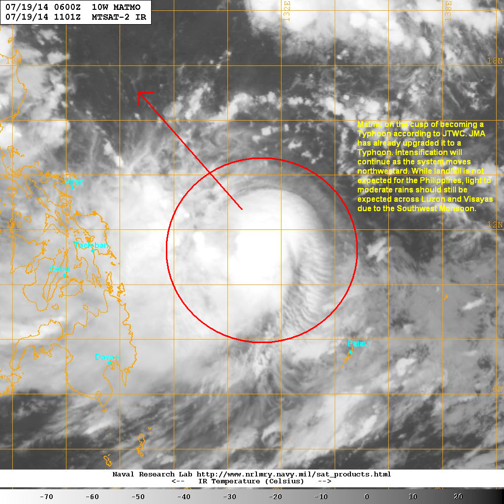
Tropical Storm Matmo (Bagyong Henry) continues to intensify and is now on the cusp of becoming a Typhoon (in fact JMA already upgraded the system to a Typhoon this afternoon). The system as last located approximately 620km northwest of Palau or about 670km east of Tacloban. Maximum sustained winds are at 110kph with gusts of up to 140kph. TS Matmo is currently moving northwestward at 20kph.
As of 5pm this afternoon, PAGASA hasn't issued any Public Storm Warning Signals for the Philippines yet.
IR image from NRLMRY
Latest satellite image shows central convection remains strong with an increasingly symmetrical CDO. An eyewall is also trying to form at the center of Matmo. However, moderate northeasterly wind shear is hampering development and limiting intensification. We expect the environment to become more conducive in the next few days.
Tropical Storm Matmo should become a Typhoon by tomorrow morning and will continue to head northwestward across the Philippine Sea. There is still some uncertainty with the forecast track as some agencies are showing a landfall in Northern Luzon while some in Taiwan. Right now, we urge everyone from Luzon to Taiwan to the Ryukyu Islands in Japan to closely monitor the progress of Matmo.
Another aspect with this cyclone is the enhancement of the Southwest Monsoon (Habagat). We expect rains to spread across Luzon and Visayas over the next few days as Tropical Storm Matmo pulls to the northwest.
Rammasun has rapidly intensified into a Category 4 Super Typhoon this afternoon and has made landfall in Hainan Island. China Meteorological Administration confirmed landfall in Wenchang with recorded winds of 180kph to 220kph! The eye of Rammasun is now moving into Leizhou Peninsula but is affecting the whole region especially Hainan Island and coastal areas of Guangdong Province.
Watch our latest Video Update below for more info.
Radar from CMA
Latest radar image from Hainan shows the eye remains perfectly symmetrical with very heavy rains in the eyewall. Winds of 160kph continue to be reported in Haikou and up to 200kph in nearby areas. These winds are catastrophic and will do significant damages to many buildings and infrastructure. Even Leizhou Peninsula is experiencing dangerous conditions with strong winds, heavy rains, and significant storm surge especially in the city of Zhanjiang.
For the latest radar images and warnings from China, please click HERE
Super Typhoon Rammasun will continue battering Hainan and Leizhou over the next 12 hours as it moves northwestward into Gulf of Tonkin. Rammasun is forecast to make landfall in Guangxi Province tomorrow afternoon and then move towards Northern Vietnam. The threat for strong winds and heavy rains will shift westward overtime.
IR Image from NOAA
Meanwhile, Tropical Storm Matmo (Bagyong Henry) continues to slowly develop as it moves slowly across the Philippine Sea. This system will continue moving northwestward over the next few days. Some agencies are expecting Matmo to become a typhoon by early next week. So far, the consensus is taking Matmo well east of the Philippines but it can still impact the country as it enhances the Southwest Monsoon.
We'll have more updates on these two Tropical Cyclones tomorrow morning.
If
you have any pictures or videos showing the impacts of Glenda in your
area, please share them with us through our Facebook Page (above) or
through our email: philippineweather@yahoo.com
Please watch our Video Update for below for the latest analysis and forecasts for Typhoon Rammasun. We are also watching a developing low pressure area east of Mindanao so be sure to watch our video for more information about that LPA.
Typhoon Rammasun (Bagyong Glenda) is now moving quickly away from the Philippines. The storm center was last located approximately 320km west northwest of Manila. Maximum sustained winds have decreased to 140kph with gusts of up to 175kph making Rammasun a Category 1 Typhoon. The system is currently moving west northwestward at 30kph. As of 5pm this afternoon, PAGASA has removed most Signal Warnings in the country. However, Public Storm Warning Signal #1 is still up for the following areas: Zambales, Tarlac, Pampanga, Bataan, Bulacan, Rizal, Cavite, Lubang Island, Pangasinan, and Metro Manila.
IR Image from NOAA
Latest satellite image shows the center of Rammasun is now moving away across the waters of the South China Sea (West Philippine Sea). There are still some residual rains moving across Southern and Central Luzon bringing light to moderate rain showers. We expect those to gradually taper off tonight and into tomorrow.
For the latest radar images, please click HERE (ClimateX PH)
Typhoon Rammasun will continue moving quickly to the northwest and should exit the Philippine Area of Responsibility by tomorrow morning (Thursday). We are also expecting the system to re-intensify as it moves across the open waters. Rammasun is forecast to move into Hainan Island by Friday afternoon and then towards Northern Vietnam by Saturday.