Showing posts with label 06W (Noul). Show all posts

Sunday, May 10, 2015

Typhoon Noul (Dodong) Update #9

Issued (0430 UTC) 1230pm PhT 051115
_________________________________

Like our FACEBOOK PAGE for the latest updates on this storm!

Typhoon Noul (Bagyong Dodong) is now rapidly weakening as it moves away from the Philippines. The center of Noul was last located approximately 130km north northeast of Basco, Batanes or about 380km south southeast of Taipei, Taiwan. Maximum sustained winds are down to 185kph with gusts of up to 230kph. Typhoon Noul is moving northward at 20kph.

As of 11am today, PAGASA has raised Public Storm Warning Signal #3 for Batanes Group of Islands. Signal #2 for Babuyan and Calayan Group of Islands. Signal #1 for Northern Cagayan.

IR Image from NRLMRY

 
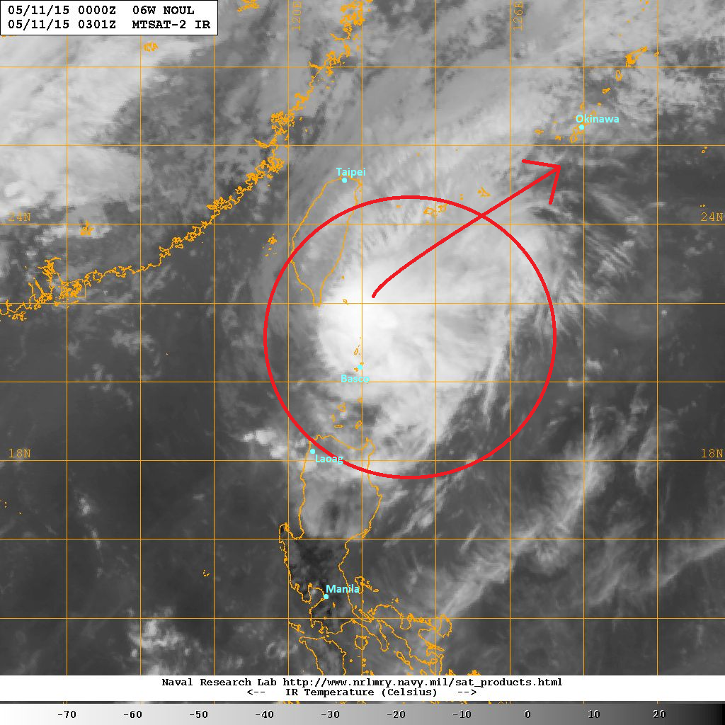
Latest satellite image shows Noul becoming much more ragged this morning. The typhoon is weakening at a fast pace as it moves into more hostile environment with drier air and increasing wind shear. However, Noul is still bringing bands of light to moderate rains across Eastern Taiwan and will linger for another 6 to 12 hours. Heavy rain advisories have been issued by the Central Weather Bureau for the threat brought by Typhoon Noul.

Typhoon Noul will continue moving northward and should turn more to the northeast today. Increasingly unfavorable conditions will lead to further weakening in the next few days. However, we expect Noul to still bring stormy conditions across the Southern Japanese Islands. Even Okinawa might still see some typhoon-force conditions by tomorrow morning (Tuesday). The Japan Meteorological Agency has already issued warnings and advisories for the impending threat and Kadena Air Base is now under TCCOR-2.

If you live in one of these islands, expect strong winds and heavy rains to commence this evening with the worst part happening tomorrow morning (especially for Okinawa). Please stay alert and always consult JMA for the latest official warnings and forecasts.

We'll have another update later this evening.

Super Typhoon Noul (Dodong) Update #8

Issued (12 UTC) 8pm PhT 051015
____________________________

Like our FACEBOOK PAGE for the latest updates on this storm! 

Super Typhoon Noul (Dodong) has maintained its strength as its eye clips the tip of Northeastern Luzon. Noul's eye is now starting to move away from Luzon and was last located 70km northeast of Aparri, Cagayan or about 200km south of Basco, Batanes. Maximum sustained winds remain at 260kph with gusts of up to 315kph. STY Noul is moving northward at 15kph.

As of 5pm this afternoon, PAGASA has issued Public Storm Warning Signal #4 for Northeastern Cagayan, Batanes, Babuyan and Calayan Group of Islands. Signal #3 for the rest of Cagayan, Isabela, and Apayao. Signal #2 for Northern Aurora, Kalinga, Mt. Province, Ifugao, Ilocos Norte, and Abra. Signal #1 for the rest of Aurora, Ilocos Sur, and Quirino.

IR Image from NRLMRY

 
Latest satellite image shows the small eye of Noul is moving very near the tip of Cagayan. Super Typhoon Noul hasn't technically made landfall. However, the western eyewall did clip land, near the town of Sta. Ana, Cagayan. We don't have any reports yet from that region, but we expect very strong winds of up to 200kph are currently affecting the NE tip of Cagayan. We expect winds to start dying down as Noul moves away to the north. Rains should also start to move away from the region.

Super Typhoon Noul will continue moving northward and will bring stormy conditions across Batanes Islands this evening. Expect dangerous conditions to last through the morning hours. Noul will then turn northeastward towards the Southern Japanese Islands and will impact the region early next week as a weakening typhoon.

We'll have another update tomorrow morning.

Saturday, May 9, 2015

Super Typhoon Noul (Dodong) Update #7

Issued (2230 UTC) 630am PhT 051015
________________________________

Like our FACEBOOK PAGE for the latest updates on this storm!  

Noul (Bagyong Dodong) has rapidly intensified overnight and is now a Category 4 Super Typhoon. The eye of Noul was last located approximately 130km northeast of Casiguran, Aurora or about 230km southeast of Aparri, Cagayan. Maximum sustained winds are now at 240kph with gusts of up to 295kph. STY Noul is currently moving northwestward at 20kph.

As of 5am this morning, PAGASA has raised Public Storm Warning Signal #3 for Cagayan, Apayao, Isabela, Babuyan and Calayan Group of Islands. Signal #2 is in effect for Northern Aurora, Kalinga, Mt. Province, Ifugao, Batanes, and Quirino. Signal #1 is up for Southern Aurora, Abra, Ilocos Sur, Ilocos Norte, Benguet, Nueva Vizcaya, and Nueva Ecija.

IR Image from NRLMRY

 
Latest satellite image shows the very symmetrical pinhole eye of Noul. The eye has gotten rounder in appearance as strong convective banding tightened and become more organized overnight. The recent intensification is due to the weak wind shear, excellent radial outflow, and warm sea temperatures. Noul could intensify even more in the next 6 hours before it clips the province of Cagayan.

Radar Image from DOST-PAGASA

 
The satellite image and the radar image above both show rainclouds associated with Noul are now affecting parts of Northern Luzon, particularly the provinces of Aurora, Isabela, and Cagayan. We expect nearby provinces to start feeling the effects of Noul later this morning. However, the heaviest rains and strongest winds will be confined along the coasts of Cagayan, Isabela, and perhaps Apayao. Up to 200m of rain is possible in these areas which could lead to landslides and flash floods. Aside from the heavy rains, high surf and the threat of storm surge should be expected along the coast of Cagayan.

Please consult with your local officials for the latest warnings and advisories for your area. Click HERE for the latest radar images and forecasts from PAGASA (Project NOAH)

Super Typhoon Noul (Bagyong Dodong) will continue moving northwestward and is expected to clip the northeastern part of Cagayan (near Sta. Ana). The good news is that the heaviest rains and strongest winds will be limited to a small area in Northeastern Luzon. Damaging winds of up to 200kph may be felt along the coast in Cagayan and weaker winds elsewhere. However, the entire region should still be prepared for the stormy conditions that will prevail throughout today.

We'll have another update later today.

Typhoon Noul (Dodong) Update #6

Issued (1230 UTC) 830pm PhT 050915
_________________________________

Like our FACEBOOK PAGE for the latest updates on this storm! 

Typhoon Noul (Bagyong Dodong) has intensified this afternoon as it moves closer to the island of Luzon. The eye of Noul was last located approximately 270km east southeast of Casiguran, Aurora or about 390km east northeast of Manila. Maximum sustained winds are now up to 195kph with gusts of up to 230kph making Noul a Category 3 Typhoon. Noul is currently moving northwestward at 20kph.

As of 5pm this afternoon, PAGASA has issued Public Storm Warning Signal #3 for Cagayan, Isabela, and Northern Aurora. Signal #2 for Calayan and Babuyan Groups of Islands, Apayao, Kalinga, Mt. Province, Nueva Vizcaya, Ifugao, Rest of Aurora, Polilio Island, Catanduanes, and Quirino. Signal #1 for Batanes, Abra, Ilocos Sur, Ilocos Norte, Benguet, Nueva Ecija, Quezon, Camarines Norte, and Camarines Sur.

IR Image from NRLMRY


Latest satellite image shows a pinhole eye has formed surrounded by strong and deep convective activity. Noul has been able to intensify as wind shear has weakened and upper-level patterns has led to the typhoon developing excellent radial outflow. Slight intensification is possible through the evening hours before it makes landfall in Cagayan tomorrow morning.

Radar Image from Baler (PAGASA)

 
Latest radar image out of Baler, Aurora shows outer rain bands from Typhoon Noul are now making their way towards the coast of Northern Luzon. Provinces of Isabela, Aurora, Quirino, and Quezon are starting to see light rains. We expect these rain bands to continue spreading northward eventually reaching Cagayan and nearby provinces. Rainfall amounts of up to 300mm are possible especially in mountainous areas. Landslides and flashfloods are possible especially in usually threatened areas. Please consult with your local officials for the latest warnings and advisories for your area.

For the latest radar images and forecasts from PAGASA, please click HERE (PROJECT NOAH)

Typhoon Noul (Bagyong Dodong) will continue moving northwestward and will eventually make landfall in the province of Cagayan. However, strong typhoon winds may still be felt as far as the province of Isabela. Furthermore, heavy rains will spread across Northern Luzon and will linger through the afternoon hours. Noul will exit early but will still impact the islands of Babuyan before moving northeastward towards the Japanese Islands.

We'll have another update tomorrow morning.

Friday, May 8, 2015

Typhoon Noul (Dodong) Update #5

Issued (12 UTC) 8pm PhT 050815
_____________________________

Like our FACEBOOK PAGE for the latest updates on this storm!

Typhoon Noul (Bagyong Dodong) has maintained its intensity as it moves closer to the Philippine Islands. The eye of Noul was last located approximately 400 east northeast of Catarman, Northern Samar or about 440km east southeast of Virac, Catanduanes. Maximum sustained winds remain at 165kph with gusts of up to 205kph. Typhoon Noul is moving west northwestward at 20kph.

As of 5pm this afternoon, PAGASA has placed the province of Catanduanes under Public Storm Warning Signal #2. Meanwhile, Signal #1 is in effect for Sorsogon, Albay, Camarines Norte, Camarines Sur, Quezon, Polilio Island, Aurora, Quirino, Isabela, Northern Samar, and Eastern Samar.

IR Image from NRLMRY

 
Latest satellite image shows the central dense overcast remaining strong and and organized. Noul struggled to intensify due to the presence of dry air and a slight increase in wind shear. However, the system looks like it is recovering and could intensify a little bit more in the next 24 to 36 hours before it makes landfall in Luzon.

The image above also shows the potential track Noul may take. Please note THIS IS NOT OFFICIAL! However, the current track is supported by numerous computer model outputs, as well as tracks from different weather agencies in the region.

Typhoon Noul will continue moving west northwestward, passing near the island of Catanduanes tomorrow morning (Saturday). It will continue its trek, intensifying along the way and possibly becoming a Category 3 typhoon. By Sunday morning, Noul is forecast to make landfall either in the province of Isabela or in Cagayan. Strong winds, heavy rains, and high waves should be expected along the eastern coast of Luzon, especially in the northern provinces. 

If you live along the areas in Northern Luzon forecast to be hit by Noul, please start your preparations now. Always consult with your local officials for the latest warnings and orders specific to your area. Stay safe!

Wednesday, May 6, 2015

Typhoon Noul (Dodong) Update #4

Issued (0330 UTC) 1130am PhT 050715
_________________________________

Like our FACEBOOK PAGE for the latest updates on this storm!  

Typhoon Noul (Bagyong Dodong) continues to intensify as it moves across the Philippine Sea. The center of Noul was last located approximately 400km north northwest of Palau or about 860km east of Guiuan, Eastern Samar. Maximum sustained winds are now at 165kph with gusts of up to 205kph. Typhoon Noul is currently moving west northwestward at 15kph.


IR Image from NRLMRY


Latest satellite image shows strong convective activity continue in and around the circulation center. An eye is also beginning to form and could become more pronounced later today. Good outflow pattern and high ocean heat content will promote steady intensification for another 48 hours which could help Noul attain Category 4 intensity this weekend.

Forecast Track (NOT OFFICIAL!)

 
Computer models continue to shift their track westward and our latest forecast map reflects that change. Unfortunately, the chances of landfall in Luzon are increasing as the turn to the north is not forecast to happen until after Noul makes landfall on Sunday.

Right now, the center of Noul may make landfall in the Central Luzon region around Sunday morning (PH Time). However, parts of Eastern Visayas (especially Samar Island) and Bicol Region are also poised to see direct impacts from Noul beginning Saturday morning. Strong winds, heavy rains, and high surf should be expected along the eastern coast of Luzon and Visayas this weekend.

If you live in the areas near our forecast track, now is the time to start your preparations. Please note that this Forecast Track is not official and may change in the coming days. Please consult PAGASA and your local officials for the latest forecasts and warnings for your area. Stay safe!

Tuesday, May 5, 2015

Tropical Storm Noul Update #3

Issued (03 UTC) 11am PhT 050615
_____________________________

Like our FACEBOOK PAGE for the latest updates on this storm!  

Tropical Storm Noul continues to intensify as it moves away from the island of Yap. The storm center was last located approximately 100km west of Yap or about 360km northeast of Palau. Maximum sustained winds are now at 110kph with gusts of up to 140kph. TS Noul is currently moving westward at 10kph.

IR Image from NRLMRY

 
Latest satellite image shows the central dense overcast becoming more symmetrical this morning. Spiral banding also continues to improve and radial outflow remains excellent. Favorable conditions exist and will allow for continued intensification. Noul is expected to become a typhoon later this afternoon.

As for Yap, weather conditions are forecast to improve today. Winds of up to 100kph and continuous heavy rains were reported in the island last night during the height of the storm.

Forecast Track (NOT OFFICIAL!)

 
There has been little change in our forecast track for Noul. Computer models have held steady, if not shift left, with their respective tracks. We still expect Noul to continue its west northwestward movement over the next few days. It will enter the Philippine Area of Responsibility and will be given the local name 'Bagyong Dodong' by PAGASA.

Based on the current computer model consensus and analysis of atmospheric conditions in the Pacific, Noul will be taking a northward turn this weekend. However, the timing of this northward turn will be crucial as it will eventually determine how close Noul will get to the Philippines.

Our current track and forecast philosophy is aligned more to the west-based camp and therefore, is showing a possible landfall in Northern Luzon by Sunday. However, please note that our confidence in this track is still low at this point. We hope to have more confidence in the next 24 to 48 hours when we see more consensus and consistency in the computer model outputs.

Either way, we want to stress the potential threat that this system may bring to the Philippines. We advise residents, especially in Eastern Visayas, Bicol Region, and Northern Luzon to pay close attention in the coming days with regard to Tropical Storm Noul's movement and forecast track.

Monday, May 4, 2015

Tropical Storm Noul Update #2

Issued (03 UTC) 11am PhT 050515
_____________________________

Like our FACEBOOK PAGE for the latest updates on this storm! 

Tropical Storm Noul continues to intensify as it nears the State of Yap. The center of Noul was last located approximately 80km east of Yap or about 540km northeast of Palau. Maximum sustained winds are now at 95kph with gusts of up to 120kph. TS Noul is currently moving westward at 10kph.

The National Weather Service has now issued a Typhoon Warning for Yap Island and Tropical Storm Warning for Fais and Ulithi. Residents are advised to complete their preparations for the impending storm. The agency is expecting winds of more than 120kph (74mph) beginning later tonight and lasting through Wednesday morning (local time). Aside from strong winds, heavy rains and high surf are also expected to linger over the next 12 to 24 hours.

For the latest updates and warnings from NWS Guam, please click HERE

IR Image from NRLMRY


Latest satellite image shows strong convection forming around the center of circulation. Tight banding is observed through microwave imagery with an eye beginning to be discernible as it wraps around Noul's center. The system is currently in an area of low to moderate wind shear and good outflow which will promote steady intensification over the next few days.

Forecast Track (NOT OFFICIAL!)


Tropical Storm Noul will continue moving slowly westward and will strike the island of Yap later tonight. Prolonged stormy conditions will increase the potential for wind damage as well as that from flooding and storm surge. The island will see improving weather conditions tomorrow afternoon (Wednesday).

Noul is forecast to enter the Philippine Area of Responsibility by Thursday morning and will be given the local name 'Bagyong Dodong' by PAGASA. Computer models are starting to converge on a track that will see Noul move in a steady west-northwest trajectory in the coming days. Favorable weather conditions will allow for steady intensification as Noul moves across the Philippine Sea. By Saturday, the storm is forecast to turn northward but this turn will be key as to how close it will get to the Philippine Island.

Our preliminary forecast is based on the consensus from the latest computer model outputs of this morning. Right now, there is a moderate chance that the island of Luzon will see direct impacts from Noul this weekend. Obviously, this forecast track will change many more times in the coming days but we want to highlight the potential for a stormy weather this coming weekend especially for Northern Luzon.

We'll have another update later this evening.

Sunday, May 3, 2015

Tropical Storm Noul Update #1

Issued (2230 UTC) 630am PhT 050415
________________________________

Like our FACEBOOK PAGE for the latest updates on this storm! 

A new Tropical Cyclone has formed this morning near the Mariana Islands. Tropical Storm Noul, the sixth named storm this year, was last located approximately 270km east of Yap or about 600km southwest of Guam. Maximum sustained winds are at 65kph with gusts of up to 85kph. TS Noul is moving west northwestward at 10kph.

The National Weather Service in Guam has issued a Tropical Storm Watch for Yap. Residents are advised to begin preparations for the oncoming storm. Heavy rains and strong winds are possible for the state of Yap beginning later this afternoon and lasting into Tuesday.

IR Image from NRLMRY


Latest satellite image shows strong convective activity developing in and around the circulation center. Noul is located in an area of low wind shear and warm sea surface temperatures which should help it intensify even further in the coming days.

Tropical Storm Noul will continue moving generally west northwestward and will start impacting the state of Yap later this afternoon. Stormy conditions are forecast to last through tomorrow (Tuesday). The system will then west northwestward entering the Philippine Area of Responsibility by Wednesday evening and will be given the local name 'Bagyong Dodong' by PAGASA. Right now, it is still too early to tell whether Noul will directly impact the Philippines or not.