Tropical Storm Halong continues to battle strong wind shear as it moves across the Philippine Sea. The system was last located approximately 600km west northwest of Guam. Maximum sustained winds are at 95kph with gusts of up to 120kph. TS Halong is moving westward at 15kph.
IR Image from NRLMRY
Latest satellite image shows convection remains strong, especially along the southern flank. Halong exhibited improvements last night with an expanding central dense overcast and banding around the center. However, wind shear increased again this morning leaving the northern half struggling for development. Nevertheless, we still expect Halong to recover and resume intensification in the next few days.
Forecast Track (NOT OFFICIAL!)
Tropical Storm Halong is forecast to continue moving across the Philippine Sea over the next few days. It will turn more to the northwest as the sub-tropical ridge weakens. Environmental conditions will become more favorable and should allow Halong to reach Typhoon-strength this weekend. Latest computer model runs put Halong near the Japanese Islands by the middle part of next week.
We'll have another update on Halong and Nakri later this afternoon.
Tropical Storm Halong is starting to show some improvements today as wind shear weakens in the region. The storm was last located approximately 480km west northwest of Guam or about 540km west of Saipan. Maximum sustained winds remain at 85kph with gusts of up to 110kph. TS Halong is moving west northwestward at 20kph.
IR Image from NRLMRY
Latest satellite image shows convective activity has increased and become more expansive. The low-level center which was fully exposed earlier this morning is now under the cloud canopy, suggesting that the upper-level winds are finally starting to relax. We could see further intensification happen tonight.
Tropical Storm Halong will continue moving west northwestward across the Philippine Sea over the next few days. It will then start turning more to the northwest and then to the north by early next week. Long-range forecasts suggest that Halong may impact the Japanese Islands by the middle part of next week.
Tropical Storm Nakri is a monsoon depression that has been spinning across the Philippine Sea over the past 2 days. The Japan Meteorological Agency and other agencies in the region, with the exception of the Joint Typhoon Warning Center, are giving warnings and bulletins on this system. Nakri was last located approximately 100km southwest of Okinawa. Maximum sustained winds are at 75kph with gusts of up to 95kph. TS Nakri is moving north northwestward at 20kph.
IR Image from NRLMRY
Nakri, being a monsoon depression, has a very large circulation and an expansive wind field. The system also has very little convection near the circulation center. Its strong winds can be felt as far as 400km away from the center. Due to its large nature, Nakri isn't really intensifying that quickly despite the favorable conditions in the region.
Radar Image from JMA
Latest radar out of Okinawa shows scattered light rain showers. Much of the convection is still located south of the circulation and should impact the Japanese Islands by tomorrow. For the latest radar images and cyclone information from Japan, please click HERE (JMA Website)
Tropical Storm Nakri will continue moving generally northward into the East China Sea. We expect very little intensification but its large circulation will affect parts of Eastern China and Ryukyu Islands. By early next week, the system could move into the Korean Peninsula bringing rains and strong winds in the region.
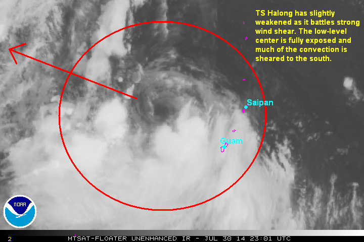
Tropical Storm Halong has slightly weakened as it struggles with strong upper-level winds. The system was last located approximately 340km northwest of Guam or about 380km east of Saipan. Maximum sustained winds are at 85kph with gusts of up to 110kph. TS Halong is moving west northwestward at 15kph.
IR Image from NOAA
Latest satellite image shows the low-level center of Halong has been fully exposed as the system battles strong upper-level winds. Much of the strong convective activity is being relegated to the southern half of the circulation. We expect the wind shear to relax in the next few days which should allow Halong to resume intensifying.
Forecast Track (NOT OFFICIAL!)
Tropical Storm Halong will continue moving west northwestward over the next few days and should resume intensifying as environmental conditions become more favorable for development. Long-range forecasts show Halong intensifying perhaps into a Category 2 Typhoon by early next week. It could also pose a threat to the Japanese Islands in the next 3 to 5 days.
Tropical Storm Halong has maintained its intensity as it begins to move away from the Mariana Islands. The system was last located approximately 120km west northwest of Guam or about 220km southwest of Saipan. Maximum sustained winds are at 95kph with gusts of up to 120kph. TS Halong is moving west northwestward at 15kph.
As of 6pm (PhT) today, the National Weather Service has canceled all Typhoon and Tropical Storm Warnings for the Mariana Islands. However, residents are still advised against going to the water due to the high waves churned by TS Halong. Please heed the latest updates and warnings from your local officials.
IR Image from NRLMRY
Latest satellite image shows little change with Halong's organization. The system seems to be struggling from increasing vertical wind shear and the poor upper-level environment created by Tropical Storm Nakri (Bagyong Inday) to the northwest. With that said, we still think Halong will intensify as it moves across the Philippine Sea over the next few days.
Radar Image from Guam
Latest radar image out of Guam courtesy of the National Weather Service shows that the bands of light to moderate rains are now moving away from the Mariana Islands. The center of Halong also continues to be picked up by radar and remains fully intact despite the weakening trend we saw this afternoon. Rainfall reports across Guam and nearby islands ranged from 100 to 150mm. We expect weather conditions to continue improving.
For the latest radar images and warnings for the Marianas, please click HERE (NWS Website)
Tropical Storm Halong will continue moving west northwestward over the next few days. As Tropical Storm Nakri (Inday) moves to the north, upper-level environment will become more conducive which should allow Halong to re-intensify as it moves across the Philippine Sea. Right now, Halong is not forecast to directly impact and land areas in the next 3 days.
Tropical Storm Halong has intensified even further as it nears the Mariana Islands. The system was last located approximately 70km northeast of Guam or about 140km south southwest of Saipan. Maximum sustained winds are at 95kph with gusts of up to 120kph. TS Halong is moving west northwestward at 15kph.
As of 8am this morning, the National Weather Service has issued a Typhoon Warning for Rota while a Typhoon Watch is in effect for Guam. A Tropical Storm Warning is also issued for Guam, Tinian, and Saipan. Areas mentioned here will continue experiencing stormy conditions with strong winds and heavy rains. Please heed the warnings of your local officials; stay safe!
IR Image from NRLMRY
Latest satellite image suggests that Halong may have stopped intensifying, temporarily. The central dense overcast that was present overnight is no longer as well defined this morning. Furthermore, it seems the system is battling moderate northerly wind shear. Nevertheless, the core remains fully intact and we are still expecting Halong to resume intensification later today.
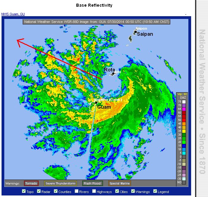
Radar Image from Guam
Latest radar image out of Guam courtesy of the National Weather Service shows bands of light to moderate and even pockets of heavy rain affecting the islands. So far, Guam Airport has already recorded nearly 120mm of rain since last night. We're expecting up to 200mm of rain in some places which may lead to flooding in low-lying areas.
For the latest radar images and warnings for the Marianas, please click HERE (NWS Website)
Forecast Track (NOT OFFICIAL!)
Tropical Storm Halong will continue moving westward this morning, passing between the islands of Guam and Rota. Strong winds and heavy rains will persist through the afternoon hours. We are also expecting Halong to resume intensification and could still become a Typhoon by tomorrow. Favorable conditions along the forecast path will lead to further intensification which could lead to Halong becoming a Category 3 Typhoon over the Philippine Sea later this week.
Tropical Depression 11W continues to rapidly intensify and is now Tropical Storm Halong. The system was last located approximately 290km southeast of Saipan or about 320km east of Guam. Maximum sustained winds are now at 85kph with gusts of up to 110kph. TS Halong is moving northwestward at 15kph.
The National Weather Service has now issued a Typhoon Warning for Rota. A Typhoon Watch is in effect for Guam. While a Tropical Storm Warning is in effect for Guam, Tinian, and Saipan. Please follow the warnings of your local officials!
IR Image from NRLMRY
Latest satellite image shows Halong continuing to consolidate with strong convective banding wrapping around the center. Equatorward outflow remains excellent and overall environment remains conducive for further intensification. As the system moves closer to the islands, stronger winds are being reported across Guam. Winds of up to 50kph (30mph) are already being felt and will only increase as the night goes on.
Radar Image from Guam
Latest radar image from Guam shows bands of light to moderate rains moving across the island. These rain showers will continue to spread into the nearby islands tonight and into tomorrow. A developing eye can also be seen from the radar image above supporting the intensity estimates based on satellite imagery.
For the latest radar images and warnings for Guam, please click HERE (NWS Website)
Tropical Storm Halong will continue intensifying as it moves closer to the Mariana Islands. Based on current trends, the system could become a Typhoon by tomorrow as it moves near the island of Rota. Winds of up to 100kph and rainfall amounts of up to 100mm are possible across Guam, Saipan, and nearby islands. Please prepare and heed the warnings of your local officials!
A new Tropical Cyclone has developed over the Western Pacific this morning. Tropical Depression 11W was last located approximately 430km east southeast of Guam or about 450km southeast of Saipan. Maximum sustained winds are at 55kph with gusts of up to 75kph. TD 11W is moving northwestward at 10kph.
As of 8am this morning, the National Weather Service has issued a Tropical Storm Watch for Guam, Rota, Tinian, and Saipan. This Watch is for the potential for Tropical Storm conditions within the next 48 hours. Residents are advised to take precautionary measures and to always stay on top of the news and warnings from your local officials.
IR Image from NRLMRY
Latest satellite image shows a rapidly developing cyclone with convective banding wrapping around a broad low-level circulation center. Radial outflow is also good and has been instrumental with the recent improvement in the organization of TD 11W. Outer bands are also starting to move into the Marianas Islands and the areas there, including Guam, could start seeing light rains later this afternoon.
Forecast Track (NOT OFFICIAL!)
Tropical Depression 11W is located in an area with weak steering environment. It will be moving slowly northwestward over the next few days. It will move between Guam and Saipan by tomorrow (Wednesday) as a possible Tropical Storm. TD 11W will also be moving across favorable area and could become a Typhoon later this week as it moves into the Philippine Sea. After the Mariana Islands, we have little confidence on where this system will eventually end up. We'll keep updating our forecasts as soon as we get more information.
Tropical Depression Matmo is now rapidly weakening as it moves across Eastern China. The system was last located approximately 230km northwest of Fuzhou or about 480km southwest of Shanghai. Maximum sustained winds are at 55kph with gusts of up to 75kph. TD Matmo is moving north northwestward at 25kph.
IR Image from NRLMRY
Latest satellite image shows Matmo decaying rapidly now as it continues to interact with land. The circulation is still intact but convective banding is suffering and is no longer well-developed. Despite this, however, some areas are still reporting gusty winds of up to 100kph. We should see continued weakening through the day, with total dissipation expected by tomorrow.
Radar Image from CWB
Latest satellite image shows widespread rains affecting the provinces of Fujian, Jiangxi, Zhejiang, and Anhui. Many areas are already reporting well over 200mm of rainfall and we could still up to 100mm fall through the next 24 hours. Flooding and landslides are still possible in this region as we head into the latter part of this week.
For the latest Radar Images and Weather Warnings from China, please click HERE (CMA Website).
Meanwhile, a plane crash in Taiwan is attributed to foul weather caused by Matmo as it moved across yesterday. So far, authorities estimate at least 40 people are killed because of the crash.
Tropical Depression Matmo will continue weakening today and should completely dissipate my tomorrow. Rains will continue across Eastern China and could also affect Shanghai by tomorrow. This will be the final update for Matmo.
Matmo (Formerly Bagyong Henry) has made its second and final landfall in Fujian Province in Southeastern China. It has also weakened to a Tropical Storm as it interacts with land. The system was last located approximately 40km south of Fuzhou or about 230km west northwest of Taipei. Maximum sustained winds are at 100kph with gusts of up to 130kph. TS Matmo is moving northwestward at 15kph.
IR Image from NRLMRY
Latest satellite image shows Matmo moving inland into Southeastern China. The storm is still looking symmetrical with convective bands surrounding the circulation center. Strong winds continue to be present near the center, as well. Some coastal areas along Fujian have reported seeing gusts of up to 150kph.
Winds in Taiwan are now subsiding but they will still experience light to moderate rains, especially along the western coast. Many areas here, especially Hualien County received 300 to 500mm of rain over the past 48 hours which caused landslides and flooding in many areas.
Radar Image from CMA
As Matmo move ashore in Fujian, widespread light to moderate rains are now affecting the area including nearby provinces of Zhejiang and Jiangxi. We expect 200 to as much as 500mm of rainfall in many places in Eastern China over the next few days and this heavy rainfall event can cause flooding and landslides, as we've seen in Taiwan.
For the latest warnings and forecasts from China, please click HERE (CMA Website)
Tropical Storm Matmo will continue moving inland tonight bringing rains and strong winds in the region. It should also rapidly weaken as it interacts with land. Rains will linger across Eastern China for the next 2 to 3 days.
Typhoon Matmo (Bagyong Henry) is now moving into Taiwan Strait after making landfall in Taiwan last night. The system was last located approximately 150km southwest of Taipei, Taiwan or about 200km southeast of Fuzhou, China. Maximum sustained winds have weakened to 120kph with gusts of up to 150kph. Typhoon Matmo is moving northwestward at 20kph.
IR Image from NRLMRY
Latest satellite image shows the core of Matmo now moving into Taiwan Strait. Matmo made landfall in Taitung County just before midnight last night as a Category 2 Typhoon. It crossed the mountainous regions of Taiwan which significantly disrupted the circulation, leading to the weakening this morning.
Radar Image from CWB
Latest radar image out of Taiwan shows that there are still bands of moderate to heavy rains affecting the region. Up to 500mm of rainfall has already been recorded in some areas, especially in Hualien County. Numerous landslides and flooding events have already been reported and we will likely see more reports later today. We're expecting anywhere from 100 to as much as 300mm to fall throughout the next 12 hours.
For the latest radar images and warnings from Taiwan, please click HERE (CWB Website)
Typhoon Matmo is forecast to make landfall in Fujian Province later this afternoon and will move near the city of Fuzhou. Typhoon-force winds of up to 150kph are still possible along with the threat of storm surge along the coast. Heavy rains will also be affecting the provinces of Fujian, Zhejiang, and Jiangxi later today. Eastern China might see up to 300mm of rain over the next 24 hours.
Please watch our Video Update below for the latest in-depth analysis and forecast for Typhoon Matmo.
Typhoon Matmo (Bagyong Henry) has slightly intensified as it moves ever closer to Taiwan. The system was last located approximately 230km north northeast of Basco, Batanes or about 300km south southeast of Taipei, Taiwan. Maximum sustained winds are at 155kph with gusts of up to 195kph making Matmo a Category 2 Typhoon on the Saffir-Simpson Scale. Matmo is currently moving north northwestward at 25kph. PAGASA has issued Signal #2 for Batanes Group of Islands and Signal #1 for Calayan and Babuyan Islands. Meanwhile, Central Weather Bureau in Taiwan has issued a Sea and Land Typhoon Warning for the entire region. Extremely Heavy Rain Advisories have also been issued across the counties in Taiwan. Please heed the warnings of your local officials and stay safe!
Radar Image from CWB
Latest radar image from Central Weather Bureau shows the eye of Matmo moving closer to Taiwan. Bands of light to moderate rains are already affecting Taitung and Hualien Counties. Heavy rains will continue moving from the east and will encompass the entire island by tonight. We expect anywhere from 300 to 500mm of rain to fall in the next 24 hours. Some locations may see up to 800mm which will bring widespread landslides and flooding across the low-lying areas.
For the latest radar images and warnings from Taiwan, please click HERE (CWB Website)
Typhoon Matmo will exit into the Taiwan Strait by tomorrow morning (Wednesday) and will make landfall in Fujian Province in China by tomorrow afternoon. It will rapidly weaken as it moves further inland into China but it will still bring widespread rains in the region.
Watch our latest Video Update below for the complete analysis and forecasts for Typhoon Matmo.
Typhoon Matmo (Bagyong Henry) continues to track closer towards Taiwan. The storm center was last located approximately 460km east of Aparri, Cagayan or about 850km southeast of Taipei, Taiwan. Maximum sustained winds remain at 130kph with gusts of up to 165kph. Typhoon Matmo is moving north northwestward at 30kph. As of 5pm this afternoon, PAGASA has issued Public Storm Warning Signal #2 for Batanes Group of Islands. Signal #1 for Cagayan, Calayan and Babuyan Group of Islands.
IR Image from NRLMRY
Latest satellite image continues to show improvements with convection wrapping around the center now. The central dense overcast is also more symmetrical this afternoon. The wind shear continues to weaken and this is allowing Matmo to finally improve its structure. We'll likely see intensification occur tonight and continue into tomorrow morning.
Cagayan Province and the islands north of Luzon will be dealing with some scattered light to moderate rains and gusty winds. The center will move near the Batanes Islands tomorrow morning and we expect stormy conditions to occur there.
Typhoon Matmo is forecast to make landfall in Northern Taiwan by tomorrow afternoon and then move near Taipei by the evening. Strong winds of up to 160kph are possible along with heavy rains of up to 500mm. Flooding and landslides, especially in mountainous regions, are possible.
Matmo is, then, forecast to move into Eastern China bringing the same threat there later this week.
Typhoon Matmo (Bagyong Henry) maintains strength as it moves east of Luzon. The system was last located approximately 520km east northeast of Casiguran, Aurora or about 1,020km southeast of Taipei, Taiwan. Maximum sustained winds are still at 130kph with gusts of up to 165kph. Typhoon Matmo is moving north northwestward at 20kph.
IR Image from NRLMRY
Latest satellite image suggest that Typhoon Matmo may be starting to show signs of intensification again. The convective activity remains but it also appears that the eyewall may be starting to take shape. We could see an eye form later this afternoon. The wind shear has weakened slightly and the warm waters of the Philippine Sea should help fuel intensification.
Scattered light to moderate rains will continue to impact Luzon today. The rains will be heavier across Northern Luzon, particularly in the provinces of Cagayan and Isabela. For the latest radar images from the Philippines, please click HERE (ClimateX PH)
Typhoon Matmo will continue moving north northwestward. We should see intensification continue over the next 24 to 36 hours. Current forecasts shows Matmo moving towards Taiwan by Tuesday morning as a possible Category3 Typhoon. Heavy rains, strong winds, and the storm surge will be threatening Taiwan as the system moves ashore.
Typhoon Matmo (Bagyong Henry) has maintained its strength as it moves across the Philippine Sea. The center of the storm was last located approximately 500km northeast of Virac, Catanduanes or about 760km east northeast of Manila. Maximum sustained winds are at 130kph with gusts of up to 165kph. Typhoon Matmo is currently moving north northwestward at 20kph. As of 5am this morning, PAGASA has issued Public Storm Warning Signal #1 for Batanes Group of Islands, Cagayan, Babuyan and Calayan Group of Islands.
IR Image from NRLMRY
Latest satellite image shows cold convective cloud tops covering much of Matmo's circulation. However, as intense as the satellite image may seem, further analysis suggest that this cyclone is still struggling to develop its core. The eyewall is not even formed yet and the low-level center is badly sheared from the main convection. This is suggesting that Matmo is still battling strong wind shear and is not intensifying as fast as we were forecasting it to be.
The satellite image above also shows clouds moving into Luzon and Visayas. We're expecting light to moderate rains to impact the area, especially along the eastern coast. Bicol, Quezon, Catanduanes, Samar, and nearby provinces should expect 50 to 100mm of rain today. Even Metro Manila will see some scattered rains.
Forecast Track (NOT OFFICIAL!)
Typhoon Matmo will continue moving north northwestward across the Philippine Sea over the next 2 days. We are still expecting the vertical wind shear to weaken which should allow Matmo to intensify even more. Right now, we are forecasting the system to make landfall in Taiwan as a strong Category 3 Typhoon by Wednesday morning--in line with the forecasts of other agencies in the region.
Despite not making landfall in the Philippines, Luzon and Visayas will continue to see light to moderate rains over the next few days which may cause flooding and landslides in prone areas. The northeastern part of Luzon and the islands of Batanes may also see some strong winds and heavy rains as the center of Matmo moves near the area by Wednesday.
Tropical Storm Rammasun is now rapidly dissipating over Northern Vietnam. The storm center was last located approximately 160km north of Hanoi, Vietnam. Maximum sustained winds are at 75kph with gusts of up to 95kph. TS Rammasun is moving west northwestward at 20kph.
IR Image from NOAA
Latest satellite image shows Rammasun quickly unraveling as it traverses Northern Vietnam. The circulation is rapidly dissipating with central convection rapidly deteriorating. Rain bands are still present, however, and will likely linger in the region for another 24 to 48 hours.
Radar Image from CMA
Latest radar image out of Southwestern China shows bands of light to moderate rains are still affecting Yunnan and Guangxi Provinces. Many areas are still reporting 50mm of accumulation to as much as 100mm. Winds of 60 to 80kph are also still being felt in some locations.
For the latest radar images and weather warnings for China, please click HERE (CMA Website)
Tropical Storm Rammasun has killed at least eight (8) people in China and another 70+ people in the Philippines. Thankfully, this system is now dissipating over land.
This will be the final warning for Tropical Storm Rammasun.
We'll have the latest update on Typhoon Matmo tomorrow morning.
Watch our latest Video Update below for more in-depth analysis and forecast for Tropical Storm/Typhoon Matmo.
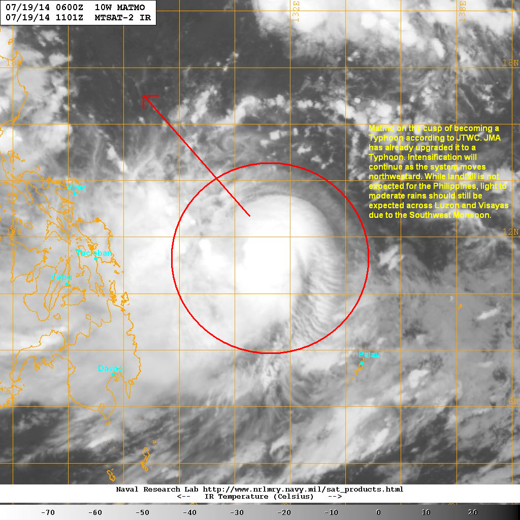
Tropical Storm Matmo (Bagyong Henry) continues to intensify and is now on the cusp of becoming a Typhoon (in fact JMA already upgraded the system to a Typhoon this afternoon). The system as last located approximately 620km northwest of Palau or about 670km east of Tacloban. Maximum sustained winds are at 110kph with gusts of up to 140kph. TS Matmo is currently moving northwestward at 20kph.
As of 5pm this afternoon, PAGASA hasn't issued any Public Storm Warning Signals for the Philippines yet.
IR image from NRLMRY
Latest satellite image shows central convection remains strong with an increasingly symmetrical CDO. An eyewall is also trying to form at the center of Matmo. However, moderate northeasterly wind shear is hampering development and limiting intensification. We expect the environment to become more conducive in the next few days.
Tropical Storm Matmo should become a Typhoon by tomorrow morning and will continue to head northwestward across the Philippine Sea. There is still some uncertainty with the forecast track as some agencies are showing a landfall in Northern Luzon while some in Taiwan. Right now, we urge everyone from Luzon to Taiwan to the Ryukyu Islands in Japan to closely monitor the progress of Matmo.
Another aspect with this cyclone is the enhancement of the Southwest Monsoon (Habagat). We expect rains to spread across Luzon and Visayas over the next few days as Tropical Storm Matmo pulls to the northwest.
Tropical Storm Matmo (Bagyong Henry) continues to intensify steadily as it moves across the Philippine Sea. The system was last located approximately 580km northwest of Palau or about 620km east of Tacloban City. Maximum sustained winds are now up to 100kph with gusts of up to 130kph. Tropical Storm Matmo is currently moving westward at 25kph.
IR Image from NRLMRY
Latest satellite image shows the central dense overcast continuing to develop with strong convective activity and formative banding around the center. There is still some northeasterly shear that is limiting the rate of intensification. However, further analysis suggests that an eyewall may already be forming and that system could intensify at a faster pace over the next few days.
Forecast Track (NOT OFFICIAL!)
There has been a significant change with our forecast track. Since Matmo intensified quickly last night, it moved farther to the west than we initially anticipated. This has led to our forecast track being adjusted to the left and is now taking Matmo (Henry) closer to the Philippine coast. However at this point, we still don't think the storm will make landfall in the country.
Nevertheless, light to moderate rains may continue impacting Visayas and parts of Luzon and Mindanao over the next few days. Matmo will also intensify throughout the forecast and could undergo a period of rapid intensification in the next 2 to 3 days. Our long-range forecast is currently showing a track towards Taiwan by middle part of next week.
Typhoon Rammasun has made landfall in Guangxi Province in Southwestern China and is currently bringing strong winds and heavy rains. The system was last located approximately 100km southwest of the city of Nanning or about 230km northeast of Hanoi, Vietnam. Maximum sustained winds are down to 185kph with gusts of up to 230kph. Typhoon Rammasun is currently moving west northwestward at 30kph.
IR Image from NOAA
Latest satellite image shows Rammasun moving over land into Guangxi Province. The eye is no longer visible but the central dense overcast remains strong and symmetrical. The eye made landfall near Beihai earlier this morning bringing winds close to 200kph. Significant storm surge and heavy rains are also affecting the region. Latest reports from the region say extensive damage along the coast along with widespread flooding in many areas.
Radar Image from CMA
Latest radar image out of Guangxi shows the extent of Rammasun's rain bands. Hainan and parts of Guangdong are still reporting light to moderate rains this morning. Closer to the center. winds of up to 180kph along with rainfall accumulations of 250mm continue to be reported. We expect these stormy conditions to last for the next 6 hours.
For the latest radar images and warnings from China, please click HERE (CMA Website)
Rammasun should rapidly weaken now that it is moving over land. However, dangerous conditions will still linger for the next 2 days. Stormy weather will start impacting Northern Vietnam, including Hanoi, later this afternoon.
Rammasun has rapidly intensified into a Category 4 Super Typhoon this afternoon and has made landfall in Hainan Island. China Meteorological Administration confirmed landfall in Wenchang with recorded winds of 180kph to 220kph! The eye of Rammasun is now moving into Leizhou Peninsula but is affecting the whole region especially Hainan Island and coastal areas of Guangdong Province.
Watch our latest Video Update below for more info.
Radar from CMA
Latest radar image from Hainan shows the eye remains perfectly symmetrical with very heavy rains in the eyewall. Winds of 160kph continue to be reported in Haikou and up to 200kph in nearby areas. These winds are catastrophic and will do significant damages to many buildings and infrastructure. Even Leizhou Peninsula is experiencing dangerous conditions with strong winds, heavy rains, and significant storm surge especially in the city of Zhanjiang.
For the latest radar images and warnings from China, please click HERE
Super Typhoon Rammasun will continue battering Hainan and Leizhou over the next 12 hours as it moves northwestward into Gulf of Tonkin. Rammasun is forecast to make landfall in Guangxi Province tomorrow afternoon and then move towards Northern Vietnam. The threat for strong winds and heavy rains will shift westward overtime.
IR Image from NOAA
Meanwhile, Tropical Storm Matmo (Bagyong Henry) continues to slowly develop as it moves slowly across the Philippine Sea. This system will continue moving northwestward over the next few days. Some agencies are expecting Matmo to become a typhoon by early next week. So far, the consensus is taking Matmo well east of the Philippines but it can still impact the country as it enhances the Southwest Monsoon.
We'll have more updates on these two Tropical Cyclones tomorrow morning.
A new Tropical Cyclone has developed over the Philippine Sea this morning. Tropical Storm Matmo (Bagyong Henry) was last located approximately 350km north of Palau or about 1,200km east of Cebu City. Maximum sustained winds are at 65kph with gusts of up to 85kph. TS Matmo is moving north northwestward at 10kph.
IR Image from NRLMRY
Latest satellite image shows a cyclone in early stages of development. Central convection remains strong with banding becoming more organized this morning. There is some northeasterly wind shear that will limit intensification for a while but the the rest of the circulation looks to be improving.
Forecast Track (NOT OFFICIAL!)
Our preliminary forecast is based on the latest computer model guidance and the latest flow in the atmosphere; we have low confidence with the forecast mainly due to the system forming less than 24 hours ago. Our current track will take Matmo generally northwestward across the Philippine Sea over the next 3 to 4 days.
It will also intensify steadily and could become a Typhoon this weekend. Right now, it's too early to tell where this system will make landfall. However, residents from Northern Luzon all the way to the Southern Japanese Islands should continue to monitor the progress of this developing Tropical Storm.
Rammasun (formerly Bagyong Glenda) has rapidly intensified overnight into a Category 4 Typhoon! The system is nearing the island of Hainan and was last located approximately 230km southeast of Haikou or about 380km southwest of Hong Kong. Maximum sustained winds are now at 220kph with gusts of up to 270kph. Typhoon Rammasun is moving west northwestward at 20kph.
China Meteorological Administration has issued Orange Warning along the southern coast (Guangxi and Guangdong) for the approaching Typhoon. If you live in these areas, please adhere to the warnings from your local officials!
IR Image from NRLMRY
Typhoon Rammasun has developed into a very dangerous cyclone that will threaten parts of Southern China, especially the island of Hainan. The system has rapidly evolved in the past 24 hours with a perfectly symmetrical eye surrounded by strong and deep convective activity. Rammasun is currently stronger than it was when it made landfall in Luzon a few days ago.
Radar Image from CMA
Latest radar image from China shows the eye of Rammasun approaching the region. Bands of light to moderate rains are starting to affecting Hainan and other parts of Guangdong Province. Some places are also starting to record winds of up to 100kph. We expect conditions to rapidly deteriorate this morning, especially along the coast.
For the latest radar images and forecasts for China, please click HERE (CMA Website)
Typhoon Rammasun is forecast to make landfall in Hainan Island in the next 6 hours and will bring damaging winds and widespread heavy rains in the region. There is also a high threat for storm surge along the coast. The eye will cross Leizhou Peninsula and will bring winds of up to 200kph in many places. It will then weaken slightly as it moves into the Gulf of Tonkin by tonight and will move towards Northern Vietnam by tomorrow morning.
Typhoon Rammasun (Formerly Bagyong Glenda) continues to intensify as it moves across the South China Sea. The center was last located approximately 500km southeast of Haikou, Hainan or about 540km south of Hong Kong. Maximum sustained winds are now at 165kph with gusts of up to 205kph. Typhoon Rammasun is moving northwestward at 20kph.
IR Image from NRLMRY
Latest satellite image shows the eye of Rammasun becoming more defined this evening. The convective activity remains strong and well-organized as well. Furthermore, the eyewall has become well-established this afternoon and we expect more intensification to happen tonight.
Some light to moderate rains are now forming across Hainan and along the coastal areas in Guangdong Province. We expect rains to overspread Southern China tonight and into tomorrow. Coastal areas should also be wary of high waves and storm surge especially in Hainan Island.
Typhoon Rammasun is forecast to make landfall in Hainan by tomorrow afternoon (Friday) as a powerful Category 3 Typhoon. It will then move near Haikou City bringing dangerous and damaging winds and torrential rainfall. Rammasun will then turn westward and make landfall in Northern Vietnam by Saturday moving near Hanoi and bringing the same dangerous threats in that region.
Meanwhile the Tropical Depression (93W) near Palau continues to slowly organize and is forecast to become a Tropical Storm within the next 48 hours. This system will also enter the Philippine Area of Responsibility by tomorrow and will be named "Bagyong Henry" by PAGASA.
Typhoon Rammasun (Bagyong Glenda) is starting to re-intensify as it moves away from the Philippine Area of Responsibility. The system was last located approximately 650km west northwest of Manila or about 640km south of Hong Kong. Maximum sustained winds are up to 155kph with gusts of up to 195kph. Typhoon Rammasun is moving west northwestward at 20kph.
PAGASA has now dropped all Public Storm Warning Signals in the Philippines.
IR Image from NRLMRY
Latest satellite image shows Rammasun is starting to recover after it made landfall in Luzon, Philippines yesterday. An eye is starting to re-appear and the convection remains strong and well-organized. Further analysis reveals that the eyewall is recovering nicely and we expect it to become completely established later today which will lead to further intensification.
Typhoon Rammasun could reach Category 3 intensity once again as it moves across the South China Sea. It is forecast to make landfall in the island of Hainan by tomorrow afternoon (Friday). It will bring strong damaging winds along with widespread heavy rains in the region. Rammasun will, then, head towards Northern Vietnam by Saturday.
If
you have any pictures or videos showing the impacts of Glenda in your
area, please share them with us through our Facebook Page (above) or
through our email: philippineweather@yahoo.com
Please watch our Video Update for below for the latest analysis and forecasts for Typhoon Rammasun. We are also watching a developing low pressure area east of Mindanao so be sure to watch our video for more information about that LPA.
Typhoon Rammasun (Bagyong Glenda) is now moving quickly away from the Philippines. The storm center was last located approximately 320km west northwest of Manila. Maximum sustained winds have decreased to 140kph with gusts of up to 175kph making Rammasun a Category 1 Typhoon. The system is currently moving west northwestward at 30kph. As of 5pm this afternoon, PAGASA has removed most Signal Warnings in the country. However, Public Storm Warning Signal #1 is still up for the following areas: Zambales, Tarlac, Pampanga, Bataan, Bulacan, Rizal, Cavite, Lubang Island, Pangasinan, and Metro Manila.
IR Image from NOAA
Latest satellite image shows the center of Rammasun is now moving away across the waters of the South China Sea (West Philippine Sea). There are still some residual rains moving across Southern and Central Luzon bringing light to moderate rain showers. We expect those to gradually taper off tonight and into tomorrow.
For the latest radar images, please click HERE (ClimateX PH)
Typhoon Rammasun will continue moving quickly to the northwest and should exit the Philippine Area of Responsibility by tomorrow morning (Thursday). We are also expecting the system to re-intensify as it moves across the open waters. Rammasun is forecast to move into Hainan Island by Friday afternoon and then towards Northern Vietnam by Saturday.
If you have any pictures or videos showing the impacts of Glenda in your area, please share them with us through our Facebook Page (above) or through our email: philippineweather@yahoo.com
Typhoon Rammasun (Bagyong Glenda) is now moving into open waters of South China Sea (West Philippine Sea) this morning. The center was last located approximately 20km southwest of Mariveles, Bataan or about 60km west southwest of Manila. Maximum sustained winds have gone down slightly to 165kph with gusts of up to 205kph. Typhoon Rammasun is moving west northwestward at 25kph. As of 5am this morning, here are the Public Storm Warning Signals from PAGASA: Signal #3: Pangasinan, Zambales, Tarlac, Pampanga, Bulacan, Bataan, Quezon, Polilio Island, Alabat Island, Rizal, Cavite, Batangas, Laguna, Marinduque, Northern Mindoro Provinces, Lubang Island, Metro Manila. Signal #2: La Union, Benguet, Nueva Ecija, Southern Aurora, Camarines Norte, Camarines Sur, Albay, Burias Island, Romblon, Rest of Mindoro Provinces (Oriental and Occidental). Signal #1: Ilocos Sur, Nueva Vizcaya, Quirino, Rest of Aurora, Catanduanes, Sorsogon, Ticao Island, and Masbate.
IR Image from NRLMRY
Latest satellite image shows the center of Glenda now exiting Luzon Island and moving into open waters. The system moved very quickly overnight passing across Bicol Region and Southern Luzon. Despite landfall, Glenda only weakened slightly and moved just south of Metro Manila by 6am this morning. Winds of up to 120kph were reported across the region causing damage in many areas.
We'll have more updates with damages and impacts across Luzon. Meanwhile, we're still expecting heavy rains and flooding to continue across Central and Southern Luzon including Metro Manila. Winds off the Manila Bay may bring moderate Storm Surge along the coast including Caviete and parts of Manila and Bulacan. Flooding will also continue across many areas as heavy rains will linger throughout the day.
Forecast Track (NOT OFFICIAL!)
Typhoon Rammasun will continue moving quickly to the northwest. It may re-intensify now that it is over the waters of South China Sea. Stormy weather will continue in Central Luzon through this afternoon and evening hours. Bicol Region and Visayas should start to see clearing today though.
Rammasun is forecast to exit the Philippine Area of Responsibility by tomorrow morning (Thursday). It may intensify to a Category 3 Typhoon before moving towards Southern China. Right now, the forecast is taking Rammasun towards Hainan by Friday morning as a powerful and dangerous typhoon.
If you have any videos or images showing the impacts of Typhoon Glenda, please share them with us on our Facebook Page or email us at philippineweather@yahoo.com
Please watch our latest Video Update this afternoon for the complete analysis and in-depth forecasts for the areas that will be impacted by Typhoon Glenda.
Typhoon Rammasun (Bagyong Glenda) has intensified even further as it makes landfall in Albay Province. The system was last located approximately 10km northeast of Legazpi City, Albay, 40km northwest of Sorsogon City, Sorsogon, 60km southwest of Virac, Catanduanes, or about 80km southeast of Naga City, Camarines Sur. Maximum sustained winds are at 185kph with gusts of up to 230kph making Rammasun a Category 3 Typhoon!
As of 5pm this afternoon, here are the latest PAGASA Public Storm Signal Warnings:
Signal #3: Catanduanes, Albay, Sorsogon, Marinduque, Camarines Norte, Camarines Sur, Masbate, Quezon, Polilio Island, Laguna, Batangas, Rizal, Northern Samar, Norther portions of Samar and Eastern Samar. Signal #2: Southern Aurora, Cavite, Bulacan, Pampanga, Bataan, Nueva Ecija, Pangasinan, Tarlac, Zambales, Lubang Island, Oriental Mindoro, Romblon, Biliran, Rest of Eastern Samar, Northern Leyte, Metro Manila. Signal #1: Northern Aurora, Quirino, Nueva Vizcaya, Benguet, La Union, Occidental Mindoro, rest of Leyte, Southern Leyte, Northern Cebu including Cebu City. Camotes Islands.
IR Image from NRLMRY
Latest satellite image shows the eye of Rammasun (Glenda) making landfall in Albay. The system rapidly intensified with a clear 20-km diameter eye forming surrounded by a very symmetrical Central Dense Overcast. Legazpi City reported a pressure drop to 974mb along with winds of up to 100kph. We're expecting the city to get raked in the next few hours which will definitely bring significant wind damage and even storm surge along the coast.
Forecast Track (NOT OFFICIAL!)
Typhoon Rammasun will continue moving west northwestward moving across the provinces in the Bicol Region tonight. Heavy rains will continue across Southern Luzon and parts of Visayas along with strong winds. Stormy conditions will soon move into parts of CALABARZON including Metro Manila in the morning hours tomorrow (Wednesday) with the worst conditions likely to occur in Manila around noontime.
By Wednesday evening, we're forecasting Glenda to move into Central Luzon and eventually exit into the South China Sea (West Philippine Sea). However, rains will not end across Luzon until Thursday morning. We're expecting a total of up to 300mm of rain in some areas in Luzon.
We'll have another update in the morning. Stay safe!
If you missed it, we released a Video Update this morning containing complete analysis and in-depth forecasts for the areas that will be impacted by Typhoon Glenda.
Typhoon Rammasun (Bagyong Glenda) continues to slightly intensify as it moves very near Northern Samar. The eye of Rammasun was last located approximately 60km east northeast of Catarman, Northern Samar, 130km southeast of Virac, Catanduanes, or about 150km east southeast of Legazpi City, Albay. Maximum sustained winds are now at 155kph with gusts of up to 195kph. Typhoon Rammasun is moving westward at 25kph.
As of 11am this morning, PAGASA has raised the following Signal Warnings:
Signal #3: Catanduanes, Albay, Sorsogon, Camarines Sur, Camarines Norte, Masbate, Ticao and Burias Island, Southern Quezon, Marinduque, Northern Samar, Samar, and Eastern Samar. Signal #2: Rest of Quezon, Polilio Island, Batangas, Laguna, Cavite, Rizal, Bulacan, Pampanga, Bataan, Metro Manila, Biliran, Rest of Samar and Eastern Samar, Northern part of Leyte.
Signal #1: Romblon, Mindoro, Lubang Island, Zambales, Tarlac, Nueva Ecija, Pangasinan, Quirino, Nueva Vizcaya, Benguet, La Union, Aurora, Southern Part of Leyte, Camotes Island.
IR Image from NRLMRY
Latest satellite image shows the eye appearing nicely now as the system continues to intensify over water. The eyewall is brushing the northern coast of Samar with Catarman reporting winds of up to 80kph. Rain clouds are also affecting much of Southern Luzon and parts of Visayas. We're already seeing reports of up to 50mm of rainfall accumulation in the last 12 hours. We're expecting another 100 to 200mm of rain which will bring flooding and landslides.
Typhoon Rammasun (Glenda) will make landfall in Sorsogon/Albay area later this afternoon at around 5 to 6pm local time. It will then cross into Bicol Region, weakening slightly, but will still bring dangerous storm surge especially in the city of Legazpi, Albay. Heavy rains will then push northwestward into Southern Luzon and into Metro Manila tonight and into tomorrow morning.
We'll have another update later this afternoon. Stay safe!
Please watch our Video Update below for complete analysis and in-depth forecast for Typhoon Rammasun (Glenda).
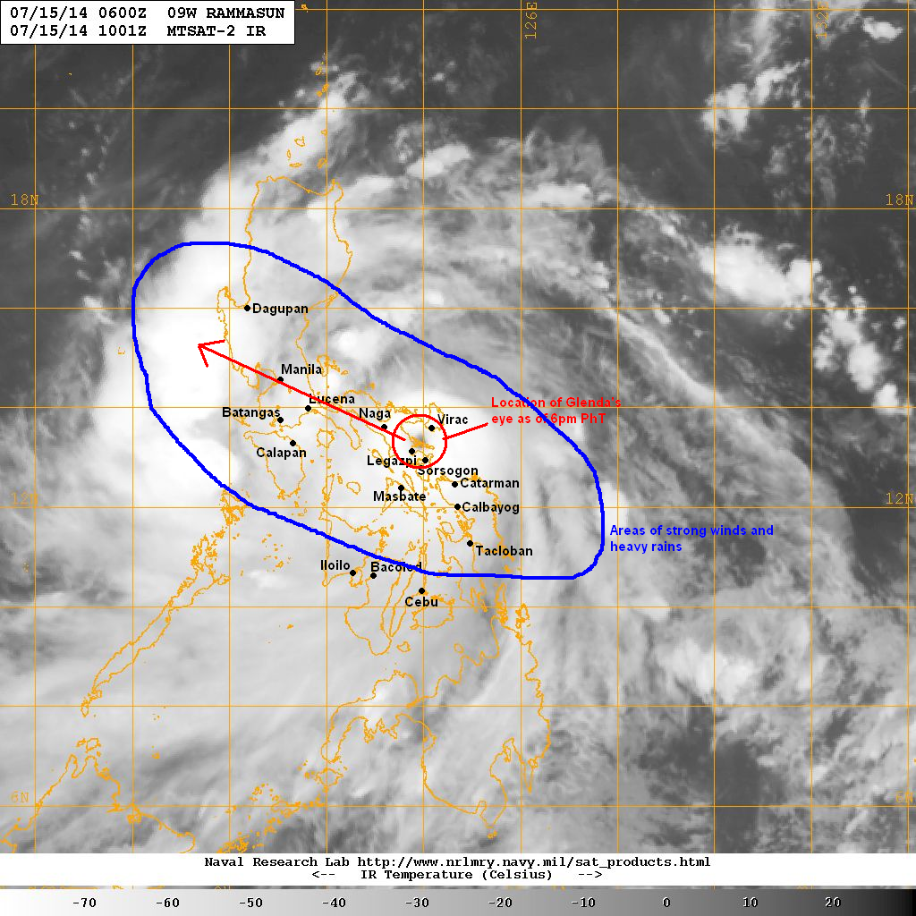
Rammasun (Bagyong Glenda) has rapidly intensified overnight and is now a Category 1 Typhoon. The system was last located approximately 120km east northeast of Catarman, Northern Samar, 180km southeast of Virac, Catanduanes, or about 220km east southeast of Legazpi, Albay. Maximum sustained winds are at 150kph with gusts of up to 185kph. Typhoon Rammasun is currently moving westward at 20kph.
VIS Image from NRLMRY
Latest satellite image shows the center of Rammasun moving very near the island of Samar. The central dense overcast remains strong and symmetrical with the center surrounded by strong convective activity. Much of Bicol and Eastern Visayas are already experiencing heavy rains and strong winds. Weather conditions will only get worse throughout the day today.
Forecast Track (NOT OFFICIAL!)
Typhoon Rammasun (Glenda) is forecast to make landfall in the Albay/Sorsogon area later this evening. The system will then move across the Bicol Region and eventually into Southern Luzon. Metro Manila will experience strong winds and very heavy rain tonight and into tomorrow. Even parts of Northern Luzon could see heavy rains by Wednesday.
Rammasun is forecast to exit Luzon into the South China Sea (West Philippine Sea) by Thursday morning and will head towards Southern China by late this week. Heavy rains will continue across Luzon by Thursday but the weather should slowly improve later that day.