______________________________
Please LIKE our Facebook Page for the latest updates!
If you have any videos or images showing the impacts of Typhoon Glenda, please share them with us on our Facebook Page or email us at philippineweather@yahoo.com
Please watch our latest Video Update this afternoon for the complete analysis and in-depth forecasts for the areas that will be impacted by Typhoon Glenda.
Typhoon Rammasun (Bagyong Glenda) has intensified even further as it makes landfall in Albay Province. The system was last located approximately 10km northeast of Legazpi City, Albay, 40km northwest of Sorsogon City, Sorsogon, 60km southwest of Virac, Catanduanes, or about 80km southeast of Naga City, Camarines Sur. Maximum sustained winds are at 185kph with gusts of up to 230kph making Rammasun a Category 3 Typhoon!
As of 5pm this afternoon, here are the latest PAGASA Public Storm Signal Warnings:
Signal #3: Catanduanes, Albay, Sorsogon, Marinduque, Camarines Norte, Camarines Sur, Masbate, Quezon, Polilio Island, Laguna, Batangas, Rizal, Northern Samar, Norther portions of Samar and Eastern Samar.
Signal #2: Southern Aurora, Cavite, Bulacan, Pampanga, Bataan, Nueva Ecija, Pangasinan, Tarlac, Zambales, Lubang Island, Oriental Mindoro, Romblon, Biliran, Rest of Eastern Samar, Northern Leyte, Metro Manila.
Signal #1: Northern Aurora, Quirino, Nueva Vizcaya, Benguet, La Union, Occidental Mindoro, rest of Leyte, Southern Leyte, Northern Cebu including Cebu City. Camotes Islands.
IR Image from NRLMRY
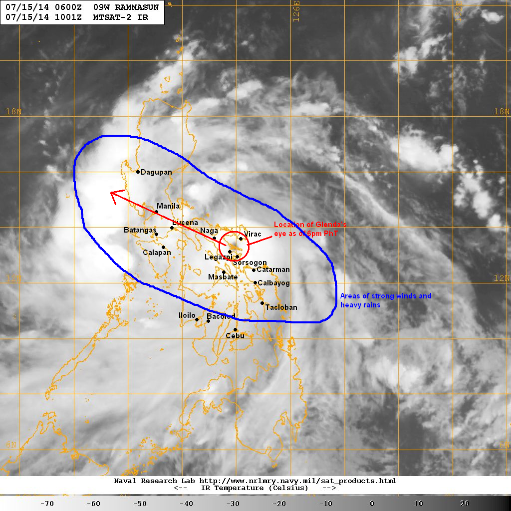
Latest satellite image shows the eye of Rammasun (Glenda) making landfall in Albay. The system rapidly intensified with a clear 20-km diameter eye forming surrounded by a very symmetrical Central Dense Overcast. Legazpi City reported a pressure drop to 974mb along with winds of up to 100kph. We're expecting the city to get raked in the next few hours which will definitely bring significant wind damage and even storm surge along the coast.
Forecast Track (NOT OFFICIAL!)

Typhoon Rammasun will continue moving west northwestward moving across the provinces in the Bicol Region tonight. Heavy rains will continue across Southern Luzon and parts of Visayas along with strong winds. Stormy conditions will soon move into parts of CALABARZON including Metro Manila in the morning hours tomorrow (Wednesday) with the worst conditions likely to occur in Manila around noontime.
By Wednesday evening, we're forecasting Glenda to move into Central Luzon and eventually exit into the South China Sea (West Philippine Sea). However, rains will not end across Luzon until Thursday morning. We're expecting a total of up to 300mm of rain in some areas in Luzon.
We'll have another update in the morning. Stay safe!
No comments:
Post a Comment