Issued (2230 UTC) 630am PhT 122516
________________________________
Like our FACEBOOK PAGE for the latest updates on this storm!
Super Typhoon Nock-ten (Bagyong Nina) is now bearing down towards the Philippine Islands on this Christmas Day. The eye of Nock-ten was last located approximately 200km east of Virac, Catanduanes or about 560km east southeast of Manila. Maximum sustained winds are at 240kph with gusts of up to 295kph. STY Nock-ten is currently moving westward at 15kph.
*****
As of 5am this morning, PAGASA has raised Public Storm Warning Signal #3 for Catanduanes, Albay, and Camarines Sur.
Signal #2 for Southern Quezon, Marinduque, Camarines Norte, Masbate, Ticao Island, Burias Island, Sorsogon, and Northern Samar.
Signal #1 for Metro Manila, Batangas, Nueva Ecija, Southern Nueva Vizcaya, Southern Quirino, Zambales, Pampanga, Tarlac, Bulacan, Cavite, Laguna, Batangas, Rizal, rest of Quezon, Polilio Island, Aurora, Romblon, Occidental Mindoro, Oriental Mindoro, Lubang Island, Aklan, Capiz, Samar, Eastern Samar, Biliran, Leyte, and Bantayan Island.
*****
IR Image from NRLMRY
Latest satellite image shows the pinhole eye of Super Typhoon Nock-ten surrounded by deep convective activity. The storm underwent a period of rapid intensification over the past 48 hours as it moved across the Philippine Sea. It will likely maintain this intensity as it makes landfall in Bicol later today.
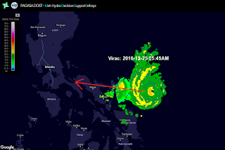
Radar Image from PAGASA
Latest radar image from Virac, Catanduanes shows the eye of Nock-ten (Bagyong Nina) along with its rain bands approaching the Bicol Region and parts of Samar. Rain will continue to spread inland, along with gusty winds. Conditions will only worsen as the day goes by.
COAMPS Rainfall 72-hr Accumulation Output (NOT OFFICIAL)
The image above is one of the many computer model depictions with 3-day rainfall accumulations. We're expecting heavy rains to be observed across much of Bicol and Southern Luzon, as well as parts of Visayas. Some areas (highlighted above) could see as much as 300mm of rainfall over the next few days.
Forecast Track from Japan Meteorological Agency (JMA)
Super Typhoon Nock-ten will make landfall in the island of Catanduanes later this afternoon. Winds of up to 260kph are possible, especially near the core of the typhoon. Winds will weaken further inland but will still be capable of causing destruction to properties. Nock-ten is, then, forecast to continue moving generally westward into Southern Luzon, passing just south of Manila by early tomorrow morning (Monday). By this time, we expect Nock-ten to weaken to lower-category typhoon but will still pose a significant threat for the metropolitan region.
Nock-ten will emerge into the South China Sea (West Philippine Sea), as a much weakened cyclone, by late Monday evening. Stormy conditions will likely persist across the western seaboard of Luzon during this time. Improving weather is expected by Tuesday morning across the entire area.
The image above is taken from the Japan Meteorological Agency. The track is in pretty good agreement with other weather agencies in the region (i.e. PAGASA, JTWC).


No comments:
Post a Comment