Issued (1230 UTC) 830am PhT 080913
_______________________________
Tropical Depression 11W (Bagyong Labuyo) continues to slowly consolidate as it moves across the Philippine Sea. The system was last located approximately 920km east of Virac, Catanduanes. Maximum sustained winds are at 55kph with gusts of up to 75kph. TD 11W is moving west northwestward at 20kph.
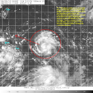
IR Image from NRLMRY
Latest satellite image shows the cyclonic circulation of 11W continues to improve with convective banding forming and wrapping around the center. Outflow, especially poleward outflow, is excellent as well. Satellite analysis suggest that the system may become a Tropical Storm later tonight.
Forecast Track (NOT OFFICIAL!)
Tropical Depression 11W is forecast to continue moving west northwestward over the next two days. Favorable conditions are forecast to persist along the path of the cyclone which could allow it to rapidly intensify to a typhoon by as early as Sunday. Latest computer models show a track towards Northern Luzon and the timing could put the landfall by Sunday night or early Monday morning. TD 11W will then emerge into the West Philippine Sea/South China Sea and could continue towards Southern China by early next week.
We'll have another update tomorrow morning.


No comments:
Post a Comment