Tropical Storm Haikui continues to slowly intensify as it moves across the Japanese Islands. It was last located approximately 100km north of Okinawa (between Okinawa and Tokunoshima Island). Maximum sustained winds are now at 100kph with gusts of up to 130kph. Haikui is currently moving west northwestward at 15kph.
Stormy conditions persist across the region and several warnings remain in effect from JMA including Storm, Flood, Heavy Rains, and High Waves. Kadena Weather has also raised TCCOR 1 in response to the effects of Haikui. Continue to monitor developments in your area on the news, JMA, or Kadena.
Radar from JMA

Latest radar from Okinawa shows the center of Haikui is becoming better established. Furthermore, bands of light to moderate rains continue to move across Okinawa, Amami, and the nearby islands. Rains will continue through tonight with one more round of widespread moderate to heavy rains possible in 3 hours. Accompanying those rains will gusty winds of up to 100kph. Some stations reporting sustained winds of 50 to 70kph and rainfall totals of 40 to 80mm so far. Stormy weather will continue into tomorrow but should start to die down tomorrow evening. However, as Haikui slows down over the Eastern China Sea, there will still be gusty winds and occasional rain showers. For more radar images, forecasts, and warnings from Japan Meteorological Agency, please click HERE
IR Image from NRLMRY
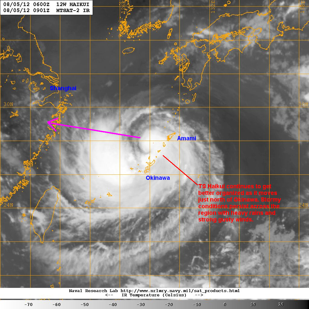
Satellite presentation of Haikui has really improved compared to yesterday. The core is better established and strong convection continue to fire near the center. Dry air, however, continues to wrap from the east and the north but it is obvious that Haikui is successfully fighting that dry air. Outflow remains good, wind shear remains light, and sea surface temperatures remain favorable.
Forecast Track (NOT OFFICIAL!)

Tropical Storm Haiku is forecast to continue moving slowly across the Eastern China Sea, intensifying along the way. Depending on the rate of intensification, it could reach typhoon status as early as tomorrow evening (Monday). Current forecast tracks from agencies and computer models continue to bring Haikui towards Eastern China by Wednesday. Though there are still some computer models that insist on an abrupt turn to the northeast, the majority of models do agree on a track towards China.
It will slow down even more across the Eastern China Sea and could make landfall along the coast of Zhejiang Province, 250km south of Shanghai, as early as Wednesday morning. While intensity forecasts are keeping Haikui as a minimal typhoon, there is a very small chance it could undergo Rapid Intensification by Tuesday, which reflected on our forecast above (bringing Haikui to a Category 2 typhoon). It will rapidly weaken, though, as it moves across China becoming a Tropical Depression by Thursday as it moves west of Shanghai.
If you have any storm reports, questions, or comments, please email us at philippineweather@yahoo.com
We'll have another update tomorrow. Stay safe!
__________________________________________
Issued (0930 UTC) 530pm PhT 080512
No comments:
Post a Comment