We begin February with mostly benign weather conditions except maybe in Eastern Asia where a frontal system is moving through Northern Japan. Ahead of it, the warm front is bringing mild air with temperatures climbing into the teens across Kanto Plain (Tokyo Area). As this front moves through, cold arctic air will return to the region bringing very cold temperatures into Saturday. A piece of that cold air will also affect the Philippines, as we'll discuss later on.
IR Image from NRLMRY
The extra-tropical low moving through Japan will bring mostly rain across the southeastern part of Honshu, generally around the Tokyo area. The western side of the island will have snow that could pile up to another 50cm, especially in higher elevations. The continuous northwesterly winds off the Sea of Japan will continue creating snow showers for the next few days. Rest of Eastern Asia should be dry although as I said, temperatures will drop tremendously. Seoul could get down into the -15 to -20C by Friday night while Beijing could be in the -10 to -15C in that same time frame; Tokyo on the other hand could get down to -2C and only climb into the positive single digits by Friday and Saturday.
Another front, albeit weaker, is moving through the Western Pacific, setting up a weak shear line across the Marianas and is enhancing some thunderstorms in the vicinity. The tail-end located in the Philippines is also bringing light to moderate rain showers, particularly in the Bicol Region. Some places here have already received more than 100mm in the past 24 hours. More showers in the forecast, unfortunately. Rest of the Tropics is quiet with some showers observed in and around the South China Sea, although not expecting widespread precipitation here.
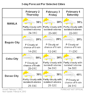
PHILIPPINES 3-DAY FORECAST
Forecast Graphic, NOT OFFICIAL!
Luzon
Mainly clear here, except for Central Luzon as well as the Bicol Region. Showers continue to linger due to the influence of the cold front; expect another 50 to 100mm by tomorrow around Catanduanes, Albay, and Naga. Also some light showers for Quezon, Rizal, and Aurora. Chances for thunderstorms will continue for the rest of Luzon. As for temperatures, we are forecasting a slight cooldown beginning Friday and could last into Saturday. Computer models have been hinting about this for days now and the solution seems to hold so have brought temps down by this weekend. Baguio City could see temps in the low teens (around 11C). Laoag and other areas in Northern Luzon could also see morning temps around mid to upper teens (around 17C) by Friday and Saturday. Manila will also experience a cooler morning but not as significant as the north.
Visayas
The shear line affecting Bicol is forecast to sag southward as the front pulls away so we have increased chances for rain for tomorrow, especially around Cebu. Mainly light rains of around 30 to 50mm so not very significant. Rain could linger into the weekend although it'll become more spotty and isolated by that time. Next chances of rain is by late Saturday as another frontal system moves across Northern Asia. Temperatures will run around normal. Not expecting the region to be affected by the cooling in Luzon although morning temps could still go around the low 20s, especially in more rural areas.
Mindanao
Clear weather expected here as well with only small chances for a stray thunderstorm or light rain showers. The rain line from Luzon is expected to reach Mindanao by Friday although by that time, it won't be as widespread so decided to retain 30% for Davao. Chances will increase by Saturday as a batch of light rain showers arrive from the east. Temperatures here will be warm with daytime highs reaching the mid 30s (around 33C) for tomorrow with only a slight cool down by this weekend.
Next update will be on February 4, Saturday.
_______________________________________
Issued (08 UTC) 4pm PhT 020112


No comments:
Post a Comment