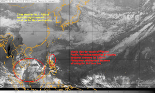
Mostly clear weather dominates much of our forecast area. There are widespread showers across South China Sea and the Philippines but most of the precipitation aren't too heavy and will not be much of a problem. Siberian High remains in place for East Asia bringing clear but cold conditions, except for Western Honshu--where snow continues to pile up.
IR Image from NRLMRY
Latest satellite image shows scattered to widespread rain showers are affecting parts of Indochina, mainly Cambodia and Vietnam, as well as Malay Peninsula. There are also some reports of rain across Northern Borneo with amounts reaching up to 50mm. Showers will continue for these areas although amounts should be insignificant. Rain showers should decrease in coverage by tomorrow. Easterlies, meanwhile, is enhancing some rain showers across Eastern Philippines, particularly in Central Luzon as well as in Northeastern Mindanao. Places like Baler in the north have reported around 50 to 60mm of rain; Hinatuan in Mindanao is reporting around 50mm. We'll discuss more about the Philippines below. Meanwhile, cold temperatures remain across much of Eastern Asia. There are some scattered rain/snow showers for places in Central China, near the Yangtze River. Snow for Western Honshu as well with as much as 1 meter of snow for the higher elevations. Temperatures for this region will remain cold and will even be colder by the middle part of this week!
PHILIPPINES 3-DAY FORECAST
Forecast Graphic, NOT OFFICIAL!
Luzon
Mainly clear for Luzon with the exception of eastern and southeastern parts. Latest satellite image shows showers continue to linger for Eastern Luzon, basically east of the Sierra Madre. It could be because of downsloping winds converging with the weak easterlies which in turn creates instability and lift. Models are showing this rain clouds to continue affecting the area for the next 2 days. With that, decided to bring 40% to Manila and Baguio for tomorrow. Rainfall amounts will be light, most of which should be confined to eastern locations such as Aurora, Bicol Region.
Visayas
Mostly clear here as well with some scattered thunderstorms being spotted on satellite. Mainly dry for the next 3 days although models showing some scattered showers for tomorrow so have put 50% chance for Cebu. Next chance of precipitation comes on Wednesday. Temperatures will remain average; between 24 to around 31C.
Mindanao
Expecting drier weather for Mindanao although rain showers could linger until tomorrow. Slight chances for thunderstorms will remain thereafter. No significant weather make in sight. Temperatures will be warm across the region with temps spiking into the low to mid 30s during the afternoon hours.
Next update will be on February 1 (Wednesday).
_______________________________________
Issued (0830 UTC) 430pm PhT 012912


No comments:
Post a Comment