IR Image from NRLMRY
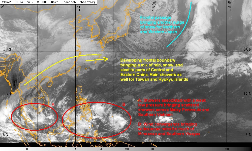
First we'll look into the rains in Indochina. We have the convergence associated with the monsoon producing scattered rain showers for parts of Malay Peninsula and Borneo Island; stray showers also possible for Southern Vietnam. Aside from the monsoon, there is a weak low pressure area approximately 500km south of Ho Chi Minh City. We are not expecting any development for this LPA although it will continue to bring rains to Indochina for the next 2 days. Recent rainfall reports are generally less than 100mm. We expect these same rain amounts to continue before precipitation begins to die off.
A surge of convection associated with the convergence is also affecting Southern Philippines. Parts of Eastern and Central Mindanao have received around 50 to 80mm of rain so far. Some parts of Visayas also getting light to moderate rain showers this past 36 hours. While rainfall amounts will be light to moderate, still expect some minor flooding and even landslides in mountainous areas. We'll discuss more about this precipitation later in our post.
Moving north, we are seeing some widespread light to moderate rains across Central and Eastern China. There have also been reports of sleet and snow in the higher eleveations. Mainly rain, though for parts of Southeastern China including the provinces of Guangdong and Fujian. This batch of precip is associated with a developing frontal boundary located in Eastern China. Moist and unstable atmosphere is triggering showers that extend as far south as Northern Vietnam and Thailand; Ryukyu Islands and Northern Taiwan will also continue seeing some light rains for the next 2 days. Computer models are handling this energy very well and is being shown to begin tracking eastward into the Pacific Ocean. Once developed, the cold front could affect Northern Philippines by as early tomorrow.
Meanwhile, we continue to see snow for parts of Western and Northern Japan. Snow depth in some locations already exceed 3 meters! As much as 1 meter more of snow is expected especially in the higher elevations. Korean Peninsula and NE China remains fairly dry. Temperatures remain cold throughout although we expect a slight moderation by the middle of next week. Just want to note as well that the overall pattern of the atmosphere is somewhat changing this week, influencing the track of extra-tropical lows in E Asia. If computer models are right, we expect storms to track south of Japan this week.
PHILIPPINES 3-DAY FORECAST
Forecast graphic, NOT OFFICIAL!

Mainly dry conditions with moderate to strong northeasterly winds. Showers from the south are not expected to affect Luzon until tomorrow afternoon so left a 30% for rain for both Manila and Baguio. A higher chance of precipitation by Monday as the front in E China moves on by. Not expecting too much although increased chances to 40% in Manila and 50% in Baguio. Threat of rain continues throughout the week. Palawan will have higher chances of rain as well as the Bicol Region. Temperatures around 24-31C, with a slight cool down by Monday as rain and cloud cover arrives.
Visayas
Rain will overspread the region tonight and will continue into tomorrow. Eastern Visayas will continue to see rain until Monday at least; amounts will be around 100mm. Keeping temperatures on the cool side due to the precipitation.
Mindanao
Mainly wet with on and off showers and isolated thunderstorms. Higher chance of rain on the eastern parts. Zamboanga Peninsula also seeing some scattered rainshowers. These disturbances will continue for the next 24 to 36 hours. Another batch of rain around Palau is expected to affect the region by tomorrow. Computer models are showing a decrease in rain coverage by Monday so decided to decrease chances to 40% in Davao. Threat for isolated showers remain throughout.
Another update by January 17, Tuesday.
_______________________________________
Issued (0930 UTC) 530pm PhT 011411
No comments:
Post a Comment