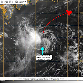
Tropical Depression 13Wcontinues to move north well south of Japan. It was last located approximately 940km south southwest of Tokyo. Maximum sustained winds remain at 55kph gusting to 80kph. TD 13W is moving north northeastward at 15kph.
VIS Image from NRLMRY
Visible Satellite image (above) shows an exposed low-level circulation center. The higher cloud tops that indicate convection is displaced to the northwest because of moderate wind shear of around 20kts around TD 13W. The shear has really hampered its chances of developing into a tropical storm.
Forecasts continue to bring TD 13W to the northeast, away from Honshu. It should remain a tropical depression before weakening and dissipating by this weekend.
Meanwhile, the SW Monsoon in the Philippines has weakened now mainly affecting some parts of Visayas and Mindanao, including Palawan. Isolated thunderstorms, on the other hand, will continue to occur throughout parts of the Philippines as that daytime heating creates instability in the atmosphere.
Aside from TD 13W, no other disturbance exists in the Pacific.
______________________________________
Issued (0730 UTC) 330pm PhT

No comments:
Post a Comment