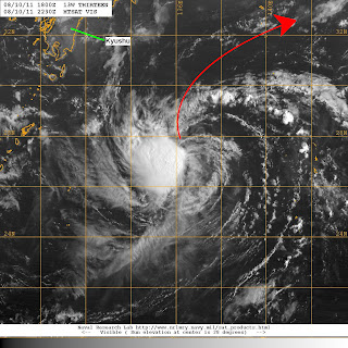
Tropical Depression 13W remains weak as it moves across the Philippine Sea. It was last located approximately 880km east northeast of Okinawa. Maximum sustained winds are still at 55kph gusting to 80kph. TD 13W is moving north northwestward at 20kph.
Latest VIS and IR images continue to depict blowing convection that is displaced north and northwest of the center. There still appears to be moderate wind shear of around 20kts that is hampering the development of 13W. As we have said before in our previous update, we don't really expect 13W to intensify that much. There is still a chance of it becoming a tropical storm within the next 24 to 36 hours if shear relaxes just a bit. Forecast track takes 13W northeastward well south of Japan.
VIS Satellite image from NRLMRY
_______________________________________
Issued (2330 UTC) 730am PhT 081111

No comments:
Post a Comment