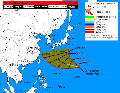
Tropical Storm Ma-On continues to quickly intensify as it moves northeast of the Northern Mariana Islands. TS Ma-On was last located approximately 980km northeast of Guam. Maximum sustained winds remain at 95kph, gusting to 120kph. The storm is moving west northwestward at 20kph.
As of 4pm today (Philippine Time), the National Weather Service (NWS) in Guam has issued a Tropical Storm Watch for Pagan, Alamagan, and Agrihan Islands in the CNMI. Expect tropical storm force winds of as high as 40mph (~65kph) which could begin to affect the region as early as tonight. Always tune in to the NWS for latest weather warnings and updates.
Moving on, latest visual and infrared imagery shows that the storm has begun to re-intensify. Note that the storm has weakened a little bit midday today although has since improved again. A rugged eye feature is beginning to form again. Latest SSMI 37GHz image also shows an improved activity in the lower levels of the storm and the corresponding 85GHz image also showing a ring now forming in the upper levels of TS Ma-On. It remains to be seen, though, whether this trend will continue for the next few hours because if it is then Rapid Intensification might already be happening. Latest Water Vapor imagery also showing the TUTT northwest of the system moving away allowing TS Ma-On to continue developing its Poleward Outflow Channel which was hindered by the TUTT for the past 24-36 hours. Having both Poleward and Equatorward Outflow will help Ma-On with its Rapid Intensification process.
Forecasts up to 3 days out remain clustered with computer models in good agreement showing a west northwesterly track passing well north of Guam tomorrow and south of Iwo To (Iwo Jima) later tomorrow into evening. 3 days and beyond, however, models begin to diverge as they continue to latch onto a solution of a poleward track towards Japan. Right now, GFS seems to be the eastern outlier while the UKMET is the western outlier. ECMWF is slightly west of the consensus, forecasting a Kyushu landfall early next week. Models are also expecting a rapid intensification with the EURO and GFS being the most aggressive. By the looks of things, it does look like we could be dealing with a major typhoon in 3 to 4 days' time and Japan looks to be in the crosshairs as of the moment.
This storm is not expect to affect the Philippine directly although it will certainly induce that SW Monsoon again which is currently weak. TS Ma-On could enter the Philippine Area of Responsibility Saturday morning although it will quickly exit the territory, as early as Saturday night. If it does enter, PAGASA will give the name "Hannah".
Our forecasts are in good agreement with JTWC and JMA and remains west of the consensus from GFS, CMC, and Nogaps. Our forecast only goes out to 5 days (Sunday) although right now, we are forecast a landfall either in Kyushu or Shikoku with the intensity being a major typhoon (Cat 3) or higher.

Video Update
Next text update will hopefully be around 12am midnight, Philippine Time.
__________________________________
Issued (0830 UTC) 430pm PhT 071311
No comments:
Post a Comment