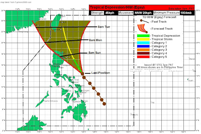
As of 11am today, Signal Warning #1 is in effect for Catanduanes, Sorsogon, Albay, Camarines Sur, Camarines Norte, Polilio Island, Aurora, Cagayan, Isabela, and Northern Samar.
Latest rain reports in the region indicate moderate rainfall with amounts ranging from 30-80mm this past 24 hours. Since the bulk of convection is being sheared to the west, it means light to moderate rain will continue to the areas under the warning.
As for the forecast, computer models are predicting a general northwestward movement before making a landfall in extreme northern Cagayan. TD 06W will then track across the Luzon Strait on Monday. This scenario is supported by JTWC and PAGASA.
I, however, am leaning on the eastern envelope of the forecast. Our track basically puts TD 06W just east of Luzon. It could make landfall in Cagayan on Sunday night before heading off towards Taiwan. A number of computer models also support this scenario. The intensity will be limited to a weak tropical storm due to unfavorable conditions that exist north of Luzon.

As always, it could be that our forecast will turn out wrong and so it is best to be updated with the latest warnings and forecasts not only from this site but also from official weather bureau such as PAGASA.
___________________________________
Issued (07 UTC) 3pm PhT 061811
No comments:
Post a Comment