________________________________
Super Typhoon Neoguri (Bagyong Florita) has maintained its intensity as it continues to move towards the Japanese Islands. The eye was last located approximately 300km southeast of Miyako Island, 460km south southwest of Okinawa, or about 620km southeast of Taipei. Maximum sustained winds are at 250kph with gusts of up to 305kph. STY Neoguri is moving north northwestward at 25kph.
The Japan Meteorological Agency has issued several Warnings and Watches for the Ryukyu Islands including an Emergency Weather Warning for Miyakojima. Dangerous conditions are forecast to occur within the next 24 hours in this region. Please follow the forecasts and warnings of your local officials!
IR Image from NRLRMY

Latest satellite image shows that the eye remains well-defined and is still looking symmetrical this evening. However, cloud tops continue to warm which may mean that the system has reached its peak and may start to weaken overnight. Nevertheless, do NOT underestimate this system as it will still pack intense winds as it moves near the islands by tomorrow morning.
Radar Image from JMA
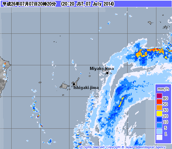
Latest radar image shows outer rain bands from Neoguri are starting to fall across the Miyako Islands. A band of heavy rains is also approaching Okinawa and will start to impact that island later this evening. The heavier rains will continue to approach from the south and should start to overspread the region beginning early tomorrow morning. Rain won't end until late Tuesday evening and we are expecting up to 400mm of rain in some areas! For the latest radar images and forecasts for Japan, please click HERE (JMA Website)
Forecast Track (NOT OFFICIAL!)

Super Typhoon Neoguri will continue moving north northwestward and will move very near Miyako-jima by early tomorrow morning (Tuesday). Despite the weakening observed on satellite, we don't think Neoguri will lose that much strength. It will still be packing winds of more than 200kph (with Miyako-jima being the most vulnerable) as it moves near the islands by tomorrow. The eye will pass roughly 160km west of Okinawa by 3pm tomorrow afternoon (Tuesday, Japan Time). The worst conditions won't end until early Tuesday evening.
By early Thursday morning, Neoguri is forecast to make landfall in the island of Kyushu as a weakening Category 3 Typhoon. It will bring strong winds and heavy rains across Mainland Japan through the weekend. Even parts of South Korea may feel the effects of this typhoon.
This is our Video Update that we posted this morning. Please watch for the forecasts for Okinawa and the rest of Japan. We'll have another update Video Update tomorrow morning.
Stay safe!
No comments:
Post a Comment