Issued (1330 UTC) 930pm PhT 110713
_________________________________
Haiyan (Bagyong Yolanda) has intensified even further to the upper reaches of Category 5 Super Typhoon intensity! The eye of Yolanda was last located approximately 270km southeast of Guiuan, Samar; 280km east northeast of Surigao City; or about 350km southeast of Tacloban City. Maximum sustained winds are now at 305kph with gusts of up to 370kph! Super Typhoon Haiyan/Yolanda is moving west northwestward at 35kph.
As of 5pm this afternoon, PAGASA has issued the following Public Storm Warning Signals:
Signal #4: Eastern
Samar, Samar, Leyte, Southern Leyte Biliran Province, extreme Northern
Cebu including Bantayan Island, Capiz, Aklan, Northern Antique.
Signal #3: Masbate, Ticao Island, Sorsogon, Romblon and Calamian Group of Islands, Rest
of Antique, Iloilo, Guimaras, Northern Negros Occidental, Northern
Negros Oriental, Northern Cebu including Cebu City, NRN Samar, and Bohol, Siargao Island and Dinagat Province.
Signal #2: Mindoro Provinces, Marinduque, Albay, Extreme Northern Palawan and Burias Is., Rest of Negros Occidental, Rest of Negros Oriental, Siquijor and Rest of Cebu, Camiguin, Surigao Del Norte, Surigao Del Sur and Agusan del Norte.
Signal #1: Camiguin, Surigao Del Norte, Surigao Del Sur and Agusan del Norte, Misamis Oriental and Agusan del Sur.
Areas under Signal #4 (winds of more than 185kph) will experience total devastation with many structures likely sustaining damage. Even concrete buildings will see some damages. Signal #3 (101 to 185kph) will have damaging winds as well and many structures could still see some damages. Signal #2 (61 to 100kph) should also expect strong winds that can topple small trees and blow some roofs. Wooden houses may still survive but residents are not recommended to stay in them. Signal #1 (up to 60kph) will have some strong winds but are not expected to bring widespread damages.
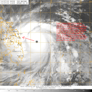
IR Image from FNMOC
Latest satellite image shows a very menacing storm with a perfectly-defined eye surrounded by very strong convective activity. This is personally the strongest storm I've witnessed and could even rival Super Typhoon Megi (Juan) of 2010. Radial outflow is very good and the storm is just a classic textbook example of how a typhoon should look like.
Radar Image from ClimateX PH
Unfortunately, we will see some widespread damages across much of Visayas. Rains are already impacting some islands there especially in Cebu, Bohol, Samar, and Leyte. The radar image above shows bands of light to moderate rains and some areas in red which signify heavy rains. There could be as much as 300mm of rainfall accumulating in the next 24 to 48 hours in the provinces I just mentioned.
For more radar images and rainfall forecasts, click HERE (ClimateX PH)
Another threat that we haven't really touched upon is the storm surge. We could see anywhere from 6 to 10 feet of water inundating many coastal locations. The very threatened city of Tacloban is just 15 feet above sea level and will surely be feeling the effects of the storm surge. Other coastal locations along the path of Yolanda will also see significant storm surge so if you live near the sea please move away now and go to the nearest evacuation centers if you are in Visayas!
Again, this is a very powerful and dangerous typhoon that will make landfall in less than 12 hours! Please, please follow the directions of your local officials. We are not an official agency so do not use our posts for life or death decisions. Stay safe! We'll have another update tomorrow morning.


No comments:
Post a Comment