Issued (0430 UTC) 1230pm PhT 101913
__________________________________
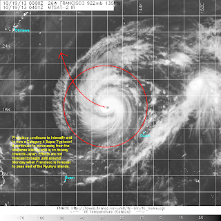
Just as we had predicted, Francisco has intensified a little bit more and is now a Category 4 Super Typhoon! The eye of Francisco was last located approximately 600km northwest of Guam or about 1,670km southeast of Okinawa. Maximum sustained winds are now at 250kph with gusts of up to 305kph. Francisco is currently moving west northwestward at 15kph.
IR Image from FNMOC
Latest satellite image shows that Francisco continues to have a very organized structure with a well-defined eye surrounded by strong convective activity and good outflow. However, over the past 3 hours, we've noticed a little impinging and weakening on the southern periphery of the storm. Microwave image also suggest that the southern half of the eyewall is somewhat being impinged. We are not sure yet if Francisco is starting to undergo an eyewall replacement cycle although that could definitely happen anytime soon.
Forecast Track (NOT OFFICIAL!)
With that said, we think the system will maintain its present Category 4 intensity; it may slightly weaken over the next 24 hours but should re-intensify a little bit by Monday. Waters around the Philippine Sea are still very warm and we expect wind shear and moisture environment to be favorable for further intensification. There may even still be a chance of Francisco achieving Category 5 status.
We haven't changed our Forecast Track significantly. Francisco is currently tracking a little farther south than we expected but overall, it should still recurve toward Japan by early next week. It may get close to the Ryukyu Islands to bring scattered rains and gusty winds but the strongest impacts should be felt across Kyushu, Shikoku, and Honshu. Stormy conditions should be felt across Mainland Japan beginning Tuesday.
We'll have another update later tonight.


No comments:
Post a Comment