Issued (11 UTC) 7pm PhT 071213
___________________________
Video Update:
Typhoon Soulik is now moving just south of the Japanese Islands and is currently heading towards Taiwan. The center was last located approximately 60km south southeast of Ishigaki (pop. 50,000) or about 280km east southeast of Taipei, Taiwan. Maximum sustained winds are down to 165kph with gusts of up to 205kph. Soulik is moving west northwestward at 20kph.
As of 5pm this afternoon, PAGASA has raised Public Storm Warning Signal #2 for Batanes Group of Islands and Signal #1 for Babuyan and Calayan Groups of Islands. Meanwhile, JMA has issued Storm Warning along with Heavy Rain and High Waves Warnings for Ishigakijima and Yonagunijima. Finally, Taiwan's CWB has issued Sea and Land Typhoon Warning along with Heavy Rain Warnings for the entire area.
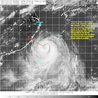
IR Image from NRLMRY
Latest satellite image shows Soulik moving just south of the Japanese Islands. Convective activity remains subpar although the system itself looks like it has improved somewhat since yesterday. The inner eyewall still hasn't eroded and it seems the system is having a hard time completing that eyewall replacement cycle. Due to the impending landfall, we no longer expect Soulik to re-intensify as it will probably never complete that ERC.
Radar Image from JMA
Latest radar image out of Yaeyema/Miyakojima showing the outer eyewall affecting the islands with the inner eyewall passing just to the south. These bands of rain could drop up to 20mm of rain per hour. Along with the rains, strong winds are also being reported now in the islands. A station reported sustained winds of about 130kph and another one reported a gust of about 165kph. Even Okinawa, which is farther north reported winds of up o 120kph earlier today. For the latest radar data, please click HERE (JMA Website)
Forecast Track (NOT OFFICIAL!)
Taiwan is forecast to begin feeling the effects of Soulik beginning tonight. Rains and winds will only get worse through the early morning hours as the system nears landfall. We expect Soulik to make landfall by around 5am local time tomorrow morning (Saturday) on the northern portion of Taiwan. It will then move near the city of Taipei bringing typhoon winds in the metropolitan area. Soulik will re-emerge into Taiwan Strait tomorrow night and should weaken to a Category 1 Typhoon before making its second and final landfall in the province of Fujian Province in Southeastern China.
We'll have another update tomorrow.


No comments:
Post a Comment