Issued (2230 UTC) 630am PhT 070113
_______________________________
Tropical Storm Rumbia (Bagyong Gorio) has finally left the Philippine Area of Responsibility and is on its way towards Southern China. The storm wast last located approximately 660km west of Laoag City or about 460km south of Hong Kong. Maximum sustained winds are at 85kph with gusts of up to 110kph. TS Rumbia is moving west northwestward at 30kph.
Due to the storm pulling away, PAGASA has dropped all Public Storm Warning Signals in the Philippines.
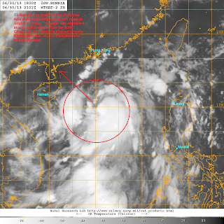
IR Image from NRLMRY
Latest satellite image shows strong convection wrapping tighter into the low-level center. Microwave image also suggest a weak formative banding trying to develop into an eyewall. Wind shear is starting to increase, however, and that is beginning to impinge on the northwestern periphery of TS Rumbia.
Tropical Storm Rumbia will continue moving northwestward today towards Guangdong Province in Southern China. Despite the increasing wind shear, we expect TS Rumbia to at least maintain its current intensity as it moves towards China. The storm is forecast to make landfall in Guangdong, near the Leizhou Peninsula, later tonight or perhaps early Tuesday morning. Rains will begin to impact the Chinese coast, including Hainan Island, later this afternoon becoming worse through the night. Rumbia will then rapidly weaken upon landfall and dissipating by Tuesday as a Tropical Depression.
We'll have another update later today.

No comments:
Post a Comment