________________________________
Much of the country is currently experiencing fine weather although some areas have been impacted by afternoon thunderstorms. One such occurrence happened in Metro Manila where a strong cell of thunderstorm moved through bringing quick-hitting heavy rains with pea-sized hail being reported in Quezon City as well. These thunderstorms are caused by the daytime heating during the afternoon hours. Some of these cells can get strong enough to produce hail but this is fairly common especially as we get into the Summer season.
IR Image from NRLMRY
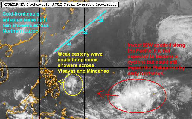
Speaking of the summer season, we are gradually transitioning into the warmer regime with the Northeast Monsoon (Amihan) getting weaker by the day. There is still a cold-front diving down that could bring scattered showers across Northern Luzon. We expect this to be the last major surge of the Amihan this month.
For other parts of the tropics, a weak easterly wave could bring some scattered showers across Visayas and Mindanao tonight and into tomorrow. Farther to the east, a Tropical Disturbance (Invest 99W) was spotted well south of Guam. This LPA is not forecast to become a cyclone as of this time. However, this disturbance will be moving westward and could eventually impact the Philippines by the early part of next week.
3-Day Weather Forecast (NOT OFFICIAL!)

Again, we expect some light rains to impact parts of Northern Luzon tomorrow. Parts of Central and Southern Luzon should see fairly clear skies with slight chances of thunderstorms (like what happened in Quezon City today) especially during the afternoon and early evening hours. Visayas and Mindanao, meanwhile, could see some rains tomorrow due to the Easterlies with much greater chance for precipitation by Sunday and Monday.
We'll have another update on Sunday, March 17.
No comments:
Post a Comment