*********************************
Text Update
Tropical Storm Bopha continues to intensify as it moves across the Pacific Ocean. The storm was last located approximately 530km southwest of Chuuk. Maximum sustained winds are now at 95kph with gusts of up to 120kph. TS Bopha is currently moving west southwest at 15kph.
IR Image from NRLMRY

Latest satellite image shows convective activity continues to improve with cold cloud tops around the cloud cover. Radial outflow is also getting better courtesy of the weak wind shear in the region. Further analysis, using microwave data (not shown here), suggest that an eye may be starting to form inside the storm. Curved banding is also present suggesting further development of Bopha. If the intensification trend continues, we are expecting the storm to attain typhoon status by tomorrow afternoon (Friday).
Forecast Track (NOT OFFICIAL!)
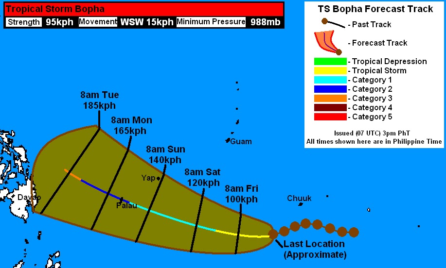
Computer models are starting to converge on a consensus regarding Bopha's track. Unfortunately, the current track looks pretty grim for Palau and the Philippines. Our latest forecast is now taking Bopha into the island of Palau by Sunday as a Category 2 Typhoon. Winds of up to 160kph and heavy rains are possible, please prepare now! Yap Island will be farther north and won't see typhoon conditions, although tropical storm winds of up to 65kph are still possible.
By next week, Bopha is forecast to turn more to the west northwest and could intensify into a Category 3 by Monday. There are still a lot of uncertainties but it does look increasingly likely that the Philippines may be impacted, in one way or another, by this system beginning Tuesday. Right now, anywhere from Mindanao all the way into Eastern Visayas should closely monitor the developments of Bopha. It is expected to enter the Philippine Area of Responsibility by Sunday so we expect PAGASA to begin issuing advisories by that time.
We'll have another update tomorrow. For those in Palau, again, please prepare now! For the latest warnings and forecasts for Micronesia, please head to the National Weather Service (Guam) by clicking HERE
_______________________________________________
Issued (1030 UTC) 630pm PhT 112912
No comments:
Post a Comment