Tropical Storm Gaemi has entered the Philippine Area of Responsibility last night and has been given the local name of "Bagyong Marce" by PAGASA. TS Gaemi/Marce was last located approximately 340km west northwest of Manila or about 250km west of the coast of Zambales. Maximum sustained winds are now up to 85kph with gusts of up to 110kph. Gaemi is currently moving southeastward at 10kph.
As of 5am this morning, PAGASA has not issued any Public Storm Warning Signals for the Philippines.
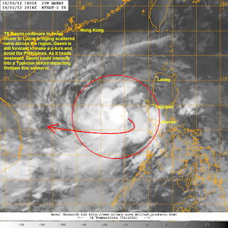
IR Image from NRLMRY
Latest infra-red satellite image shows the storm continuing to consolidate with a strong convective activity concentrated in and around the center. Radial outflow is still mediocre but it is improving. The proximity of Gaemi is starting to enhance more widespread rains across Central and Southern Luzon which could bring as much as 50mm of rain throughout today.
Tropical Storm Gaemi will continue moving southeastward, moving near enough to bring gusty winds and rains across parts of Luzon and Visayas. However, by tonight or early tomorrow Gaemi should make a u-turn heading to the west, avoiding making landfall in the Philippines. Computer models and forecast agencies are in good agreement with this scenario. As it moves westward across the South China Sea/West Philippine Sea, Gaemi will continue intensifying and could even become a Typhoon by Friday. Based on the current projections, Gaemi could make landfall in Vietnam this weekend.
We'll have another update on Gaemi later this afternoon along with our complete update for the other tropical cyclone--Tropical Storm Maliksi.
_____________________________________________
Issued (00 UTC) 8am PhT 100312

No comments:
Post a Comment