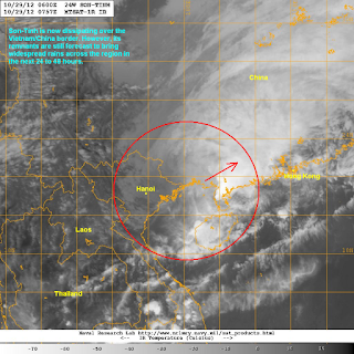
Tropical Depression Son-Tinh is now dissipating as it moves across Vietnam and crossing into China. The storm was last located approximately 180km northeast of Hanoi. Maximum sustained winds are now down to 45kph with gusts of up to 65kph. Son-Tinh is moving north northeastward at 10kph.
IR Image from NRLMRY
Son-Tinh made landfall as a Category 2 typhoon roughly 18 hours ago and has rapidly weakened to a Tropical Depression. Heavy rains and strong winds impacted Vietnam and has, unfortunately, already claimed three dead as per the latest reports. The strongest winds were confined near the coast as Hanoi only reported 40 to 80kph. However, widespread heavy rains did fall, sometimes amounting to as high as 300mm. Right now, Son-Tinh is dissipating as it moves across land and is no longer forecast to re-intensify.
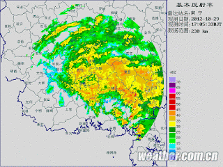
Radar from CMA
Even though the storm is dissipating, heavy rains continue to fall across Northern Vietnam and have actually spread into Southwestern China. As much as 100 to 200mm of rain is possible across the provinces of Guangxi and Guangdong Provinces over the next 24 to 48 hours. Hainan Island also reporting scattered showers. Some of these rain bands, may actually impact Hong Kong by Wednesday. For the latest radar images, forecasts, and warnings from China, please click HERE
Tropical Depression Son-Tinh will continue dissipating today but dangerous conditions will still persist across the region so please stay safe. Both the Joint Typhoon Warning Center and the Japan Meteorological Agency have given their final warnings for Son-Tinh. Likewise, this will be our final update for this Tropical Cyclone.
We'll have a Tropical Update tomorrow about the remnants of Son-Tinh and the weather across the rest of the Western Pacific.
_______________________________________________
Issued (09 UTC) 5pm PhT 102912


No comments:
Post a Comment