IR Image from NRLMRY
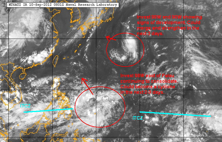
Invest 98W
We've been watching the area around Palau for almost a week now and the formation of Invest 98W seems to jive well with our predictions a few days ago of a possible cyclone development. This low-pressure area is still weak and very broad with disorganized convection. However, satellite analysis shows that a low-level circulation center is developing along with weak banding. Observations from Palau indicate gradual increase and winds and a slow drop in pressure since yesterday.
Due to the latest trends, JTWC has upgraded the system's chances to MEDIUM. JMA has actually upgraded this to a "minor" Tropical Depression. Computer models are also adamant in developing 98W in the next 2 days. As far as the track goes, the future cyclone would take a more northerly track and is not expected to make landfall in the Philippines. However, it will likely enhance southwest monsoon by the latter part of this week.
Invest 98W, along with the ITCZ, is enhancing showers across Visayas and Mindanao and could drop up to 50mm of rain tonight and into tomorrow.
Invest 99W and 90W
Two partially exposed low-level circulation centers have been spotted southeast of Japan. Invests 99W and 90W both have a clear circulation with 99W having better convective activity. Some models are showing weak development in this region although it is somewhat unclear whether the system will be of tropical in origin. Either way, we expect slow development as the two circulations will try to merge. JTWC has given 99W a MEDIUM chance of development and we'll be keeping an eye on this in the next few days.
We'll have another Tropical Update tomorrow.
___________________________________________
Issued (09 UTC) 5pm PhT 091012
No comments:
Post a Comment