**If you have any storm reports (images or videos) to share, email them to us at philippineweather@yahoo.com
**********************************
Text Update
Tropical Storm Ewiniar continues to move across the Pacific staying well away from Japan. It was last located approximately 510km southeast of Tokyo, Japan. Maximum sustained winds are slightly down to 95kph with gusts of up to 120kph. Ewiniar is currently moving east northeastward at 15kph.
IR Image from NRLMRY
Latest satellite image shows the center of the storm located well away from Honshu. Convection continues to fire up across the center but the coverage is small and the intensity weak. Much of the outer rain bands have also stayed well away from Japan although some light rain showers were reported in along the coast (Chiba Prefecture) last night but nothing too significant. Winds have also died down in the region, particularly in the Izu Islands, and we expect weather to gradually improve in the next 24 hours.
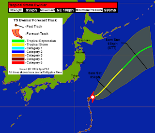
Forecast Track (NOT OFFICIAL!)
Latest Forecast Tracks for Ewiniar continue to bring it quickly to the northeast and isn't expected to impact Japan anymore. It will begin extra-tropical transition tonight and could complete the cycle by Sunday or Monday as the system moves harmlessly out to sea.
We'll have another update on Ewiniar tomorrow. We'll have our complete Text Update and Forecast Track for Typhoon Jelawat in about an hour.
_______________________________________________
Issued (09 UTC) 5pm PhT 092812


No comments:
Post a Comment