Jelawat (Bagyong Lawin) has slightly weakened overnight but it remains a very powerful Super Typhoon. The eye of the storm was last located approximately 340km east northeast of Aparri, Cagayan. Maximum sustained winds are down to 240kph with gusts of up to 295kph. Jelawat is currently moving northwestward at 15kph.
As of 5am this morning, PAGASA has issued Public Storm Warning Signal #2 for Batanes Group of Islands, Cagayan, Calayan, and Babuyan. Signal #1 is in effect for Ilocos Norte, Kalinga, Apayao, Abra, and Isabela.These provinces will continue to have strong winds and heavy rains throughout the day today. Winds of up to 100kph are possible in the islands north of Luzon especially in Batanes.
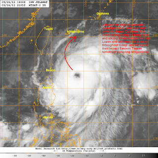
IR Image from NRLMRY
Latest satellite image shows the eye of Jelawat has grown last night after completing the eyewall replacement cycle. However, that eye is beginning to look rugged and less circular which may suggest weakening in the convective banding. We do have to stress that Jelawat will maintain this strong Category 4 intensity through tomorrow as outflow channels are still vigorous which should help offset the increasing wind shear and cooler waters near Taiwan.
There is very little change in the forecast tracks and we still expect Jelawat to continue its present northwesterly course, eventually turning more to the north by tomorrow (Friday). Strong winds and heavy rains will continue across Northern Luzon and the islands to the north today and into tomorrow; some areas could get as much as 200mm of rain. As Jelawat is forecast to turn northward, it is expected to avoid making landfall in Taiwan. However, eastern coast of the island should still expect winds of up to 60-80kph along with rains that could amount up to 150mm. By Friday evening, Jelawat could move near Ishigakijima and the nearby Yaeyema Islands of Japan. Jelawat will then turn northeastward and could move very near Okinawa by Saturday as a Category 2 or even a Category 3 typhoon.
We'll have more details in our forecasts later in our afternoon Text and Video Update. Continue to monitor the developments of Jelawat on the news and on the internet and also keep checking your official weather bureau as well as your local officials for the latest warnings and possible evacuation orders. Stay safe!
______________________________________________
Issued (23 UTC) 7am PhT 092712

No comments:
Post a Comment