As Tropical Storm Kirogi transitions into an extra-tropical system, the Western Pacific remains cyclone-free once again; however, that doesn't mean all is well across the region. Remnants of Haikui, the Southwest Monsoon, and a possible tropical cyclone formation highlight our Tropical Update for today.
IR Image from NOAA
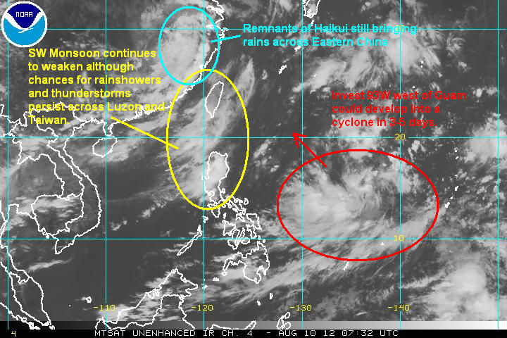
First up, the remnants of former Typhoon Haikui continues to bring widespread rains across Eastern China. So far, reports from the country put the death toll between 5 and 20 people--including 10 casualties caused by a dam collapse in the province of Zhejiang. Unfortunately, heavy rains continue across many provinces in China as seen on the radar image below. Nearly 600mm of rain has already fallen in many areas in the past 3 5 days. As the remnants of Haikui slowly dies, there could still be another 300mm of rain falling in the next 2 days.
Radar from CMA

Southwest Monsoon
The Southwest Monsoon (Hanging Habagat) continues to bring rains across parts of Luzon, particularly across Central and Northern Luzon. The weather remains generally clear for Manila, however, allowing many municipalities to start the daunting task of cleaning up the mess left behind by the floods. As for the north, clusters of thunderstorms continue to form and are still affecting the provinces of Zambales, Pamgpanga, Tarlac, and nearby ares. In fact, the continued precipitation here disrupted President Aquino's flight towards the flood-stricken areas to the north.
Radar from ClimateX

While there are still rains across Luzon, the intensity and duration have obviously been far better than what moved across days ago. Nevertheless, keep in mind that isolated thunderstorms can still form in some places, even in Manila especially during the afternoon and evening hours. For more radar images and rainfall forecasts across the Philippines, please visit ClimateX PH HERE
Invest 93W
Finally, we have Invest 93W a low pressure area approximately 300km west of Guam. This system is still in the early stages of development and the region is somewhat favorable for development. JTWC is giving 93W a LOW chance of development in the next 24 hours. Computer models continue to show development from this system and we could possibly see a weak cyclone forming here in the next 3 to 5 days. Based on current projections, this next system could enter the Philippine Area of Responsibility next week although a landfall across the Philippines is unlikely.
We'll have another Tropical Update tomorrow.
_________________________________________________
Issued (0930 UTC) 530pm PhT 081012
No comments:
Post a Comment