IR Image from NRLMRY
Invest 93W
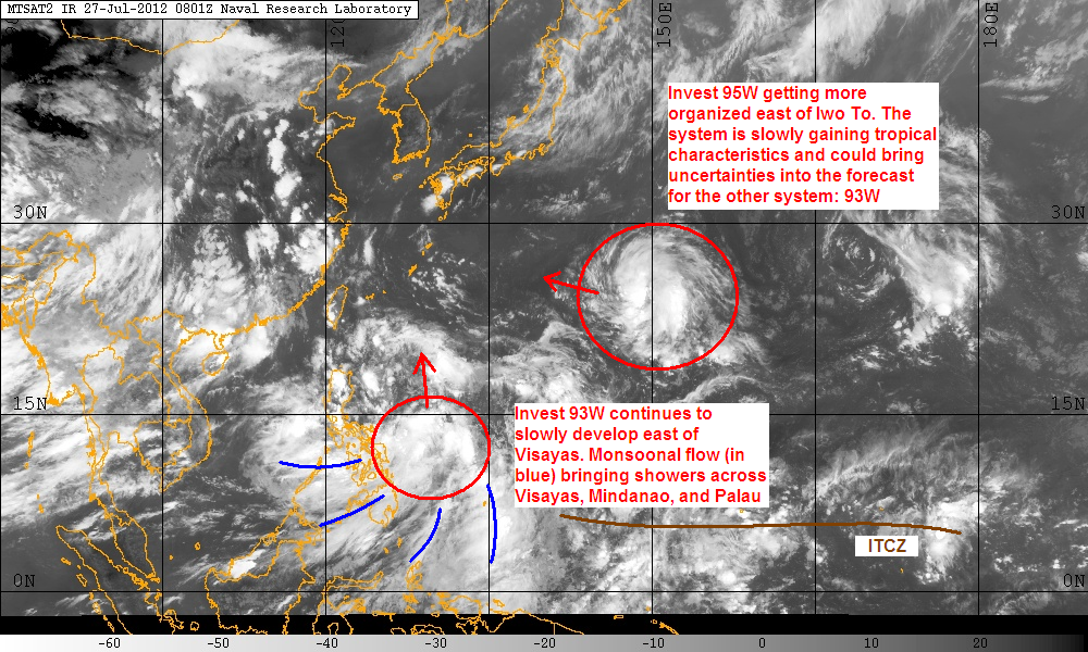
Invest 93W continues to slowly consolidate east of Visayas. The system remains in an area of moderate wind shear which is hampering continuous development. Furthermore, recent analysis reveals the low-level center is still somewhat elongated and recent satellite images show that much of the convection remain weak and unorganized. However, 93W will now be moving into weaker wind shear which should allow the system to start getting more organized. Computer models continue to develop the system and we have high confidence that 93W will become a cyclone in 24 to 48 hours. In fact, JMA has already upgraded 93W into a Tropical Depression and expects it to intensify into a Tropical Storm in about 24 hours. JTWC, on the other hand, is keeping its MEDIUM rating on the system. Since it is inside the Philippine Area of Responsibility, Invest 93W will get the local name 'Bagyong Gener' if PAGASA upgrades the LPA to a Tropical Depression.
93W is also enhancing monsoonal flow bringing showers across Visayas, Mindanao, and even as far east as Palau. Areas mentioned should expect scattered light to moderate rains with amounts ranging from 30 to 60mm. Models predict a slow movement in the next 2 days so these rains could very well continue right through the weekend. Rest of the Philippines will have partly cloudy skies with occasional thunderstorms, especially in the afternoon and early evening hours.
Invest 95W
This low pressure area was spotted well east of Iwo To and moving west northwestward at about 15kph. JMA has already upgraded the system to a Tropical Depression and they are also expecting 95W to become a Tropical Storm in 24 hours. JTWC, meanwhile, has increased the system's chances to MEDIUM. Invest 95W is currently exhibiting sub-tropical features having developed from a Tropical Upper Tropospheric Trough zone. However, latest analysis suggest that the system is beginning to take on tropical characteristics. Sea surface temperatures in the region are around 28 to 30C and are favorable for development. The system is also under an upper-level anticyclone which is promoting very good radial outflow in the system.
While the computer models are only beginning to pick up the system, 95W is slowly consolidating in the Pacific and could also become a cyclone in the next 2 to 3 days. Obviously, its future development will bring significant uncertainties with our forecast with 93W. Depending on the trends, these two systems could move to each other and will be close enough to start a Fujiwhara Effect. If Fujiwhara does occur, it will be difficult to predict the eventual track of both systems.
We'll have another update on both systems tomorrow afternoon (morning if one or both of them develops into a cyclone).
_______________________________________________
Issued (0930 UTC) 530pm PhT 072712
No comments:
Post a Comment