-For the latest Text Update on Damrey, please click HERE
Tropical Storm Saola (Bagyong Gener) continues to sort out development issues as it moves across the Philippine Sea. Saola/Gener was last located approximately 440km east of Aparri, Cagayan. Maximum sustained winds remain at 85kph with gusts of up to 120kph. Saola is currently moving northwestward at 10kph.
As of 5pm today, PAGASA and its Public Storm Warning Signal #2 remains in effect for Cagayan, Calayan Group of Islands, Babuyan Group of Islands, and Batanes Group of Islands. Signal #1, on the other hand, remains in effect for Isabela, Kalinga, and Apayao. These areas should continue to expect stormy conditions with heavy rains, strong winds, and rough waves along the coast. Rainfall amounts could reach up to 100mm especially in the mountainous areas.
IR Image from NRLMRY

Saola (Gener) is still trying to sort out the issue brought by the multiple circulations in the system. Latest satellite images are showing better organization with convective activity starting to wrap around the center. This could indicate another round of intense convection and strengthening throughout tonight. Saola also continues to enhance the SW Monsoon; coupled with the feeder bands, widespread rains abound for Luzon and Visayas. Some areas could see more than 50mm tonight bringing the chance of flash floods and landslides. This is a dangerous situation as the rains continue for a few more days so please continue watching the news and consulting local officials for the latest updates in your area.
Forecast Track (NOT OFFICIAL!)
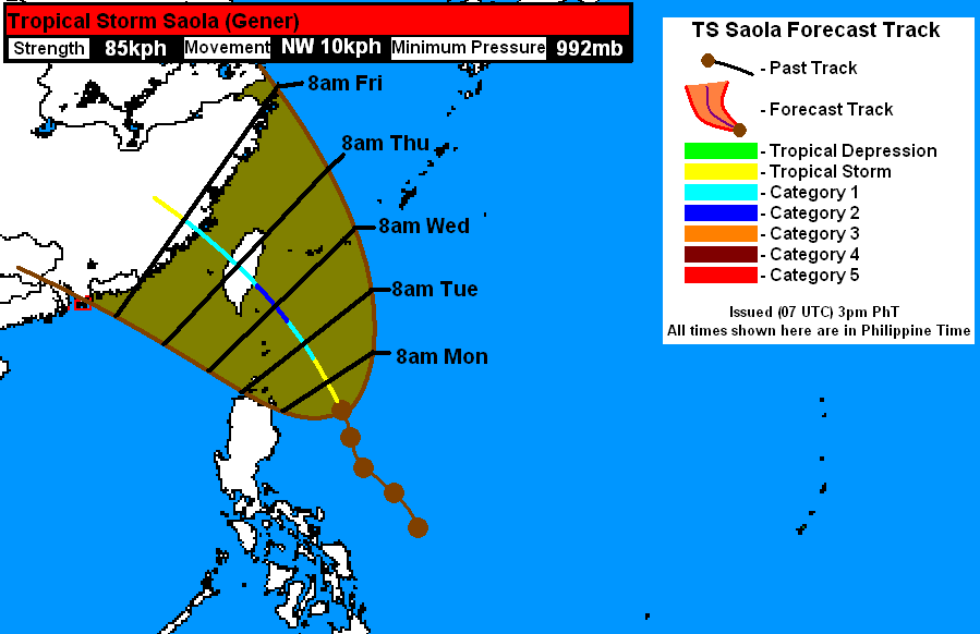
Tropical Storm Saola (Bagyong Gener) will continue moving slowly to the northwest, intensifying along the way. Areas under the Signal Warnings from PAGASA will continue getting stormy conditions throughout tonight and into tomorrow. Based on the trends, Saola could intensify to a typhoon as early as tomorrow night (Monday). There is better consensus among the forecasting agencies today and all of them are basically agreeing on a track towards Eastern Taiwan. Barring any major changes in the track, Saola could make landfall as early as Wednesday afternoon as a strong Typhoon. There is a small chance of rapid intensification to happen tomorrow and if it does happen, Saola could strengthen to a Category 2 or even a Cat 3 typhoon before making landfall. Another uncertainty here is the effect of Damrey. Right now, the two systems are still far apart to exert influence.
We'll have another update on Saola tomorrow morning.
____________________________________________
Issued (11 UTC) 7pm PhT 072912
No comments:
Post a Comment