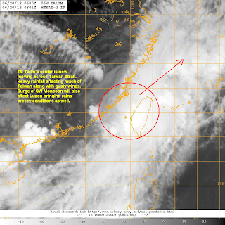
Tropical Storm Talim is now moving across the Taiwan Strait. The storm was last located approximately 190km south southeast of Xiamen, China or about 210km southwest of Taipei, Taiwan. Maximum sustained winds remain at 85kph with gusts of up to 110kph. Talim is currently moving northeastward at 20kph.
Talim has entered the Philippine Area of Responsibility prompting PAGASA to issue the local name 'Carina' to the storm. However, we are not expecting any direct impacts from the storm and no Signal Warnings have been issued by the agency. Talim (Bagyong Carina) should exit PAR later tomorrow (Thursday).
Latest reports out of Taiwan indicate sustained winds of 35 to 70kph with some areas reporting gusts of up to 120kph; particularly in the southwestern parts of the island. Furthermore, radar data out of Taiwan indicate bands of heavy rain impacting much of the country. Many areas have already reported rains of 150mm for today and more could be on the way. Most of Taiwan will see worst conditions tonight with strong winds and heavy rains amounting to 200mm in many spots. Always coordinate with the local authorities for the latest and OFFICIAL warnings and forecasts for your area. For the latest radar image out of Taiwan, please click HERE (Taiwan CWB Website)
Radar Image from CWB
Satellite data suggests an elongating and partly-exposed low-level circulation center which is still being impacted by the strong northerly shear. Further south, the storm is enhancing the SW Monsoon bringing showers across parts of Western and Northern Luzon. There could rainfall amounts of up to 100mm along with breezy conditions and rough waves for Luzon.
IR Image from NRLMRY
Talim should exit to the East China Sea later tomorrow. However, expect rains for Taiwan to continue for another 12 to 24 hours. Talim will begin weakening as it approaches Japan by Thursday night/Friday morning and should be downgraded into a depression as it makes landfall in Kyushu. It will then transition into an extra-tropical cyclone as it moves over Japan.
Forecast Track (NOT OFFICIAL!)
We'll have another update tomorrow. Stay safe!
_________________________________________________
Issued (0930 UTC) 530pm PhT 062012


No comments:
Post a Comment