IR Image from NRLMRY

PHILIPPINES 3-DAY FORECAST
Forecast Graphic, NOT OFFICIAL!
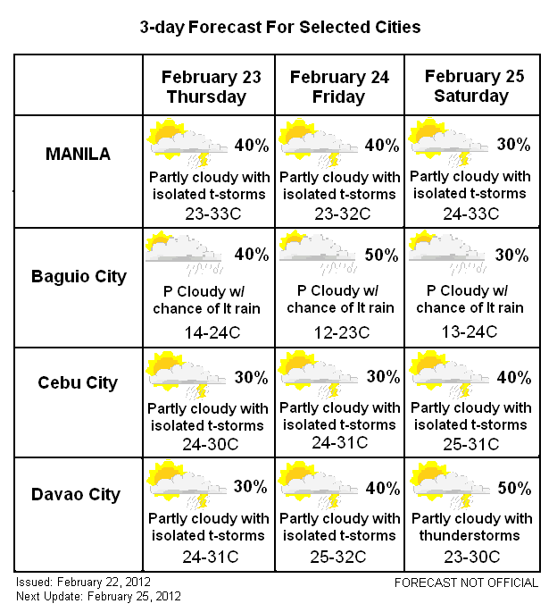
Numerous thunderstorms have popped up today across the region. Some of the precipitation can be locally heavy although not expecting to linger for much long. As the sun sets, these thunderstorms should begin losing energy and die down. Nevertheless, there could be some isolated areas that could receive more than 50mm which could definitely cause flooding and landslides. Clear weather is expected for tomorrow although rain could return by Friday, especially along Northern and Eastern Luzon as the cold front dives down from the north. Temperatures will be warm as the skies clear with Manila reaching low to mid 30s for daytime high.
Visayas
Same story here: mostly clear with isolated thunderstorms. Temperatures will be warm here as well, except for coastal areas which will benefit from sea breeze thus keeping the temps cool just a bit. Some showers could form by the weekend, though, as the ITCZ tries to push westward. Not expecting widespread precipitation so just kept the chances at 40% by that time.
Mindanao
Warm and clear for Mindanao as well. Mostly clear except for some thunderstorms which shouldn't last long. Temperatures will run between upper 20s to mid 30s all week. Rain could return by this weekend as the ITCZ arrives from the east. More chances for rain here compared to Cebu so gave Davao a 50% chance.
We'll have another update by Saturday, February 25.
_______________________________________
Issued (09 UTC) 5pm PhT 022212
No comments:
Post a Comment