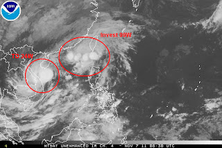
A new Tropical Depression has formed today, nearly a month after the last storm--Banyan--moved across the South China Sea.
TD 24W was last located approximately 270 east of Da Nang in Vietnam. Maximum sustained winds are at 45kph gusting to 55kph. 24W is moving north northeastward at around 25kph. Latest IR image from NRLMRY shows CDO-like convection with very cold cloud tops blowing around the low level center. Outflow is spreading light to moderate rain across parts of Northern and Central Vietnam. These rains could bring up to 100mm in less than 24 hours so please be careful of flooding and landslides.
IR from NRLMRY
JTWC is forecasting 24W to continue moving generally northward. It could approach the island of Hainan as early as Tuesday afternoon (local time). It is not expected to intensify significantly due to projected increase in wind shear as well as future land interaction with Hainan. Nevertheless, it will still bring heavy rains and gusty winds across these region for the next 3 days.
Invest 99W, meanwhile, remains somewhat disorganized as it drifts around South China Sea, southwest of Taiwan. ASCAT pass suggests an elongated low level center with winds of up to 50kph. Wind shear near 99W ranges from 20 to 30kt which is very hostile for further development. JTWC is still keeping its "MEDIUM" rating for 99W, however.
99W is not expected to bring heavy rain across the Philippines anymore, expect for some scattered showers across extreme Northern Luzon.
IR analysis showing the location of 99W and 24W
_______________________________________
Issued (0930 UTC) 530pm PhT 110711


No comments:
Post a Comment