_______________________________
Typhoon Danas is now moving north into the East China Sea after crossing the Ryukyu Islands earlier this afternoon. The eye of Danas was last located approximately 200km north of Okinawa. Maximum sustained winds remain at 215kph with gusts of up to 260kph; however, Danas peaked just below Super Typhoon status between our updates. Danas is currently moving north northwestward at 30kph.
IR Image from FNMOC
Latest satellite image shows the eye of Danas remains well-defined even though convection continues to slightly weaken. Radial outflow remains robust and that is probably helping to limit the weakening amidst the cooler sea-surface temperatures and increasing wind shear.
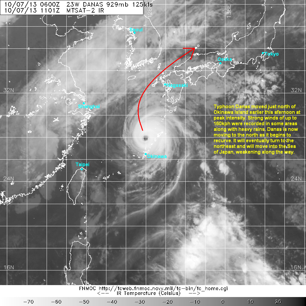
Typhoon Danas moved just north of Okinawa Island between 3pm and 4pm local time. It brought strong typhoon-force winds not only across Okinawa but also to the small islands to the north (including Amami). Many stations reported seeing winds of up to 160kph including one station that saw an instantaneous gust of almost 200kph!
Radar Image from JMA

Typhoon Danas is also bringing with it, bands of light to moderate rains. Pockets of heavy rains also impacted the islands earlier today bringing as much as 60mm of rain in just one hour! So far, rainfall totals in the region range from 50 to 150mm. Rain should start to weaken, though, across Okinawa and then Amami. For the latest radar images and forecasts from Japan, click HERE (JMA Website).
Typhoon Danas should start to weaken now that it is starting to encounter somewhat hostile conditions. It will also start to recurve to the northeast around the subtropical ridge. Danas will also begin extra-tropical transition possibly by tomorrow as it nears Kyushu Island. Despite the forecast weakening, Danas will still bring strong winds and heavy rains across Kyushu and Western Honshu. By Wednesday, Danas will move into the Sea of Japan bringing stormy conditions across parts of Honshu.
We'll have another update tomorrow.
No comments:
Post a Comment