*******************************
Text Update
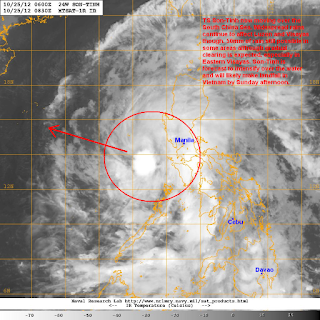
Tropical Storm Son-Tinh (Bagyong Ofel) is now moving away from the Philippines but is still bringing widespread rains across the country. The storm has just exited Mindoro Island and was last located approximately 240km west southwest of Manila. Maximum sustained winds are at 75kph with gusts of up to 95kph. TS Son-Tinh (Ofel) is moving west northwestward at 30kph.
As of 5am this morning, PAGASA have dropped Signal #2 and #1 for many areas. However, there are still some provinces under Public Storm Warning Signal #1; these are: Metro Manila, Bataan, Zambales, Cavite, Batangas, Northern part of Mindoro, and Lubang Island. Areas still under the signal warning may continue to expect winds of up to 60kph. Sea travel is also prohibited so please check with the port officials or ferry company for any delays or cancellations.
IR Image from NRLMRY
Tropical Storm Son-Tinh has taken somewhat of a beating as it moved across the Visayas Islands. However, the core of the storm remains intact and we are actually starting to see a new blob of convection forming near the center of circulation. We'll continue to monitor this new blob to see if it can sustain itself and if it is indeed a sign of recovery.
Subic Radar from PAGASA's Project NOAH
For now, widespread rains will continue across Western Visayas and Central and Southern Luzon including Metro Manila. Son-Tinh moved across Visayas yesterday bringing rainfall amounts of up to 150mm in many areas. Today, we are seeing similar amounts being reported in the provinces across Mindoro, Batangas, and Cavite. Some of these rainshowers can bring as much as 30 to even 50mm of rain in just one hour so please be wary of flashfloods and landslides. We are expecting another 50 to even 100mm to fall tonight and into tomorrow. For the latest radar images and rainfall forecast for your area, please visit PAGASA's Project NOAH website by clicking HERE
Forecast Track (NOT OFFICIAL!)
Tropical Storm Son-Tinh (Bagyong Ofel) is now accelerating across the South China Sea or the West Philippine Sea and may leave the Philippine Area of Responsibility by as early as tomorrow morning (Friday). Expect better weather conditions, especially in Eastern Visayas, by tomorrow and eventually by Saturday much of the country should be experiencing quieter weather allowing for smoother travel as the All Saints Day approaches.
TS Son-Tinh is forecast to continue intensifying over the open waters due to the favorable conditions in the region. There is a small chance of this system becoming a Typhoon by Saturday and that is what the Joint Typhoon Warning Center is showing. Due to the recent trends, we have decided to side with the JTWC and so we are also expecting Son-Tinh to briefly reach Category 1 intensify by Saturday as it passes south of Hainan Island. By Sunday, Son-Tinh is forecast to make landfall in Vietnam as a weakening Tropical Storm and could pass just south of Hanoi. Typhoon or Tropical Storm, Son-Tinh will surely bring widespread rains, strong winds, and rough surf in Vietnam and the rest of Indochina by Sunday and early part of next week.
We'll have another update tomorrow.
________________________________________________
Issued (0930 UTC) 530pm PhT 102512


No comments:
Post a Comment