As of 5am this morning, PAGASA has raised Public Storm Warning Signal #2 for Eastern Samar. Signal #1 is in effect for Sorsogon, Northern Samar, Western Samar, and Leyte. These provinces will experience windy conditions along with rainshowers that could amount as much as 100mm throughout today. Continue checking updates with your local authorities for any evacuations and other warnings.
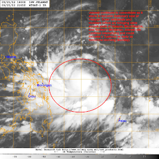
IR Image from NRLMRY
Latest satellite image shows a central dense overcast that is starting to form and consolidate. Equatorward outflow remains good while the poleward outflow is improving. Outer rainbands are already impacting Visayas and Southern Luzon and moisture inflow are also bringing scattered rainshowers across Northern Mindanao. Rainfall totals could amount up to 100mm today in some areas.
No major changes with the forecast track for this morning although we are starting to notice an eastward movement among the computer model solutions. For now, we expect Jelawat to continue slowing down and eventually become quasi-stationary as it stays east of Samar. It will also continue to intensify and could become a typhoon tomorrow morning.
We'll continue watching the trends today and we'll update our forecast track accordingly. We'll have another update later this afternoon.
You can watch our Video Update from yesterday to give you an idea on the numerous solutions that are being shown by the computer models.
________________________________________________
Issued (23 UTC) 7am PhT 092212

No comments:
Post a Comment