Typhoon Haikui has made landfall along the coast of Zhejiang Province this morning. The system was last located approximately 20km south of Ningbo City or about 230km south of Shanghai. Maximum sustained winds are at 120kph with gusts of up to 155kph. Haikui is currently moving northwestward at 15kph.
As of 5am this morning, the China Meteorological Administration have now raised Red Warning as Typhoon Haikui makes landfall. The agency has also raised Yellow Warning for the rains associated with Haikui that could amount as much as 400 or even 500mm. Haikui is and will affect the provinces of Zhejiang, Jiangsu, Jiangxi, Anhui, Fujian, and Shanghai. If you are in these regions, please continue to monitor the developments in your specific area.
Radar from CMA
Latest radar near Ningbo shows that the center of Haikui is now moving over land with bands of heavy rain also moving into Zhejiang Province. Many stations have now reported 100 to 200mm of rain overnight. Sustained winds continue to reach typhoon force of around 120kph with gusts of up to 140kph also being reported. Rains will continue throughout the day and in the next 2 days. There could be rainfall totals of up to 500mm in some areas so please listen to your local officials for warnings. Winds will remain although they'll start to get weaker as Haikui moves further inland. For the latest radar images, forecasts, and warnings from China, please click HERE (CMA Website)
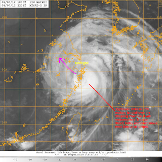
IR Image from NRLMRY
Satellite image shows the eye of Haikui along the coast of Zhejiang. Haikui will weaken to a Tropical Storm today as it moves over land. It will continue to bring strong winds and heavy rains in the regions mentioned above today and into tomorrow. Haikui will be slow to move across Eastern China and could become a Tropical Depression by as early as Friday morning. The forecast tracks have shifted somewhat and most agencies are now showing a late recurve (some not expecting it anymore).
Southwest Monsoon (Hanging Habagat) Update
Rains continued overnight although the intensity wasn't as hard as it was compared to yesterday. Still, some stations reported 50 to 100mm of rain in the past 12 hours. And while some areas are reporting that the floods are starting to recede, many communities--especially along rivers and near the dams--are still underwater. Marikina and Tullahan Rivers are still at critical (if not spilling) levels while La Mesa Dam is still overflowing with the last update putting the water level at 80.38m. Several roads are still flooded which prompted many schools and even offices to close today. Continue monitoring the developments on TV and on the web for the latest developments in your area.
Radar from ClimateX
Unfortunately, expect more round of showers in Manila later today but should not be as heavy as in the past 36 hours. The heaviest of rains are now situated across Central Luzon so provinces such as Zambales, Bataan, Pampanga, Tarlac, Bulacan, and even Pangasinan should still be on alert for heavy rains throughout the day. Many areas here could see as much as 100mm of rain so please always listen to your local officials. For more radar images and rain forecasts, please head to ClimateX (NOAH Alternative): click HERE
We'll have another update later today. If you have any storm reports please email them to us at philippineweather@yahoo.com
______________________________________________
Issued (2330 UTC) 730am PhT 080812


No comments:
Post a Comment