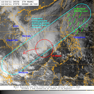
Tropical Storm Washi (Sendong) continues to move away from Palawan and Mindanao and is beginning to exit the Philippine Area of Responsibility. The center of the storm was last located approximately 400km west northwest of Puerto Princesa City or about 940km east southeast of Ho Chi Minh in Vietnam. Maximum sustained winds remain at 85kph gusting to 110kph. Washi has also begun to turn to the west southwest and is moving at 30kph.
All signal warnings have now been dropped by PAGASA. Even though Washi is now moving away from the country, the death toll in Mindanao continues to climb and has already surpassed the 500 people-mark today. The Philippine Red Cross estimates that as many as 400 people are still unaccounted for. We haven't really received any casualty reports out of Palawan yet and let us hope it stays that way.
As we have forecast yesterday, weather conditions are now beginning to improve for much of Mindanao, allowing rescuers to do their job in finding the victims. However, there will still be some scattered rain showers, particularly in the Eastern Sections of Visayas, Southern Luzon, and Northern Luzon as the NE Monsoon continues to affect the said areas. The Visual Satellite Image from NRLMRY below shows the last location of Washi as well as a long convergence line that has set up over the South China Sea. This line of thunderstorms indicate a clash of windflow as the NE Monsoon surge and easterlies meet. The line stretches from as far south as Malaysia, northeast towards Luzon. Expect light to moderate rains for the next 24 hours. Rainfall out of Luzon and Visayas today range from 50 to 100mm, expect the same amounts for at least the next 2 days.
VIS Image from NRLMRY
Going back to TS Washi, the storm has begun to reorganize a little bit as it moves over the open waters of South China Sea. However, we expect intensification to be limited due to increasing wind shear and drier air brought by the monsoon surge. Additionally, sea surface temperatures in the SCS will decrease as Washi moves westward.
As far as the track, we have shifted our forecast southward to account for the recent turn, as well as latest computer guidance. Hence, the track is now aligned with most weather agencies in the basin. We forecast Washi to continue moving west southwestward, moving south of Vietnam. It will be approximately 400km south of Ho Chi Minh come Tuesday morning. Washi will then start to weaken as conditions become unfavorable. It is forecast to become a Tropical Depression by Tuesday and will likely dissipate by Wednesday. Its remnants will likely move into the Malay Peninsula, north of Singapore.
Personal Forecast (NOT OFFICIAL)
We'll have another update tomorrow morning.
_______________________________________
Issued (0930 UTC) 530pm PhT 121811


No comments:
Post a Comment