As of 11am this morning, PAGASA has raised Signal #1 for Eastern Samar, Western Samar, Leyte Provinces, Bohol, Biliran, Camotes Island, Northern Cebu, Northern Negros, Northern Iloilo, Capiz, Masbate, Ticao Island, Surigao Del Norte, Siargao Island, Surigao Del Sur, Agusan Del Norte, Dinagat Island, and Camiguin Island.
These areas will receive widespread moderate to heavy rains with winds of up to 60kph. Conditions should begin to deteriorate tonight. We are actually already receiving 24-hour rainfall reports of 50 to 100mm across Cotabato, Lumbia, and Hinatuan in Mindanao. Furthermore, Cebu is already reporting light rain as of this moment. Total rainfall in this region could reach up to 300mm!
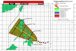
TS Banyan (Ramon) is forecast to continue moving northwestward. It could approach the Surigao Provinces (including Dinagat and Siargao Islands) by early tomorrow morning. It will then continue moving across the Visayas Region, passing through Leyte, Cebu, and Panay Island by Wednesday night. Banyan could reach Romblon and Mindoro Island by Thursday morning.
Our forecast track agrees with the model consensus and is in agreement with the latest JTWC forecast. We want to note that JMA is actually forecasting a slightly more northward track, bringing Banyan towards Samar and eventually into Southern Luzon (see Video for more details). Keep in mind that forecasts can change and we might have to fine tune our track so please stay updated!
Personal Forecast (NOT OFFICIAL)
Video Update
We'll have another update tomorrow morning. Stay safe!
_______________________________________
Issued (0830 UTC) 430pm PhT 101111

No comments:
Post a Comment