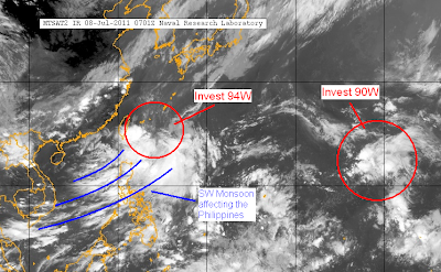
The image below, from NRLMRY, shows the location of the two LLCC's and the possible location of the LPA. The blue arrows indicate the general wind pattern based from reports in Japan (JMA) and Taiwan (CWB) as of 06 UTC.

As for the forecast, computer models are still forecasting a weak cyclone to develop in this area in the coming days. Furthermore, JMA is actually forecasting this LPA to become a weak tropical depression as early as tomorrow. JTWC, meanwhile, has upgraded the LPA's chances to "Medium". Based on the forecasts, it looks like it'll mainly affect Taiwan and Eastern China bringing heavy rain into next week.
Moving now to Invest 90W, the system continues to track westward across the Pacific. IR images show cooling cloud tops although the LPA as a whole is still largely disorganized. A recent SSMIS 37Ghz microwave image shows improved low level activity although banding is still not observed. The LPA is in an area with high sea surface temperatures but is encountering moderate westerly wind shear of about 20kts.
Computer models continues to show a cyclone developing in this area in the next 2-3 days.

As for the Philippines, Southwesterly monsoonal flow continues to affect most of the Philippines, with the bulk of activity near Luzon. Places here will continue to experience increased chances for rain showers as well as light to moderate southwesterly winds of abour 10-20kph. The same goes for Visayas although with lesser chance for downpours. A lot of areas here will actually experience sunny to partly cloudy skies, except for some afternoon thunderstorms. Mindanao is south of the bulk of activity from the monsoon although areas will still experience showers from time to time.
___________________________________
Issued (0830 UTC) 430pm PhT 070811
No comments:
Post a Comment