 Latest Satellite Imagery from NRLMRY
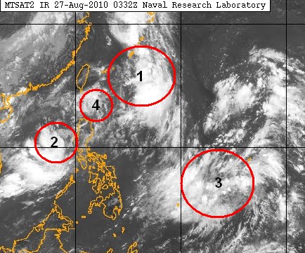
Tropical Disturbance 1 is located just south of Okinawa. It has the best chance of becoming a tropical cyclone. Models are predicting that this storm will move to the north.
Tropical Disturbance 2, west of the Philippines, is also getting better organized. It is moving west northwest and could be a Tropical Storm in 24-48 hours. JMA is actually classifying these two disturbances as Tropical Depressions already with winds of up to 55kph for both.
Tropical Disturbance 3 is well east of the country, around Guam. It doesn't look organized, nor are the models showing something from this area, but it's still worth keeping a close eye on.
Finally, we have Tropical Disturbance 4 on the northern side of the Philippines. Just like TD3, it doesn't look like it's intensifying but the GFS (Global Forecasting System), a numerical model, is predicting that it will be a storm soon. If it does, it will be moving to the north, into Taiwan.
__________________________________
Issued (06z) 2pm PST 082710
No comments:
Post a Comment