*********************************
Text Update
Prapiroon (Bagyong Nina) became a typhoon earlier this morning and continues to intensify as it moves across the Philippine Sea. The system was last located approximately 1,030km east of Luzon or about 1,070km south southeast of Okinawa. Maximum sustained winds are now at 120kph with gusts of up to 150kph. Typhoon Prapiroon is currently moving westward at 10kph.
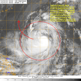
IR Image from NRLMRY
Latest satellite image shows Prapiroon continuing to consolidate, taking advantage of the favorable conditions in the Philippine Sea. The system looks symmetrical with good radial outflow. Strong convective activity is also present and is wrapping tightly into the storm's center. While the Prapiroon isn't showing an eye yet, recent microwave images (not shown here) suggest that the eyewall is becoming more organized and we may see that eye appear later this evening or perhaps early tomorrow morning.
Forecast Track (NOT OFFICIAL!)
We are starting to see a much better agreement among the computer models and forecast agencies today with a lesser spread in the tracks. As we get a better handling on the different factors that will affect Prapiroon's movement in the coming days, expect a consensus to become tighter. For now, our forecast track follows closely with the major computer models along with JTWC and JMA's forecast.
We expect Prapiroon to start turning to the north by Thursday, becoming a Category 2 Typhoon by that time. A mid-latitude trough currently diving down across Eastern China will create the weakness which will pull Prapiroon to the northeast by Friday and Saturday, away from land. However, there are still some uncertainties regarding the positioning of troughs and ridges. In fact, a couple of computer models are still showing Prapiroon hitting Okinawa by early next week. Due to the uncertainties that are still present among the models that we use, we have including a very big cone of error in our forecast track. Again, once we start getting a better idea of the steering factors, we expect the forecast tracks to become more aligned with the different agencies. With that said, there is an increasing chance that Prapiroon will avoid hitting any land in Asia.
We'll have another update tomorrow morning.
______________________________________________
Issued (0930 UTC) 530pm PhT 100912


No comments:
Post a Comment