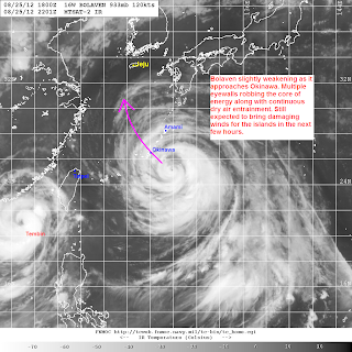
Typhoon Bolaven (Bagyong Julian) is slightly weakening as it approaches Okinawa. The storm was last located approximately 300km southeast of Okinawa. Maximum sustained winds are slightly down to 230kph with gusts of up to 270kph. Bolaven has also slowed down and is currently moving northwestward at 10kph.
JMA has now issued Storm, High Waves, and Storm Surge Warnings across Okinawa and the rest of the Ryukyu Islands. Kadena Air Base is now at TCCOR 1-Caution.
IR Image from NRLMRY
Latest satellite image shows a weakening state of Bolaven which should be a good news for Okinawa. Multiple eyewalls are robbing each other of energy resulting to multiple wind maxima inside the storm. Furthermore, due to the large size of Bolaven, there has been continuous entrainment of dry air into the circulation with convective activity being severely disrupt along the northern side of the system.
Radar Image from JMA
Latest radar image from Okinawa confirms the presence of multiple eyewalls of Bolaven with the first inner band about to hit Okinawa in 3 hours. This first band could bring sustained winds of up to 100kph along with heavy rains. Winds will continue increasing throughout the day with Typhoon-force winds of more than 120kph expected to begin in 6 hours. The peak winds of 200kph or more is forecast to hit Okinawa between 12pm and 6pm when the eye of Bolaven is expected to move across. For more radar images, warnings, and forecasts from JMA, please click HERE
Despite the weakening, Bolaven is still a dangerous typhoon, and could be Okinawa's biggest storm in years. Please do not take this system lightly and prepare accordingly. If you have storm reports, images or videos, please share them with us at philippineweather@yahoo.com
We'll have another update later this afternoon. Stay safe!
________________________________________________
Issued (23 UTC) 7am PhT 082612

No comments:
Post a Comment