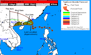
Vicente has intensified and has now been upgraded to a Typhoon by the JTWC. Typhoon Vicente was last located approximately 180km south southeast of Hong Kong. Maximum sustained winds are now at 120kph with gusts of up to 150kph. Vicente is currently moving north northwestward at 15kph.Please do note that Japan Meteorological Agency (JMA) is still holding Vicente at Severe Tropical Storm intensity.
As of 5pm today, Hong Kong Observatory has put the region under Strong Wind Signal No. 3 and is expecting winds of 40 to 60kph in the next few hours; coupled with bands of moderate rains. Residents are expected to continue monitoring the news for the latest warnings and forecasts for your area. In China, CMA has raised Yellow Alert as Vicente is forecast to make landfall in Guangdong Province tomorrow.
Radar Image from HKO
Outer rain bands are now affecting much of Hong Kong and nearby areas in Southern China. Radar image from HKO above shows the coverage of the light to moderate rains. The radar is also picking up the eye of Vicente which continues to move slowly to the north northwest. There could be as much as 50 to 100mm of rain falling tonight and into tomorrow. For the latest radar image in Hong Kong, please click HERE (HKO Website).
Aside from the rains, many areas in Hong Kong and nearby areas are beginning to report winds of 50 to 70kph. Winds are only forecast to gradually strengthen as Vicente moves closer to Hong Kong.
IR Image from NRLMRY
Latest satellite imagery depicts the warm spot signifying the development of an eye. Vicente has really gotten its act together in the past 6 hours as the wind shear has weakened and sea surface temperatures south of Hong Kong are very warm and favorable for intensification. Also highlighted is the extent of the SW Monsoon which is still being enhanced by Vicente. Many areas in Western Luzon continue to report rainfall amounts of 50 to 100mm, with some areas receiving nearly 200mm. The extent of the rain has lessened and is now more concentrated on the western parts of Luzon (provinces of Zambales, Bataan, and Pangasinan). The rest of the country should still expect scattered showers in the next few days although the rains should be lighter and not as widespread as before.
There has been a pretty significant shift in the forecast track for Typhoon Vicente. Reorientation in the ridge guiding the system has resulted in a slowdown, and as we've noticed today, a movement directed more to the north northwest. This means that Vicente will now move closer to Hong Kong than what we've previously thought. Our latest forecast track now takes Vicente within 200km of Hong Kong later tonight and early tomorrow morning. While we're not expecting typhoon-force winds to lash Hong Kong, there will still be winds of up to 100kph and widespread rainfall. Vicente is forecast to make landfall near Yiangjiang in Guangdong Province tomorrow afternoon (midday) as a Category-1 typhoon. Vicente still has around 12 hours on water so it could still intensify before it makes landfall.
Forecast Track (NOT OFFICIAL!)
Vicente will then track across Guangdong Province weakening along the way. We have shifted our forecast to the north and we no longer expect Vicente to emerge in the Gulf of Tonkin. By Wednesday morning, Vicente is forecast to cross into Vietnam as a weakening Tropical Storm. It will then rapidly weaken to a Tropical Depression Wednesday afternoon and will pass just north of Hanoi by Wednesday night. It is forecast to dissipate as early as Thursday morning.
Please continue monitoring HKO, CMA, JMA and the local news for the latest warnings and forecasts on Vicente. For more info on the Invest 93W near Palau, which could develop in the next few days, please check out our video update posted earlier today.
We'll have another update tomorrow morning. Stay safe everyone!
_____________________________________________
Issued (0930 UTC) 530pm PhT 072312


No comments:
Post a Comment