Issued (0030 UTC) 830am PhT 070915
_________________________________
Linfa (Bagyong Egay) has intensified overnight and is now a Category 1 Typhoon. The storm's center was last located approximately 60km south of Shantou or about 260km east of Hong Kong. Maximum sustained winds are now at 120kph with gusts of up to 150kph. Typhoon Linfa is currently moving west northwestward at 15kph.
The National Meteorological Center of China has issued a Yellow Typhoon Warning for the possible impacts of Linfa to Fujian and Guangdong Provinces. Meanwhile, Hong Kong Observatory has issued Signal Force No. 1 for the expected impacts from Linfa. Please heed the warnings of your local officials for the latest warnings and bulletins.
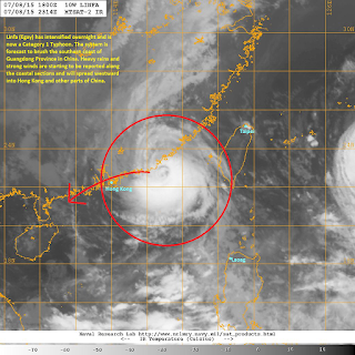
IR Image from NRLMRY
Latest satellite image shows Linfa has developed a small, but rugged, eye surrounded by strong convective activity. Microwave analysis (not shown here) reveals a well-developed eyewall with deep banding developing. Thankfully, Linfa is now nearing land and should no longer intensify significantly.
Radar Image from CMA
Latest radar image out of Guangdong Province shows the well-defined eyewall of Linfa characterized by bands of light to moderate, and sometimes, heavy rains. Some places have already received well upwards of 50mm of rainfall along with winds of up to 100kph. Stormy conditions will continue across the region, especially along the coastal areas, through this evening. Parts of Hong Kong will also start to see stormy conditions from Linfa beginning tonight and will last through tomorrow.
For China Meteorological Agency Website, please click HERE
For Hong Kong Observatory Website, please click HERE
We'll have another update later tonight.


No comments:
Post a Comment