Issued (01 UTC) 9am PhT 100413
____________________________
Typhoon Fitow (Bagyong Quedan) continues to intensify as it nears the Southern Japanese Islands. The eye was last located approximately 520km southeast of Okinawa, Japan or about 900km east southeast of Taipei, Taiwan. Maximum sustained winds are up to 150kph with gusts of up to 185kph. Typhoon Fitow is currently moving northward at 10kph.
Kadena Air Force Base has now issued TCCOR 2 for the possibility of 50kt (95kph) winds or greater occurring in the next 24 hours. Residents are advised to remove or secure all outdoor items. Japan Meteorological Agency has also issued Gale and High Waves Advisories across the Ryukyu Islands for the incoming storm. As always, we urge everyone living in the region to closely monitor the developments of Fitow. If you are in Okinawa or one of the nearby islands, please prepare now.
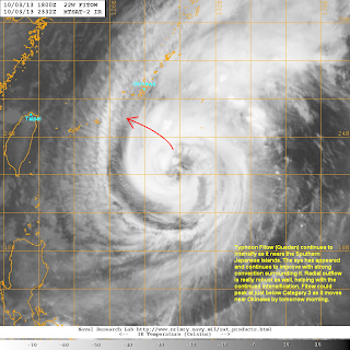
IR Image from NRLMRY
Latest satellite image shows the eye of Fitow continuing to improve with strong convective bands surrounding the center. Radial outflow remains robust as well, helping the system intensify. High cirrus clouds are beginning to move in to the Japanese Islands but the outer rain bands shouldn't affect the region until later this afternoon.
Forecast Track (NOT OFFICIAL!)
Typhoon Fitow will continue to move slowly to the north but we should see the system take a turn to the northwest later today. It will also continue to intensify due to the favorable conditions in the region. Fitow could reach a peak intensity of just below Category 3 Status by morning.
The critical part of our forecast is how close Fitow will get to Okinawa. Latest computer models are suggesting a sharp turn to the west, bringing the eye closer to Miyakojima than in Okinawa. Either way, the large nature of Fitow iwll mean that many islands here will experience Tropical Storm and even Typhoon-force conditions beginning tonight and into tomorrow.
By Saturday, we expect Fitow to move into Eastern China and weaken along the way. A landfall south of Shanghai by early Sunday morning is what we're currently expecting based on the latest available guidance.
We'll have another update later today.


No comments:
Post a Comment