Issued (2330 UTC) 730am PhT 091513
________________________________
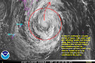
Tropical Storm Man-Yi continues to move towards Mainland Japan. It was last located approximately 700km northeast of Okinawa. Maximum sustained winds have slightly increased to about 95kph with gusts of up to 120kph. TS Man-Yi is moving north northwestward at 25kph.
IR Image from NOAA
Latest satellite image shows a tightened core with convective activity wrapping around it. Due to the large size of Man-Yi, significant amount of dry air has entrained into the circulation decreasing the amount and extent of convection. However, satellite analysis suggest that winds around the center has increased and the system as a whole is still very much intact.
Tropical Storm Man-Yi will continue moving quickly to the north. Light rain showers could start impacting Kyushu and Shikoku today. Furthermore, a frontal system bringing rains across Honshu will interact with Man-Yi causing it to transition into an extra-tropical cyclone. Man-Yi is forecast to move towards the island of Honshu by as early as tomorrow (Sunday).
We'll have another update later today.

No comments:
Post a Comment