Issued (15 UTC) 11pm PhT 080613
____________________________
Tropical Depression 10W (Kiko) has intensified into Tropical Storm Mangkhut. The system is currently passing just south of Hainan Island. It was last located approximately 360km south southwest of Haikou, Hainan or about 600km southeast of Hanoi, Vietnam. Maximum sustained winds are now at 65kph with gusts of up to 85kph. TS Mangkhut is moving northwestward at 30kph.
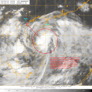
IR Image from NRLMRY
Latest satellite image shows a small core with good convective activity passing just south of the island of Hainan. Satellite analysis suggest a slight increase in wind speeds near the center prompting different agencies to upgrade the cyclone into a Tropical Storm. TS Mangkhut is moving quite fast for the core to really develop so we're not expecting significant intensification to occur before its projected landfall in Vietnam tomorrow.
Radar Image from CMA
Latest radar image out of Hainan shows bands of light to moderate rains impacting the southern half of the island. Rains will overspread much of the area tonight and into tomorrow. 50 to 100mm of rain is expected, especially near the southern coast. Weather should gradually improve in Hainan by tomorrow evening. For the latest radar images and forecasts from China, please click HERE (CMA Website).
Tropical Storm Mangkhut will continue moving northwesterly and should make landfall in Northern Vietnam tomorrow morning or afternoon (Wednesday) as a moderate Tropical Storm. It will be moving in the same areas that Jebi impacted a week ago bringing the same threat of winds and widespread rains. As much as 200mm is expected including in Hanoi over the course of 3 days.
We'll have another update tomorrow morning.

No comments:
Post a Comment